Eddie Sheerr

A Quiet Friday closes out the work-week

The Overview

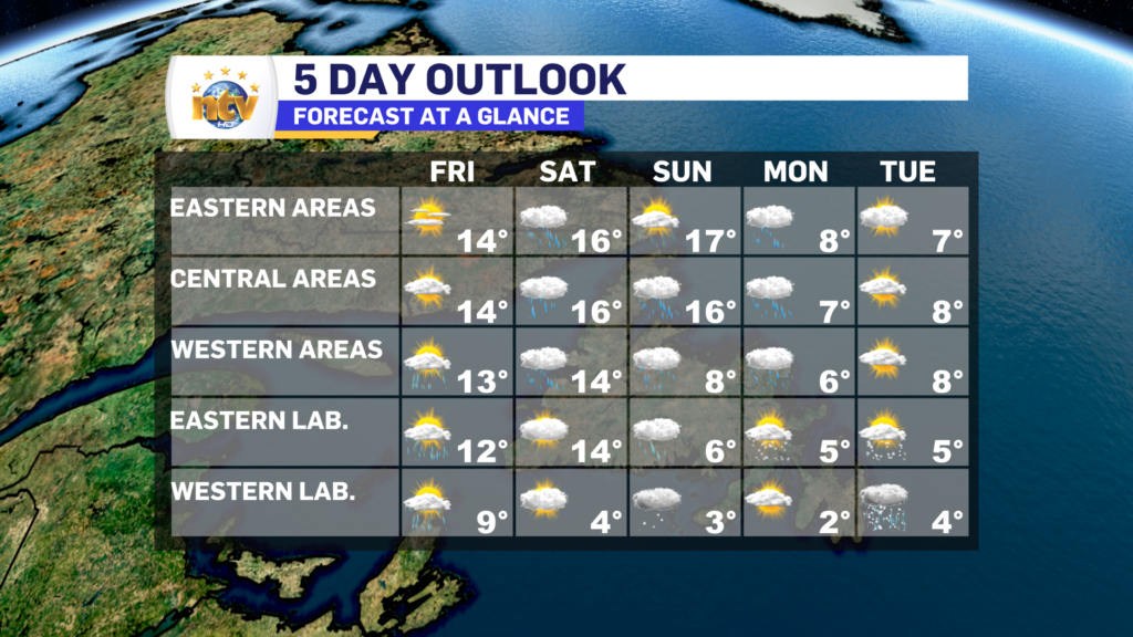
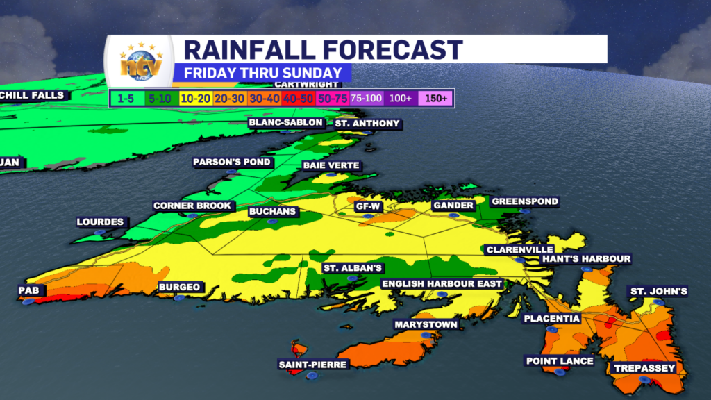
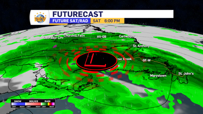
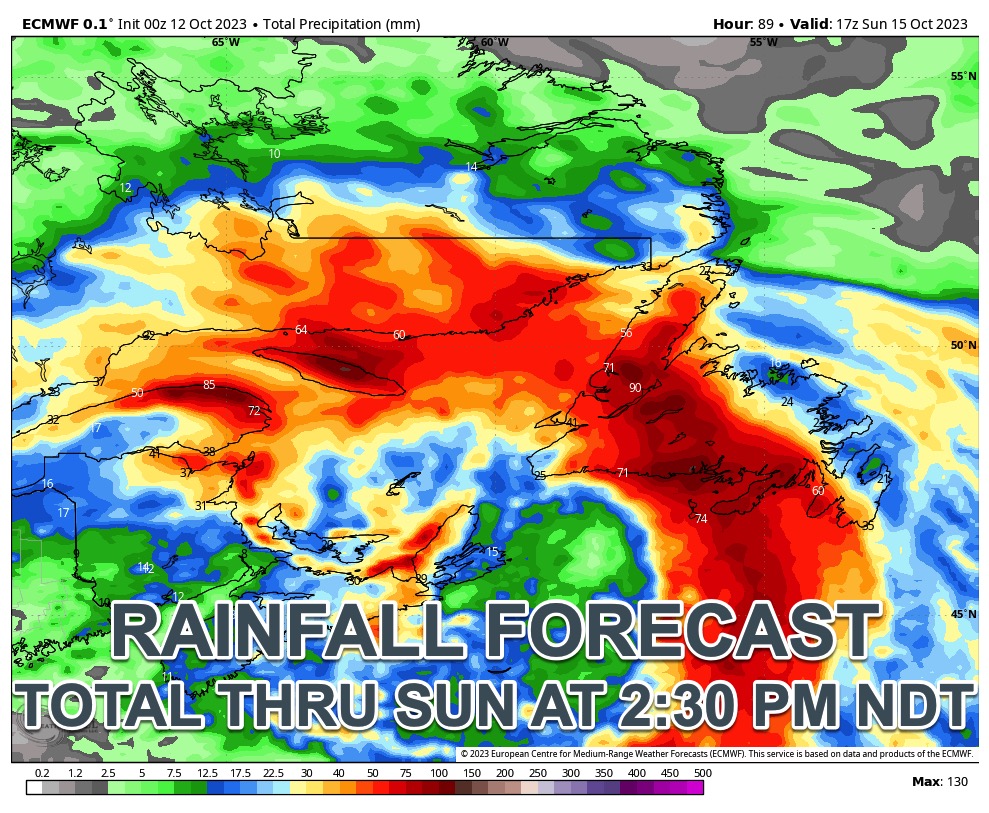
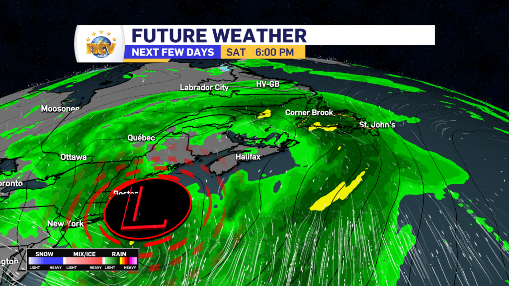
A ridge of high pressure will keep the weather quiet and relatively calm across the bulk of the Province overnight. The same ridge will generally keep things sunny and mild for Friday, however, a few showers will skirt into Labrador and western Newfoundland at various times during the day. The next big weather-maker, which is a deepening area of low pressure, will arrive Saturday and will not depart until later Sunday. This low will bring heavy rain and gusty winds to much of the Island from Saturday mid-morning through Sunday.

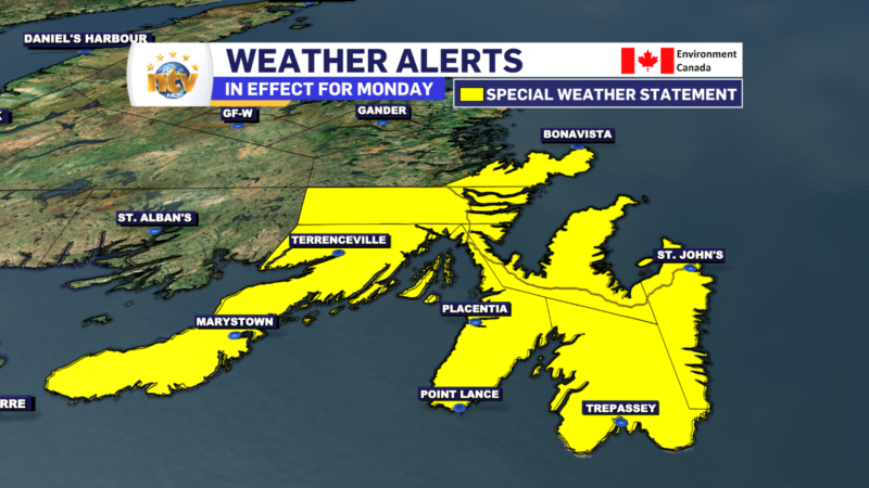
A follow-up low could bring another bout of lighter rain on Monday. Temperatures will remain relatively mild through Saturday, with cooler air arriving Sunday or Monday. Highs dip into the single digits by early next week Island-wide.

Meanwhile, in Labrador, expect a quieter weekend, but a turn toward cooler temperatures by Sunday. In fact, by early next week highs will only be in the lower to middle single digits, and flurries will be widespread. This is a sure sign of the season.

The Forecast

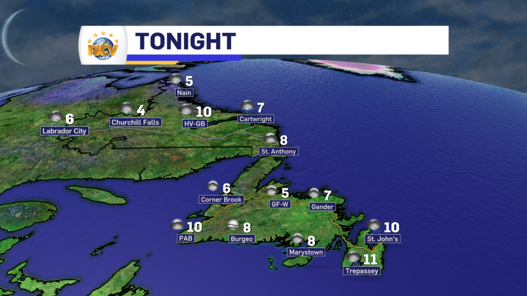
Thursday Night: Mostly clear on the Island with lows of 6 to 12. It will be warmest o the southwest coast and generally cooler elsewhere. Labrador will see partly cloudy to mostly clear skies, with a few showers late in the west. Some areas of the west may see flurries. Lows of 2 to 7.

Friday: Mostly sunny to start the day across the Island, however, clouds increase central, west, and south during the afternoon. There may be some showers late in the day on the West Coast and on the Northern Peninsula. Highs in the lower to middle teens.

Labrador will see scattered showers, under mostly cloudy to cloudy skies. Highs of 5 in the west to 12 in the east and 8 in the north.

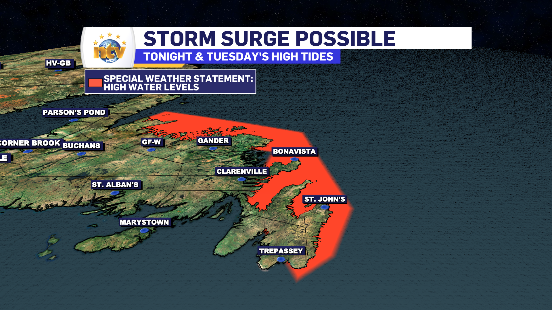
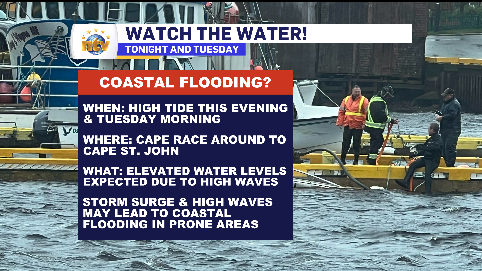
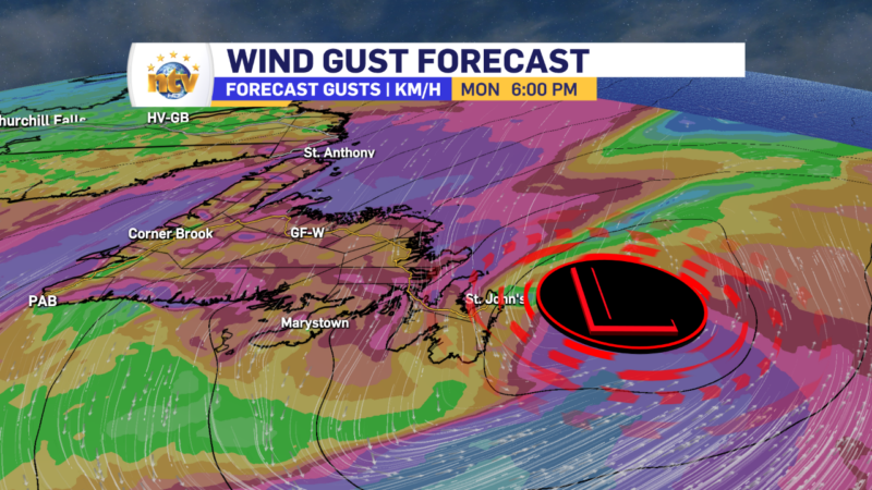
Saturday: Rain arrives on the Island during the late morning to early afternoon and will become heavy at times for most areas by evening. Wind speeds ramp up Saturday night and may gust to 100 km/h from the southwest during the overnight, over exposed areas. Highs on Saturday will be in the lower to middle teens.

Labrador will see mostly cloudy skies, with his of 4 in the west to 14 on the coast.

Sunday: Rain and showers will continue on the Island throughout the day. The best weather will likely be found in the east, where sunshine will be in the cards for the morning before showers return during the afternoon. Highs will be in the middle to upper teens south, central and east, while temperatures fall into the single digits in the west during the day.

Labrador will see scattered showers or flurries, with highs of 3 to 6.

Monday: Another chance of rain on the Island, with highs 6 to 8. Few flurries in Labrador under partly cloudy skies, with highs of 2 to 5.

Tuesday: Partly to mostly cloudy on the Island, in northerly flow. Highs near 7. Scattered flurries or showers in Labrador, with highs near 5.

Tuesday will be better for many, but that’s not exactly a tall task

The area of low pressure that, by in large, brought a miserable Monday to most of Newfoundland is pulling away, to the east, of the region this morning. This will improve the weather today, but northerly winds will keep clouds, a few showers, and seasonably cool temperatures in the cards today for much of the Island. Temperatures will reach the middle to upper single digits for highs this afternoon, and generally similar readings will be found in Labrador. Labrador will see a bit more sunshine, compared to the Island.

As the low slowly pulls away, there will be some high wave action along the east and north-facing shores of the Island from Cape Race (Southeast Avalon Peninsula) to Cape St. Johns (Baie Verte Peninsula). This high wave may generate higher than normal high tides this morning (7 AM to 10 AM) for the areas mentioned above. ECCC has issued a Special Weather Statement addressing the potential of minor coastal flooding. Those with interests in these areas, such as fishing vessels, should heed the alert and monitor your assets closely.

THE LONGER RANGE FORECAST

The remainder of the week will see generally quiet weather across the Province, with highs ranging from the single digits to lower teens. The next chance of rain looks to be late next weekend.

The weather slowly improves Monday night, after a fairly miserable day

The area of low pressure that, by in large, brought a miserable day to most of Newfoundland is going to slowly depart overnight. This means areas of southern, eastern, central, and northeastern Newfoundland have to deal with rain and gusty winds into the early morning of Tuesday.

On top of that, temperatures are only going to be in the mid-single digits overnight, so it will feel even colder. For lack of a better term, it’s going to be a dirty old night out there. Futurecast shows the timing of the rain moving in, and out early Tuesday, very nicely, and can be seen below.

As the low slowly pulls away, there is going to be some high wave action along the east and north-facing shores of the Island from Cape Race (Southeast Avalon Peninsula) to Cape St. Johns (Baie Verte Peninsula). This high wave may generate higher than normal high tides tonight (7 PM to 10 PM) and Tuesday morning (7 AM to 10 PM) for the areas mentioned above. ECCC has issued a Special Weather Statement addressing the potential of minor coastal flooding. Those with interests in these areas, such as fishing vessels, should heed the alert and monitor your assets closely.

Beyond the rain, wind, and waves on the Island, parts of Labrador saw their first frozen precipitation of the season early this morning (October 16, 2023). According to Rodney Barney, a Meteorologist with the ECCC NL Weather Office in Gander, this is the latest on record.

THE FORECAST

The weather improves for Tuesday on the Island, however, clouds will remain for eastern and northeastern areas, while areas to the west should see some sunshine by the afternoon. There will be some scattered showers in the wake of the departing low. Highs range from 6 to 9 and winds will be as high as 30 km/h from the north.

Labrador will see partly cloudy to mostly sunny skies, with highs in the 3 to 7 range.

The remainder of the week will see generally quiet weather across the Province, with highs ranging from the single digits to lower teens. The next chance of rain looks to be late next weekend.

Heavy rain, high winds expected over eastern Newfoundland Monday

RAINFALL AND WIND WARNINGS ARE CURRENTLY IN EFFECT

A strong area of low pressure is spinning well south of the Island Sunday night and is poised to bring a potent mix of rain and wind to eastern Newfoundland Monday into Monday night, or early Tuesday morning. Evening satellite imagery shows this pressure centre very well.

This area of low pressure will approach the Island late tonight and pass east of the Avlaon Monday evening, before pulling away into the North Atlantic early Tuesday morning. The track of this low will drive heavy rainfall across much of eastern and southeastern Newfoundland through the time frame, along with wind gusts to 80+ km/h Monday into Monday night over parts of the South Coast, east coast and northeast coast.

The Breakdown

THE RAIN

Rain will spread into southern and eastern Newfoundland between 3 AM and 6 AM on Monday. The rain will push back to the west and move about as far north as Central by 10 or 11 AM. In Central, the rain will generally be light to moderate. At the same time, areas of the South Coast, Burin, Avalon and Bonavista Peninsulas, along with the Clarenville area, will see the rain come down heavy at times during the day Monday into Monday evening. The rain will taper off late Monday night and will end from west to east over the Island by early Tuesday morning. Futurecast shows this very well, hour by hour.

Rainfall Amounts will be highest in the south and east, where upwards of 50 mm looks to fall during the day Monday into Monday night. Rainfall amounts taper off as you move westward, and away, from eastern sections of the Island.

THE WIND

The winds will peak at various times over different parts of the Island on Monday, and the highest gusts will be in the 70 to 90 km/h range over exposed coastal areas. The direction of the highest gusts will generally be from the north. The first bout of high winds will be found on the South Coast and southern areas from early Monday morning through mid-day Monday. The second bout of high winds will be over the Avalon and northeast coast from Monday afternoon into early Tuesday morning. The wind speeds will ease off over all areas Monday night into Tuesday morning. Future wind gusts, below, times this out nicely for you.

I’ll have further updates for you throughout the day on Monday!

Special Weather Statement issued for Monday; Significant storm expected

THESE ALERTS HAVE BEEN ENDED

The Environment and Climate Change Canada Weather Office in Gander has issued a SPECIAL WEATHER STATEMENT for Monday for the following locations:

  • The Avalon Peninsula North
  • The Avalon Peninsula Southeast
  • St. John’s & vicinity
  • The Avalon Peninsula Southwest
  • The Burin Peninsula
  • Bonavista North
  • The Bonavista Peninsula
  • Clarenville & vicinity
  • Terra Nova

Significant rainfall and strong winds are expected Monday.

Locations: eastern Newfoundland.

Total rainfall: 30 to 50 mm with locally higher amounts possible.

Maximum wind gusts: 60 to 80 km/h from the northeast.

Time span: Monday morning to Tuesday morning. Remarks: rainfall rates may reach 5 to 10 mm per hour over some areas. Similar storms in the past have caused minor flooding and power outages.

Slow-moving low drops copious amounts of rain through this weekend

The Overview

An area of low pressure will stall, and move from east to west (called retrograding) over and south of the Island between Friday evening and Sunday before dissipating over the region between Sunday night and Monday. The slow movement of this low, along with the positioning, will allow significant amounts of rain to fall over much of the Island and parts of Labrador over the next few days.

On the Island, the heaviest rain will fall between tonight and late Saturday afternoon. The exception will be on the Great Northern Peninsula, where the rain will continue into early Sunday morning. Labrador will see rain move into the southeast Saturday and continue into late Sunday night or early Monday.

Futurecast, a combination of modeled satellite and radar data, will show this is forecast to play out and should give you a good idea of the timing of this all, in your particular region.

Rainfall amounts will be significant for parts of the southern, central, western, and interior parts of the Island between today and early Sunday morning. While in Labrador the heavy rain will fall between Saturday and late Sunday. On the Island, the heaviest rain will fall in the South where over 100 mm is possible. Amounts will be lower to the north, but still significant in spots. Rainfall Warnings are in effect.

Meanwhile, in Labrador, a widespread 20-40 mm will fall in the southeast between Saturday and late Sunday or early Monday. The image below shows how much rain can be expected in any particular area.

Click this image to enlarge

FOR YOUR LATEST FORECAST, VISIT THE WEATHER CENTRE!

Rainfall Warnings issued for parts of the South Coast and Burin Peninsula

The Environment and Climate Change Canada Weather office in Gander has issued a RAINFALL WARNING from Friday night through Saturday for the following areas:

  • Connaigre
  • The Burin Peninsula

Current details: Rain, at times heavy, is expected.

Total rainfall: 50 to 70 mm, locally higher amounts possible.

Locations: Burin and Connaigre Peninsulas.

Time span: Friday night and Saturday.

Remarks: Rainfall rates of 5 to 10 mm per hour are possible in the heaviest downpours.

Heavy downpours can cause flash floods and water pooling on roads. Localized flooding in low-lying areas is possible.

Rainfall warnings are issued when significant rainfall is expected.

More showers on Thursday, along with comfortable temperatures

The Overview

Our Thursday morning is starting off with some showers over, and just east of, the Avalon Peninsula. Radar shows this nicely and forecasts indicate that the activity will remain mostly offshore today. We are also seeing some showers over western and southwestern Newfoundland this morning, which will become more widespread in those areas as the morning and day moves along.

Thursday will see a narrow swath of partly cloudy skies from the Burin Peninsula to the northeast coast and as far west as Central. Eastern and western areas will be cloudy. Eastern areas, meaning the Avlaon, will see rainfall through some of the day, with showers lingering into the afternoon. Highs in the lower to middle teens. Meanwhile, expect isolated showers in Labrador, under mainly cloudy skies, with highs of 6 to 10. Fog will hug the coast again.

click to enlarge the image

The next significant weather maker arrives Friday and will bring heavy rainfall to the Island from Friday night through Sunday. Some areas will see more than 50 mm of rain. I expect Special Weather Statements and Rainfall Warnings to be issued by ECCC ahead of this, at some point tomorrow or Friday. The rain lingers into Sunday before ending. Fall-like temperatures sweep across the Province for Monday as our weather pattern finally changes.

Click to enlarge the image

More of the same for Thursday, before heavier rain arrives Friday afternoon

The Overview

Generally quiet weather will be found across the Province overnight with clouds being widespread. The exception will be over western, central, and interior parts of the Island where partly cloudy to mostly clear skies will be the rule. Lows will be in the 5 to 10 range on the Island and 4 to 10 range in Labrador. Win speeds will be light.

Thursday will see a narrow swath of partly cloudy skies from the Burin Peninsula to the northeast coast and as far west as Central. Eastern and western areas will be cloudy. In fact, eastern areas, meaning the Avlaon, will see rainfall through some of the day, with showers lingering into the afternoon. Highs in the lower to middle teens. Meanwhile, expect isolated showers in Labrador, under mainly cloudy skies, with highs of 6 to 10. Fog will hug the coast again.

The next significant weather maker arrives Friday and will bring heavy rainfall to the Island from Friday night thru Sunday. Some areas will see in excess of 50 mm of rain. I expect Special Weather Statements and Rainfall Warnings to be issued by ECCC ahead of this, at some point tomorrow or Friday. The rain lingers into Sunday before ending. Fall-like temperatures sweep across the Province for Monday as our weather pattern finally changes.

Your Morning Forecast; A decent Wednesday for some, but not so much for others

A narrow area of rain and showers is working its way across eastern Newfoundland this morning. The showers are moving from south to north, and the band is slowly slipping east. This narrow area of rain should lose its punch as it moves over the Avalon, meaning the rain should ease but the showers will remain.

3-hour radar loop, ending at 7 AM NDT on October 11, 2023

Rest of Today

The showers and drizzle will continue across eastern, northeastern, central, and northwestern Newfoundland areas, along with coastal portions of Labrador today. At the same time, areas of southern and western Newfoundland will see skies clear out this morning. The clearing skies may even make it as far as Central by late afternoon. There is a chance areas as far east as Notre Dame and Bonavista Bays also see some sun later today, but I’m not holding my breath on that. Labrador West will also see sunny breaks at times today. Futurecast, below, times out the departure of the cloud cover and the expected temperatures for the day.

Thursday and Friday do not look dissimilar to today. The next, more organized area of rain, moves in for Saturday and lingers into Sunday. At this point, significant rainfall is likely over a large portion of the Island from a slow-moving, moisture-laden, area of low pressure. I’ll have more on this for you this evening.

Have a great Wednesday!

/Eddie

Scroll to top