Weather

Rain returns to Western Newfoundland this afternoon, then spreads east overnight

WEDNESDAY/THURSDAY OUTLOOK

The day starts quiet and sunny over much of the Island, however, clouds will spill in throughout the day from southwest from west to east. Rain will arrive on the West Coast between 4 and 6 PM and will spread east overnight. Highs climb into the upper single digits to lower teens.

The rain will end from west to east late Wednesday night and Thursday morning and will be offshore by midday Thursday. Rainfall amounts will in the 5 to 15 mm range, with up to 30 mm for parts of the West Coast.

Thursday will then see clearing conditions across the Island, with highs reaching the lower teens.

Meanwhile, in Labrador, we will see showers in the west on Wednesday, with sunny skies in the east. Highs range from 7 to 10. A cooler day is on tap for Thursday, with some flurries and/or showers in the east. Skies will be cloudy to mostly cloudy and highs will be in the 2° to 6° range.

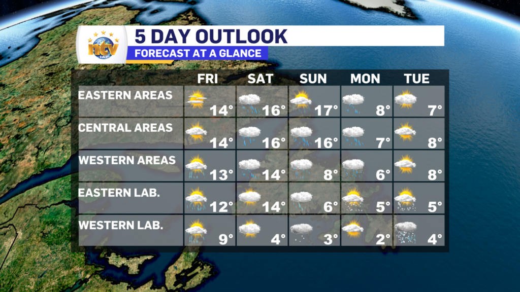
Friday will start quietly across the Province, but rain will spread into Central, western, and southern Newfoundland during the afternoon. Highs near 10°. Labrador will see sunshine Friday, with highs near 3°.

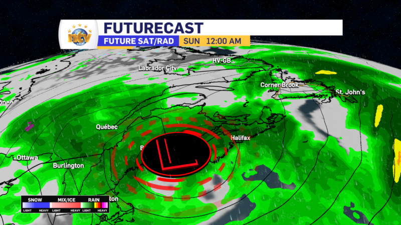
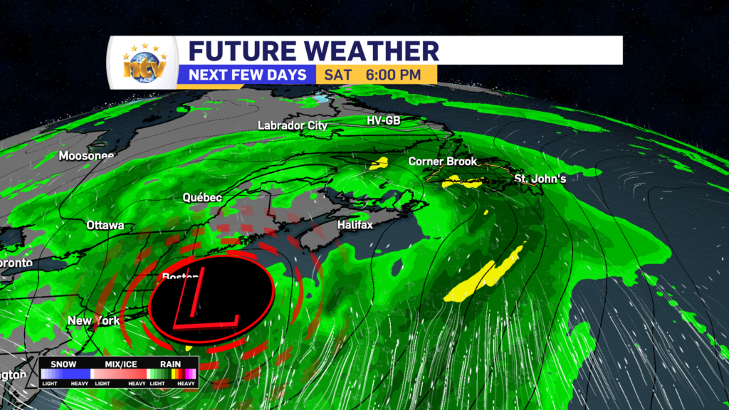
Saturday will be another rainy day on the Island, while rain and accumulating snow will fall in Labrador. At the moment, it’s still a little too early to get into snowfall amounts, however in some areas of the North Coast it does look like it will be a healthy amount. The first decent shot of the snow this season looks to be on the way.

Saturday afternoon’s forecast | Euro Model

Rain returns to Western Newfoundland Wednesday afternoon, then spreads east

TONIGHT’S OUTLOOK

Tuesday night will generally see fair weather conditions across the bulk of Newfoundland and Labrador. On the Island, we can expect partly cloudy to mostly clear skies, with low temperatures ranging from near 0° to 10°. The coolest readings will be found in Central, the warmest on the South Coast, and everywhere else will generally end up between 0° and 5°.

Labrador will see partly to mostly cloudy skies, with flurries and showers in the west. Lows of 1° to 4° will be common, with the cooler side of that range in the west and the warmer in the east.

WEDNESDAY/THURSDAY OUTLOOK

The day starts quiet and sunny over much of the Island, however, clouds will spill in throughout the day from southwest from west to east. Rain will arrive on the West Coast between 4 and 6 PM and will spread east overnight. Highs climb into the upper single digits to lower teens

The rain will end from west to east late Wednesday night and Thursday morning and will be offshore by midday Thursday. Rainfall amounts will in the 5 to 15 mm range, with up to 30 mm for parts of the West Coast.

Thursday will then see clearing conditions across the Island, with highs reaching the lower teens.

Meanwhile, in Labrador, we will see showers in the west on Wednesday, with sunny skies in the east. Highs range from 7 to 10. A cooler day is on tap for Thursday, with some flurries and/or showers in the east. Skies will be cloudy to mostly cloudy and highs will be in the 2° to 6° range.

Friday will start quietly across the Province, but rain will spread into Central, western, and southern Newfoundland during the afternoon. Highs near 10°. Labrador will see sunshine Friday, with highs near 3°.

Saturday will be another rainy day on the Island, while rain and accumulating snow will fall in Labrador. At the moment, it’s still a little too early to get into snowfall amounts, however in some areas of the North Coast it does look like it will be a healthy amount. The first decent shot of the snow this season looks to be on the way.

Saturday afternoon’s forecast | Euro Model

Tuesday’s forecast; the sunshine returns!

Our Tuesday morning is certainly starting on the chilly side of things, with readings into the single digits above and below freezing on the Island, and generally below in Labrador. Eastern and northeast areas of the Island generally see cloudy skies to start the day, and in many areas, it’s probably damp. Meanwhile, areas to the west, south, and northeast and into Labrador are generally dry.

Today, we will see a fair bit of sunshine on the Island. Areas that start cloudy, like in the east, will see increasing sunshine throughout the day. Highs reach the middle to upper single digits on the Island and across the Big Land. Labrador will also see partly to mostly cloudy skies today, with some showers or flurries pushing into the west this afternoon and evening.

After today, temperatures will generally be on the upswing for the remainder of the week. Highs on the Island will creep back into the teens and Labrador will work back into the upper single digits to lower teens. The next chance of rain will be from late Wednesday through early Thursday on the Island. Beyond that the next chance of rain on the Island will be Saturday, while Labrador will see a chance of rain and snow.

I’ll have your next forecast later today.

Have a great one!

Eddie

Parts of Newfoundland see first snowfall of the year

Southwestern, central, and interior parts of the Island are no stranger to snowfall in the fall, however, we had yet to see any this season… until today.

Multiple reports came in this morning that the higher elevated areas of southwestern and interior Newfoundland saw wet snow accumulating in some areas. The first two pictures you see are from the Burgeo Highway and the third is from North Branch.

Julie Baggs | The Burgeo Highway
Danny Clarke | Burgeo Highway
Joe Pawson | North Branch, NL

The weather will generally improve overnight and our snow threat, for the time being, has passed. On the Island portion of the Province at least.

Monday’s Outlook; Cooler for all and still rainy for some

The weather across much of the Island will not be as rainy today, compared to yesterday nor will it be as warm. However, areas of southern and eastern Newfoundland will see periods of rain and showers throughout the day, thanks to a weak area of low pressure to our south. There is also going to be some fog in the mix as well, and we are already seeing that over sections of eastern this morning, including in and around St. Johns.

Future Radar does a good job of showing where the rain is going to be today. Note it’s not going to be overly heavy, but more light and steady over areas of the south and east. This also doesn’t show cloud cover, but for today most of the Island is going to be under cloudy skies, with some breaks moving into the GNP and West Coast during the afternoon.

Temperatures are also going to be quite a bit cooler today for the Province, as a whole. Expect highs only into the middle and upper single digits. In fact, it may even be cold enough that the higher elevations of southwestern Newfoundland see wet snow today. The HRDPS model, pictured below, suggests that. If you’re heading down the Burgeo Highway today, be on the lookout for some flakage!

HRDPS model’s snowfall projections for Monday, October 23, 2023

The best weather, hands down, across the Province, today will be throughout most of Labrador, where sun and cloud will be the rule. The exception is on most of the coast, where there will be showers and/or wet snow at times today.

Rainfall Warning(s) in effect for various areas of Newfoundland this weekend

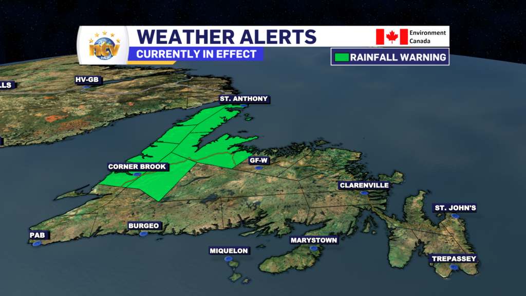
A Rainfall Warning remains in effect for much of central, western and northern Newfoundland for Sunday

Rain continues through Sunday over most of the Island

The area of low pressure that is driving the rain and gusty winds over the Island portion of the Province will be slow to pull away on Sunday. This will keep the rain on the go and gusty winds a factor throughout the day. On the plus side, by in large, the heaviest rain and highest wind speeds are done with. But the rain will continue over much of the Island into this evening, and in some cases into Monday. Future Radar times this out very well.

WEATHER ALERTS

As of early Sunday morning, a Rainfall Warning remains in effect for much of central, interior, western, and northern Newfoundland. This will likely be ended this evening, as the heavy rain threat finally ends. You can find the details on these alerts right here.

THE RAIN

While much of the Island will see showers on Sunday, western and northwestern Newfoundland areas will see the heaviest rainfall throughout the day. Inside of that, the most intense rainfall rates will generally occur early Sunday morning. The rain will end for many areas late Sunday afternoon or evening, however for southeastern Newfoundland light rain will continue through Monday in onshore, northerly flow.

Expected rainfall totals by late Sunday evening

THE WIND

The wind speeds will be gusty for our Sunday but overall should be lower than Saturday’s peaks for areas of southern and eastern Newfoundland. Areas along the West Coast will notice an uptick in speeds today, and along the coast, gusts will be as high as 70 or 80 km/h from the north-northeast.

TEMPERATURES

Temperatures will be in the teens on Saturday and Sunday, before falling to the single digits on Monday as cooler air moves in. Enjoy the warmth this weekend, because these may be the last teens we see for a good long while, based on the long-range forecast. Labrador will see cooler readings, too, over the weekend. But no major weather looks to be in play for the Big Land.

For your latest forecast and to see our live, interactive radar, be sure to visit the weather centre!

Rainfall Warning, Wind Warning and Special Weather Statements in effect for the weekend

AS OF 6:55 AM ON OCTOBER 21, 2023, THESE ALERTS HAVE BEEN ENDED OR MODIFIED. PLEASE VISIT THE HOME PAGE FOR THE LATEST WEATHER ALERTS.

A strong area of low pressure will move through the region this weekend. This promises to bring a healthy dose of rain and wind to the Island starting Saturday and lasting into Sunday. The Environment and Climate Change Canada Weather Office in Gander has issued three weather alerts, so far, ahead of this system. They are as follows…


A Special Weather Statement is in effect from Saturday through Sunday for the following areas:

  • The Avalon Peninsula Southwest
  • The Avalon Peninsula Southeast
  • The Avalon Peninsula North
  • St. John’s & vicinity
  • The Burin Peninsula
  • Connaigre
  • Corner Brook & vicinity
  • Deer Lake – Humber Valley
  • Gros Morne
  • Bay St. George
  • Buchans and the interior
  • Grand Falls-Windsor & vicinity
  • Bay of Exploits
  • Green Bay – White Bay (Baie Verte Peninsula)
  • Northern Peninsula East
  • Parson’s Pond – Hawke’s Bay
  • Port Saunders and the Straits (Northern Peninsula West)

Current details: Significant rainfall expected this weekend.

Locations: southern, western, central, northern, and parts of northeastern Newfoundland.

Total rainfall: widespread 40 to 90 mm with locally 100 mm or more possible over parts of southern, central and western Newfoundland, while eastern areas will see as much 50 mm of rain. Locally higher amounts are likely.

Wind Speeds: Wind speeds will peak from the southeast as high as 80 km/h, with gusts to 100 km/h possible over exposed areas.

Remarks: Rain is forecast throughout the weekend but latest forecast guidance suggests the heaviest rainfall will come in two waves with the first being Saturday afternoon into Saturday evening and the second late Saturday night through most of Sunday.

Similar storms in the past have caused hazardous driving conditions, pooling of water on roadways, and localized flooding in low-lying areas.

Be sure storm drains and gutters are cleared of debris.


A RAINFALL WARNING is in effect for the following area from Saturday morning thru Sunday morning:

  • Burgeo – Ramea
  • Channel-Port aux Basques

Current details: Rain, at times heavy, is expected.

Total rainfall: 50 to 90 mm, with locally heavier amounts possible.

Locations: southwestern Newfoundland.

Time span: Saturday morning to Sunday morning.

Remarks: Rainfall rates of 5 to 10 mm per hour are possible in the heaviest downpours.

Heavy downpours can cause flash floods and water pooling on roads. Localized flooding in low-lying areas is possible.

Rainfall warnings are issued when significant rainfall is expected.


A Wreckhouse Wind Warning is in effect for Saturday afternoon for the following areas:

  • Channel – Port aux Basques

Current details: Strong winds are expected or occurring.

Time span: Saturday afternoon.

Maximum gusts: southeasterly up to 120 km/h in the Wreckhouse area.

Be prepared to adjust your driving with changing road conditions due to high winds.

Wreckhouse wind warnings are issued when there is a significant risk of damaging winds.


FOR YOUR LATEST FORECAST, BE SURE TO VISIT THE THE WEATHER CENTRE BY CLICKING HERE

Eddie’s Friday AM Update; A calm day ahead

SPECIAL WEATHER STATEMENT AND A WRECKHOUSE WIND WARNING ARE IN EFFECT FOR THE WEEKEND

Good Friday morning! The date is October 20, 2023, and we are starting off the day with temperatures in the teens and single digits across NL as of 6:40 AM NDT (6:10 AM ADT).

Throughout today, we will see a decent recovery in temperatures across much of the Province as some slightly warmer air moves into the region. Highs across the Island will crawl into the teens, and much of Labraodor will see highs in the upper single digits to lower teens.

There will be some showers working through Labrador West this morning which will turn into a lighter rain. The showers and light rain will push east and arrive as far east as Happy Valley-Goose Bay this evening. There will also be showers along the West Coast and possibly onto the Baie Verte Peninsula this afternoon, too.

The forecast for October 20, 2023

The weather is going to turn a bit more stormy for the Island this weekend, and I’ll have your full breakdown on this later today on ntv.ca and this evening on NTV.

A Quiet Friday closes out the work-week

The Overview

A ridge of high pressure will keep the weather quiet and relatively calm across the bulk of the Province overnight. The same ridge will generally keep things sunny and mild for Friday, however, a few showers will skirt into Labrador and western Newfoundland at various times during the day. The next big weather-maker, which is a deepening area of low pressure, will arrive Saturday and will not depart until later Sunday. This low will bring heavy rain and gusty winds to much of the Island from Saturday mid-morning through Sunday.

A follow-up low could bring another bout of lighter rain on Monday. Temperatures will remain relatively mild through Saturday, with cooler air arriving Sunday or Monday. Highs dip into the single digits by early next week Island-wide.

Meanwhile, in Labrador, expect a quieter weekend, but a turn toward cooler temperatures by Sunday. In fact, by early next week highs will only be in the lower to middle single digits, and flurries will be widespread. This is a sure sign of the season.

The Forecast

Thursday Night: Mostly clear on the Island with lows of 6 to 12. It will be warmest o the southwest coast and generally cooler elsewhere. Labrador will see partly cloudy to mostly clear skies, with a few showers late in the west. Some areas of the west may see flurries. Lows of 2 to 7.

Friday: Mostly sunny to start the day across the Island, however, clouds increase central, west, and south during the afternoon. There may be some showers late in the day on the West Coast and on the Northern Peninsula. Highs in the lower to middle teens.

Labrador will see scattered showers, under mostly cloudy to cloudy skies. Highs of 5 in the west to 12 in the east and 8 in the north.

Saturday: Rain arrives on the Island during the late morning to early afternoon and will become heavy at times for most areas by evening. Wind speeds ramp up Saturday night and may gust to 100 km/h from the southwest during the overnight, over exposed areas. Highs on Saturday will be in the lower to middle teens.

Labrador will see mostly cloudy skies, with his of 4 in the west to 14 on the coast.

Sunday: Rain and showers will continue on the Island throughout the day. The best weather will likely be found in the east, where sunshine will be in the cards for the morning before showers return during the afternoon. Highs will be in the middle to upper teens south, central and east, while temperatures fall into the single digits in the west during the day.

Labrador will see scattered showers or flurries, with highs of 3 to 6.

Monday: Another chance of rain on the Island, with highs 6 to 8. Few flurries in Labrador under partly cloudy skies, with highs of 2 to 5.

Tuesday: Partly to mostly cloudy on the Island, in northerly flow. Highs near 7. Scattered flurries or showers in Labrador, with highs near 5.

Scroll to top