Weather

Easterly flow dominates the weather pattern this week

Over the next 5+ days, we are going to be in a weather pattern of higher than normal pressure to our north and lower than normal pressure to our south. This puts Newfoundland and Labrador in broad onshore, easterly flow. This easterly flow will keep clouds, drizzle, and fog in the picture for eastern areas of the Island and coastal Labrador, with few exceptions. As you move farther west on the Island and inland in Labrador, the weather will not be as damp, but clouds and showers will still abound.

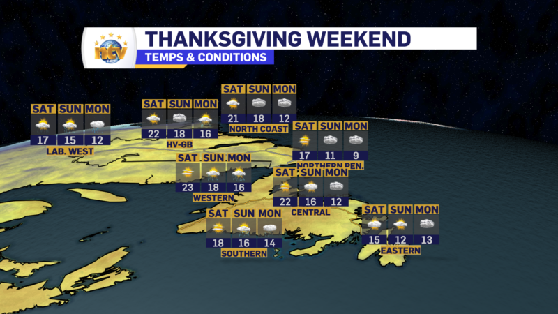
This pattern is almost “spring-like” except it will not be quite as cold in the onshore flow. Highs across most of the Island this week will be in the lower to middle teens and lows will be a few degrees lower. Fog will be common, especially on the Avalon and Bonavista peninsulas, and will be most dense at night.
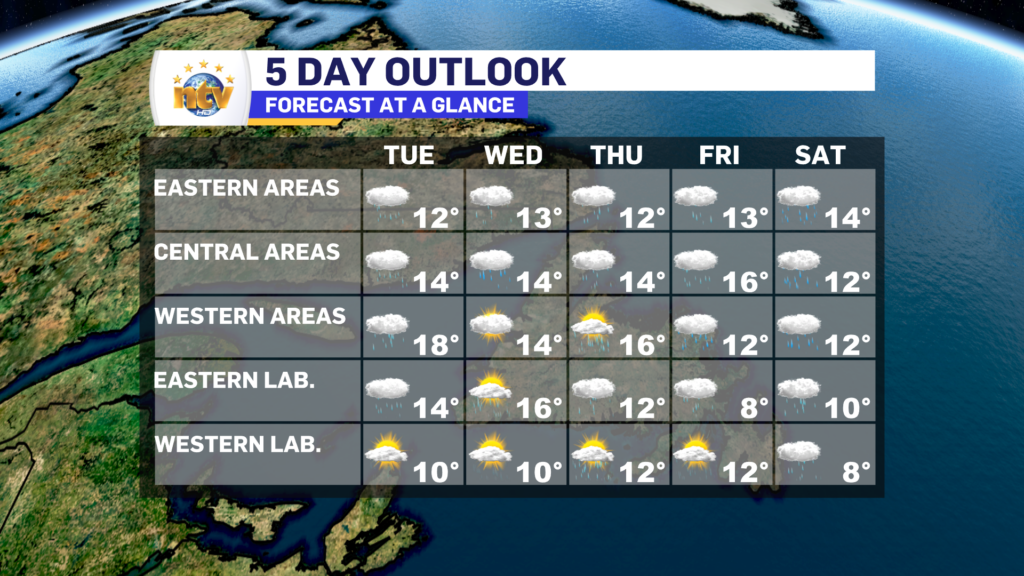
THE FORECAST

Tuesday: Cloudy on the Island with scattered showers. Drizzle and fog in the east. There may be a few sunny breaks inland. Rain moves into southwestern Newfoundland in the afternoon. Laboradr will see cloudy skies in the east, giving way to some sunny breaks west. Highs of 10 to 15.

Wednesday: Periods of showers and/or rain thru central Newfoundland, otherwise expect more clouds, drizzle, and fog across much of the Island, minus the west coast and areas along the Gulf. Those areas may see some sunshine. Highs will be in the mid-teens. Labrador will see a mix of sun and cloud, with scattered showers. Highs of 10 to 16.

Thursday: Areas of showers on the Island. Drizzle and fog in the east and some sunny breaks in the west. Highs of 12 to 16. Coastal Labrador will see drizzle and fog, along with highs near 12. Interior and western areas will see highs of 12 under mostly cloudy skies with scattered showers.

Friday/Saturday: Chance of rain on the Island, with highs near 12. Mostly cloudy in Labrador, with highs of 8 to 10.

Clouds and showers return for Monday, along with cooler temperatures

Easterly flow dominates the weather pattern on Monday, which means a return to clouds, drizzle and even fog for a large part of the Island. Highs today reach the lower to middle teens Island-wide. The warmest readings will be found in offshore flow and in areas away from east-facing shores. Showers will be found over the west and southwest coast.

Meanwhile, Labrador will also see more clouds than sun today, and showers in the west. Highs reach the lower to middle teens across the Big Land. The showers will be most widespread between Goose Bay and Labrador City.

Tuesday will be a soggier day across the Province as some rain moves through. I’ll have an update on this later today.

Stay tuned for your next update!

More record highs were set Saturday, less should be Sunday and Monday

Multiple record and monthly highs were set throughout the Big Land Saturday, and numerous locations throughout the Province reached the lower 20s under bright sunshine and surprisingly light wind speeds. Rodney Barney, a Meteorologist with the Environment and Climate Change Canada Weather Office in Gander (ECCC NL) highlighted this with a tweet.

Sunday will see the remnants of Philippe push westward into Quebec. This will generally keep the weather across NL calm, although showers will push into Labrador West this afternoon, along with southwestern Newfoundland. Temperatures today will be warm, but shouldn’t be as warm as yesterday for most areas. We can thank that to clouds scooting into Labrador, limiting highs to the upper teens to about 20, and not so much over 20.

On the Island today, we should see more sunshine over a large part of that didn’t see it yesterday. In fact, oddly enough, skies will clear from east to west today and even the Avalon should see some sunshine by later this morning. The west and southwest coast may be hard-pressed to break into the sun, however, as the cloud over this area is more related to Philippe. Speaking of Philippe, this morning Marine Atlantic Crossings are cancelled. Be sure to check with them for the evening sailings!

Futurecast, below, should time out the clouds, showers, and temperatures across the Province for our Sunday and Monday.

Have a Happy Thanksgiving!

Saturday will be unseasonably warm for virtually all of N.L., minus the Avalon

The long weekend is upon us and will start off on the unseasonably warm side for a large chunk of the Province. Friday saw numerous records fall in Labrador and on the Island, and I would suspect the same will happen today.

Temperatures yesterday, and again today, will be between 10 and 15 degrees above normal. While records in Labrador have been set before, this is pretty unprecedented stuff for this time of year, as both Goose Bay and Makkovik set their all-time October records on Friday as well. And with respect to anomalies, some of the highest is over Quebec and Labrador again today.

Temperature anomalies over North America for Saturday, October 7, 2023 | TropicalTidBits.com

Weatherwise, for Saturday, we are generally looking at partly cloudy to mostly sunny skies across much of the Province. The exception will be on the Avalon, where clouds will hang tough. Now, not all areas of the Avalon will be cloudy all day. Inland locations and places near Trinity and Placentia Bays may see some sunshine, like yesterday. Highs throughout the Province range from the mid-teens to lower 20s. The coolest readings will be found over eastern Newfoundland and the warmest over interior and western parts of the Island and up through much of the Big Land.

Saturday’s forecast for N.L – October 7, 2023

Sunday and Monday will be a tad cooler as the remnants from Philippe make their way into the region. While the impacts from those to NL will be minimal, it will drive some showers into the region and bring temperatures back to a more normal type level as we close out the long weekend and go into next week.

Thanksgiving weekend forecast for N.L. | Posted October 7, 2023

The weekend warmth continues across the Province… except in the east!

The unseasonably warm weather sticks around for the bulk of our long-holiday weekend. There will be a bit of a cooling trend as we make our way toward Sunday and Monday. I broke the forecast down in tonight’s NTV Evening News Hour

Friday AM Update; Warmer today, but clouds will hang tough for some areas

We are waking up to temperatures that are generally as warm, or warmer, than what we were seeing yesterday afternoon and evening. The warmer air mass that was in Labrador yesterday has reached the Island portion of the Province as well. Take a look at some temperatures from 6:30 AM NDT this morning.

Along with the mild temperatures this morning, we are also seeing some clouds streaming across the region, under which there are some showers. There looks to be a chance of showers in Labrador West this morning, along with the top of the Great Northern Peninsula of Newfoundland. Satellite imagery shows the clouds moving in quite well.

The cloud cover today is going to be the biggest headache in my forecast. In some areas, it will clear off during the later morning and afternoon, and in other areas, it will hold steady throughout the day. My best guess is that most of the Province, west of the Avalon, will see sunshine by early to mid-afternoon. On the Avalon, it looks like the clouds are going to hold steady today. The Future Cloud animation below shows this nicely.

Temperatures will be similar to yesterday in Labrador, with highs into the teens and 20s. Much of the Island will see the same, although in the east expect mid-teens, while any 20s will be limited to central, southern, and western areas. More records will fall.

Record highs fell in Labrador Thursday as warmer air moved into the region

An unseasonably warm air mass moved into Labrador and allowed temperatures to soar into the teens and 20s across the Big Land. To put that into perspective, the average high today through much of Labrador is between 7° and 10°, so many areas were upward of 10° above normal! This air mass looks to stick around through the weekend, and I expect more record highs to be set in Labrador over the next few days. Some of the highest temperature anomalies, meaning how high temperatures will be above normal, will be over Labrador for the next 3 to 5 days. That’s what the big red, and almost white, area represents on the map below.

Weatherwise over the next few days things look fairly quiet across the Province. Other than scattered showers, we’re not really looking at a whole lot of weather on the go until later Sunday or Monday. At that point, the remnants from Tropical Storm Phillippe will bring some showers to the region. Temperatures remain in the teens to 20s through Tuesday, although hedge more teens, and not 20s. by the second half of the weekend and next week.

FOR YOUR FULL FORECAST, VISIT NTV.CA/WEATHER AND PLUG IN YOUR LOCATION!

Speaking of Phillippe, the system is fairly disorganized and will head north over the next few days. At this time it looks to arrive in Nova Scotia late Saturday or early Sunday as a post or sub-tropical system and it will merge with a trough over the eastern parts of the US and Canada.

A Special Weather Statement has been issued by Environment Canada for NS, NB, and PEI for the Saturday afternoon through Sunday afternoon time frame. Some rain and wind are expected, but at this time this looks to resemble and strong fall storm and not a strong tropical system. Impacts should be less significant than what Lee brought a few weeks ago.

The warmup continues today across N.L.

Thursday will see a few early showers in eastern Labrador and on the Avalon, otherwise, it’s a mix of sun and cloud across most of the Province. Temperatures recover nicely after the chilly start for some locations on the Island and reach the mid-teens to lower 20s across the board. The warmest air will be found over the western parts of the Big Land.

Friday will see even warmer temps on the Island and Saturday will be similar. Widespread highs in the upper teens to lower 20s are likely and I suspect some records will be broken.

Sunday into Monday may see the remnants of Tropical Storm Phillippe working into the region. At this point, impacts to NL look to be mainly rain, while our Maritime neighbors will see more significant amounts of rain, wind, and high waves. This forecast will evolve and get clearer over the next couple of days.

The warmup starts tonight in Labrador, Thursday on the Island!

A warm front will push across Labrador overnight into early Thursday morning. This will send warmer air into the Big Land overnight, sending temperatures upwards in the West overnight. In fact, by Thursday morning it’ll be warmer than what is now for areas like Labrador City and Churchill Falls. Meanwhile, eastern Labrador and the Island will see a chilly night. With many areas on the island falling near, or below the freezing mark.

Thursday will see a few early showers in eastern Labrador and on the Avalon, otherwise, it’s a mix of sun and cloud across most of the Province. Temperatures recover nicely and reach the mid-teens to lower 20s. The warmest air will be found over the western parts of the Big Land.

Friday will see even warmer temps on the Island and Saturday will be similar. Widespread highs in the upper teens to lower 20s are likely and I suspect some records will be broken.

Sunday into Monday may see the remnants of Tropical Storm Phillippe working into the region. At this point, impacts to NL look to be mainly rain, while our Maritime neighbors will see more significant amounts of rain, wind, and high waves. This forecast will evolve and get clearer over the next couple of days.

Wednesday will feel very much like fall across the Province

Good Wednesday morning!

A cold front moved through the Province on Tuesday and behind it, we’ve got a very fall-like air mass working its way in. As of 6:30 AM NDT temperatures across the Province are generally in the lower to middle single digits. Northerly winds have taken over behind the front and an area of high pressure is located over western Labrador and eastern Quebec.

The weather across the Province today will generally be partly cloudy, a tad breezy and cool. Highs will only be in the mid-single digits to about 13º or 14º. While most areas will see the wind speeds coming down throughout the day, eastern areas may see it creep up a bit as the pressure gradient between an offshore low and the Quebec/Labrador high tightens a bit.

We will see a gradual return to warmer temperatures tomorrow and Friday. And then our attention will turn to Tropical Storm Philipe which looks like it may impact the weather across the Maritime Provinces later this weekend (Sunday). While it looks like impacts to NL will be limited, this still needs to be watched closely. Still a little early to get into impacts, but assuming the track is toward NS, the normal tropical influences will be felt; wind, rain, and high seas.

Scroll to top