Weather

Wednesday night’s forecast; rain moves into Labrador while it’s status quo on the Island

The Overview

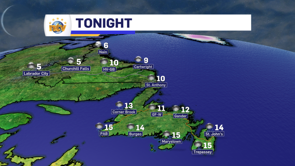
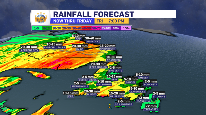
An area of low pressure will swirl its way toward Labrador overnight and will spread rain throughout much of the Big Land before sunrise Thursday morning. The exception will be on the coast, where the rain will hold off until post-sunrise.

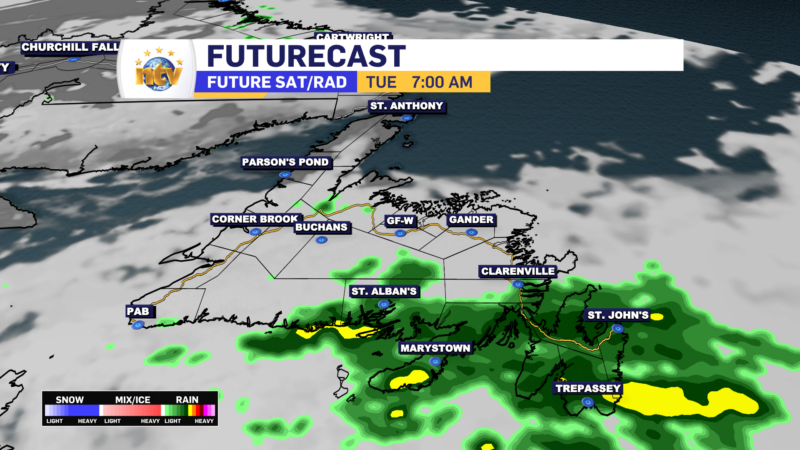
On the Island, the large area of high-pressure offshore will keep the easterly flow going overnight. Due to that being the case, cloudy skies will be the norm, with areas of drizzle and fog along and near east-facing shores.

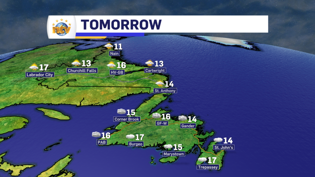
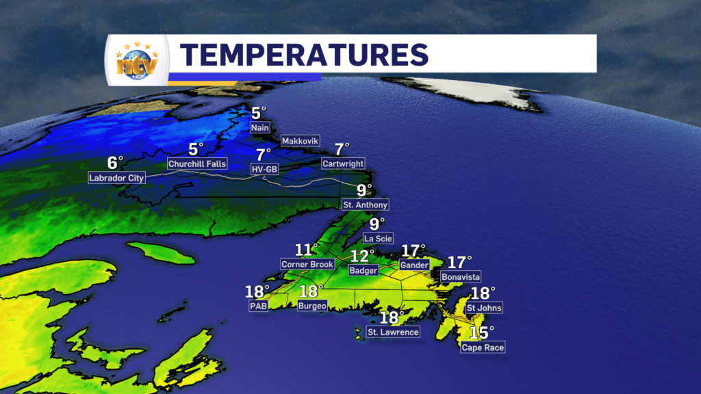
Lows on the Island will be in the lower to middle teens. Labrador will see lows of 5 to 10.

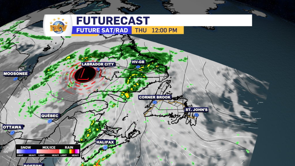
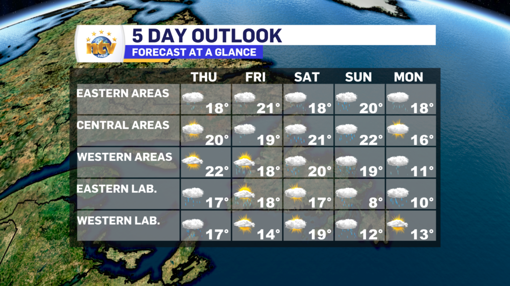
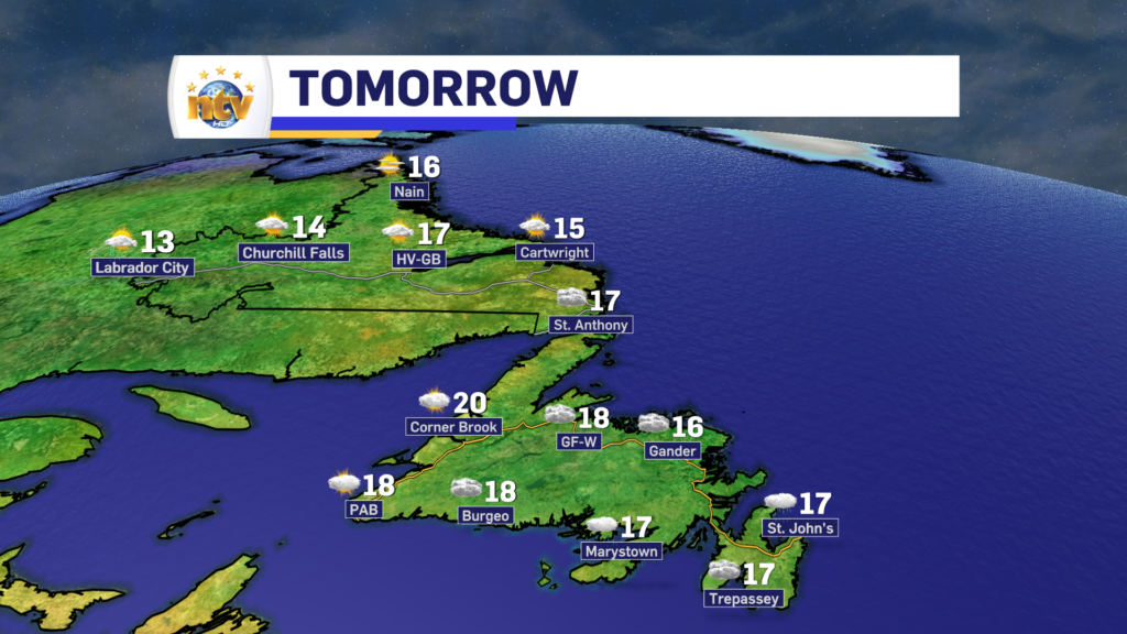
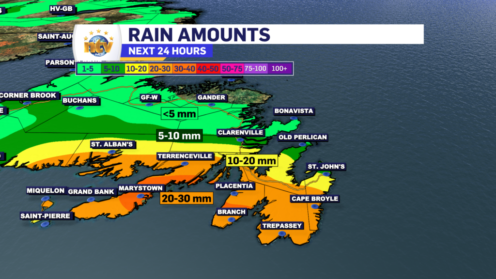
The area of low pressure will continue its journey through Labrador tomorrow and more rain will fall across the area. There may even be some isolated thunderstorms near, and east of, the low. Highs in the Big Land range from 13 to 17.

The winds will turn a bit more southerly on the Island tomorrow, which will allow for a shift in the fog and drizzle to southern shorelines, although eastern areas will likely still see some of it. Clouds will be the rule. once again. Highs will be in the upper teens to near 20°.

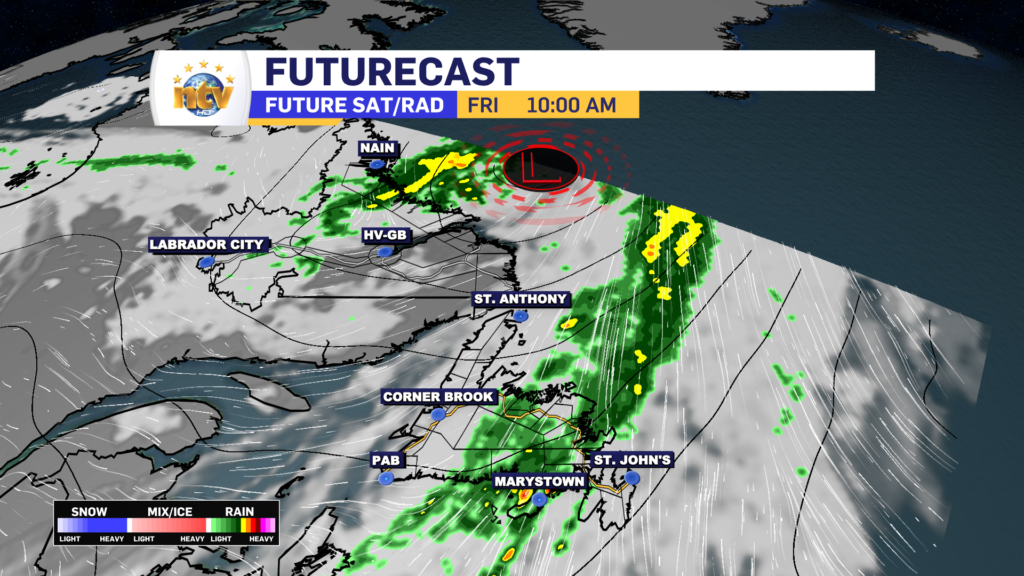
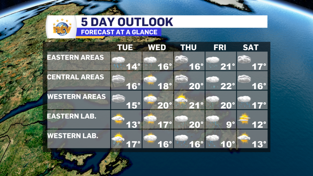
Friday will see the rain taper off in Labrador by mid-morning, while the Island will see rain through much of the day from a narrow band. That band will depart the west coast in the morning but will keep the rain ongoing through Central and Eastern into the afternoon. Highs creep into the lower 20s and sunshine will be hard-pressed to be found. Labrador will see highs in the middle to upper teens.

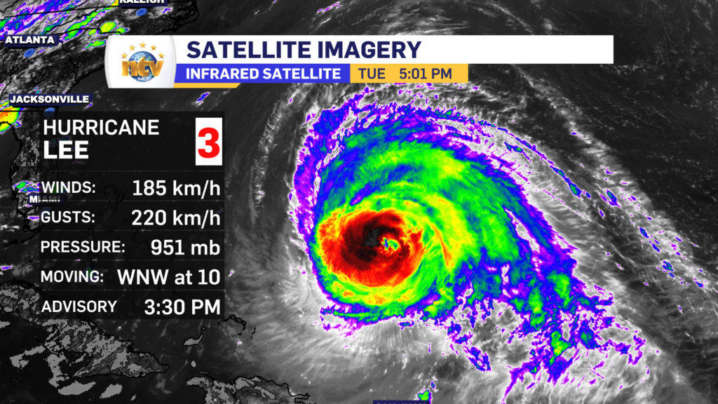
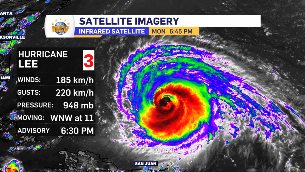
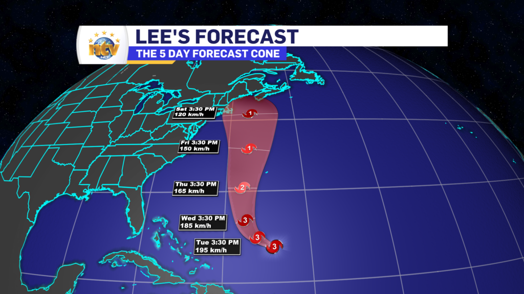
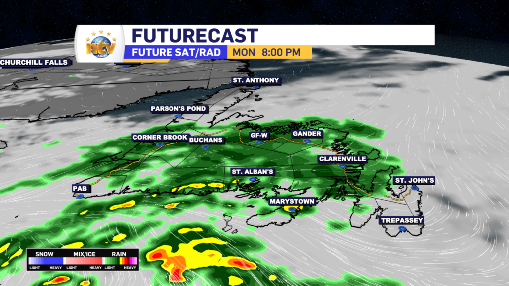
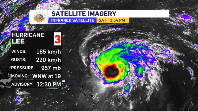
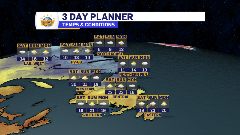
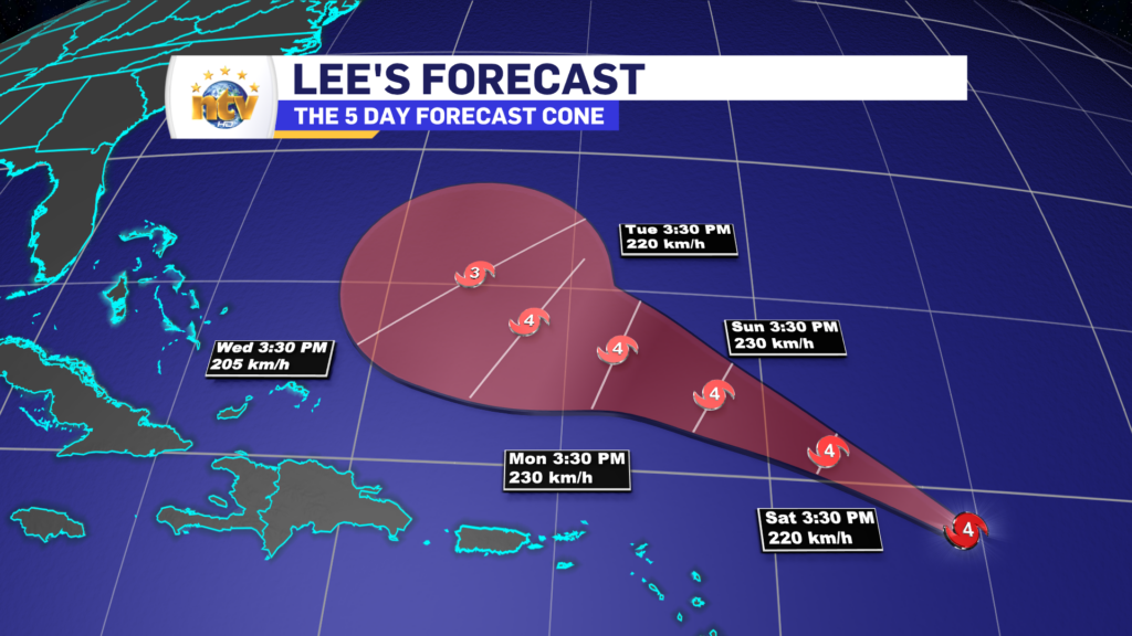
Temperatures won’t move much for the weekend, and rain is in the forecast for much of the Province as the remnants from Hurricane Lee make their approach.

I’ll have an update on Lee posted to ntv.ca shortly and will link to it in this story once its up!

Wednesday morning’s forecast; more of the same

An area of high pressure north of the Island is going to keep the onshore, easterly flow, on the go for the next couple of days. While this will not result in significant weather rolling into the Island, it will keep the skies cloudy, drizzle frequent, and fog possible along and near east-facing shorelines.

Today will be similar to today across the Island. We can expect more showers, clouds, drizzle, and fog thanks to the onshore flow. Highs will be in the middle to upper teens. There may be some sunny breaks on the West Coast and southwest coast, and the western side of the GNP.

Labrador will see a decent day, with highs in the middle teens under sun and cloud. There will be some showers in the west late in the day.

NL Forecast for today, September 13, 2023

Looking into Thursday and Friday, the weather generally doesn’t change a whole lot on the Island as the wind direction remains the same. There will be some rain in Labrador on Thursday and potentially again in the west on Friday. Highs remain in the teens and may creep toward the 20s in some areas to close out the work week.

Eddie’s forecast: More clouds than sun will be the rule for Wednesday + an update on Hurricane Lee

An area of high pressure north of the Island is going to keep the onshore, easterly flow, on the go for the next couple of days. While this will not result in significant weather rolling into the Island, it will keep the skies cloudy, drizzle frequent, and fog possible along and near east-facing shorelines.

Lows will be in the lower to middle teens on the Island overnight, and areas of drizzle will be common for most areas, but it’ll be most prevalent along and near east-facing shores. Fog will also be around too.

Meanwhile, in Labrador, expect partly cloudy skies and lows of 6 to 10 tonight.

NL forecast for tonight, September 12, 2023

Wednesday will be similar to today across the Island. We can expect more showers, clouds, drizzle, and fog thanks to the onshore flow. Highs will be in the middle to upper teens. There may be some sunny breaks on the West Coast and southwest coast, and the western side of the GNP.

Labrador will see a decent day, with highs in the middle teens under sun and cloud. There will be some showers in the west late in the day.

NL Forecast for tomorrow, September 13, 2023

Looking into Thursday and Friday, the weather generally doesn’t change a whole lot on the Island as the wind direction remains the same. There will be some rain in Labrador on Thursday and potentially again in the west on Friday. Highs remain in the teens and may creep toward the 20s in some areas to close out the work week.

As we look ahead to the weekend, all eyes will shift to Hurricane Lee, which as of this writing, is still a category 3 hurricane about 900 km south of Bermuda.

Hurricane Lee Stats as of 3:30 PM NDT on September 12, 2023

Lee will turn north in the next 24 hours and begin to gain latitude, accelerate in speed, and lose strength as it leaves the warmer waters behind. Current indications are that Lee will track to the north and make landfall late Friday or early Saturday anywhere between Nova Scotia and Maine.

While there is agreement on where the storm is going to go, to a point, we still don’t know where it will go and thus where the highest winds, heaviest rain, and highest waves will be. All of that will determine where the greatest risk for flooding and power outages lies. That will get more clear in the next couple of days.

What I do know is that NL looks to be outside of the direct impacts from the system, for the time being. It does look like we may see some rain and gusty winds from Sunday into Monday and the remnants pass over the Province. However, and again at this time, this should be nothing out of the ordinary for the Province.

Stay tuned for more updates.

A soggy Tuesday is on tap for southeastern Newfoundland, and everywhere else… not so much

Our Tuesday morning is certainly starting off on the soggy side for the Avalon and Burin Peninsulas. The rain is falling heavily over the Avalon as of this writing (6:43 AM NDT) but is lighter farther west onto the Burin Peninsula. Rainfall amounts overnight were highest on the Boot. Winterland is reporting 13.3 mm since last night.

Radar imagery as of 6:46 AM NDT shows the heaviest rain over the northeast Avalon. The rain is heading east.
Radar snapshot as of 6:46 AM NDT on September 12, 2023

The rest of the day will generally see the rain persisting over the Avalon and Burin Peninsulas, although it should be a bit lighter than it is this morning. The Connaigre Peninsula and parts of the South Coast will also see the rain today.

Meanwhile, the rest of the Island will see predominately cloudy skies today, except on the GNP, where some sunshine will be found. Highs will be in the teens.

Labrador will also see a mix of sun and clouds through most of the day, however, some showers roll into western areas this afternoon and may arrive in Goose Bay by evening.

Eddie’s Monday evening forecast; rain continues into Tuesday in the southeast + an update on Hurricane Lee

A frontal boundary is going to get situated over southeastern Newfoundland tonight and linger in the area through Tuesday. Ahead of this boundary, rain is falling this evening over much of the Island south of the Great Northern Peninsula. The rain will over western and central areas overnight but will continue in the east and southeast. In fact, in those areas, the rain will continue until Tuesday before ending. Rainfall amounts from the Connaigre Peninsula to the Avlaon will total 20-30 mm in some areas, by late Tuesday.

While eastern Newfoundland will see the rain continue for Tuesday, the rest of the Island will generally see cloudy skies. Except on the GNP, there it will be partly to mostly cloudy. Labrador will also see a mix of sun and cloud for Tuesday, with some showers working their way into the west during the afternoon.

High temperatures across the Province will be in the teens for the second day of the work week.

Beyond tomorrow, the weather this week across much of the Province looks to be cloudy and unsettled, with chances for rain and showers through Saturday. Temperatures remain in the teens to lower 20s and the primary wind direction remains from the east nor northeast.

Hurricane Lee Update

As of 6:30 PM NDT, Hurricane Lee is a category 3 hurricane on the Saffir-Simpson scale, with sustained wind speeds of 185 km/h. The storm is heading west-northwest at 11 km/h and will generally maintain that course through Tuesday before making a turn to the north.

At this point, the forecasts are keeping Lee on a northerly track through Saturday, and current projections have the centre of the storm anywhere from Cape Cod to western Nova Scotia by Saturday afternoon. Keep in mind, the width of the cone above indicates where the centre of the storm will be, not the size of it.

At this time it it is still too early to talk about potential impacts, but you can expect high waves, rain, and wind to be approaching the region next weekend. Where each will be set up is still unknown but that will get clearer over the coming days. Stay tuned!

Monday’s forecast; Cloudy and drizzly on the Island, while Labrador sees a pretty nice day

The morning is starting off cloudy and a bit foggy for the Island, as northerly and onshore winds have taken hold. Throughout the day, that will not change much… in fact, rain will spread across the Island from southwest to northeast later today and this evening. This is due to a weak frontal boundary lifting north, over the Island.

Meanwhile, in Labrador, expect a mix of sun and cloud today, with highs in the teens. Pretty straightforward forecast for the Big Land!

I’ll have your next update later today!

/Eddie

Eddie is monitoring Hurricane Lee closely, however, it is still not known if the storm will impact the region

Hurricane Lee is still swirling north of the Caribbean Island this afternoon but is a bit of a weaker storm. The latest analysis from the National Hurricane Centre in the US shows winds of speeds of 185 km/h, making the storm a category 3 on the Saffir-Simpson scale. The storm is still heading toward the west-northwest at 19 km/h and will generally remain on that trajectory for the next few days. Some fluctuations in strength are likely to occur as the environment for the storm isn’t ideal.

After Tuesday, Lee will start to get pushed north as the atmospheric steering currents begin to force it that way. Once it makes the shift, the storm will likely hold, or start losing intensity, as the forward speed increases during the mid part of next week.

Beyond 5 days, no matter what you’re seeing today, it’s still too soon to get into specifics on where Lee will go. As of this writing (4:02 PM NDT) a wide variety of solutions are still on the table that could take the center of the storm anywhere from New England (Northeast USA) to Newfoundland or even the Grand Banks and anywhere between.

Once the storm starts to make the turn, and we can see how it will interact with another weathermaker swinging out of the eastern United States, I will have a better idea of where it’s going to go. Keep in mind that’s still 5 days from now, and any impact to our region, if it happens, will be about a week from now.

Please continue to monitor forecasts and updates on the storm.

The weekend forecast; we’ve had better.

The weather across the Province be half not-so-good on Saturday and half-decent for some areas on Sunday. Our Saturday will see areas of rain pushing through Labrador, and even some snow in the higher elevations of the North Coast. While on the Island, predominantly cloudy skies will be the rule, with areas of showers on the West Coast, GNP, and into parts of Central. Highs range from the lower teens in Labraodr to middle teens to nearly 20 on the Island. The warmest readings on the Island will be in southeastern areas.

Sunday will see a decidedly quieter day across the region, with cloudy skies remaining more of the rule than the exception. Although we should see some sunny breaks in spots for the second half of the weekend. Highs range from the teens in Labrador to the upper teens to nearly 20 on the Island.

Next week looks fairly normal, weather-wise with some chances for rain, again, on Tuesday. Beyond that, it looks decent enough.

Hurricane Lee's 5 day forecast cone. The storm will remain strong and track north of the Caribbean Islands before slowing

All eyes are on Hurricane Lee, but it’s too early to get into any specifics on the right now. We just need to watch and the forecast will get a bit more clear early next week. If it does end up coming our way, the timing looks like late next week or next weekend. if I need to start talking about hazards and impacts that would happen during the second half of next week.

Have a great weekend.

Eddie

Friday’s Forecast; A tale of two seasons in N.L.

Friday is starting off with areas of showers on the Island and a large area of rain in Labrador. This is to do with a weak area of low pressure swirling toward southeastern Newfoundland, and a stationary front hanging over Central and southwestern Newfoundland this morning.

The stationary boundary is one that doesn’t move, hence the name, and normally separates cooler air from warmer air. And that’s exactly what it’s doing on the Island this morning. East and south of the front it’s warm, and west and northwest of it, it’s cooler. The temperature map from 6:30 AM NDT shows this rather well.

Temperatures across NL this morning as of 6:30 AM NDT. Cooler north, with single digits and warmer south, with temps in the teens.
Temperatures as of 6:30 AM NDT / 6 AM ADT

Today will see more rain across southern Labrador, along with areas of showers over the Island. As the area of low pressure moves northeast of the Island, the stationary front will eventually move farther east and south. However, areas of southern and eastern Newfoundland will generally remain in the warm and humid air today. While areas farther north and west will get into some northerlies, which will knock readings down into the teens. It will be a nice respite from the late-season heat.

Have a great day and stay dry!

Eddie

Some areas of the Island turn cooler for Friday, as clouds, showers, and rain hang around the N.L.

What’s left of Idalia will swing across the Island overnight into early Friday, before moving offshore. This will drive more showers on the Island into the overnight period, along with the risk of isolated thunderstorms. The showers become a little less widespread for Friday as winds turn northerly for the western 2/3 of the Island. That will also signal a cool down, with highs reaching the middle to upper teens. However, in the east and south, we will not be as lucky. Another day of warm and humid weather is on tap, with mostly cloudy to cloudy skies.

Labrador will see the rain stick around overnight and Friday, with temps holding in the upper single digits to lower teens.

The weather pattern remains active through the weekend and I break your forecast down in the video at the top of the post.

Have a great night!

Eddie

Scroll to top