Weather

Hurricane Lee is poised to become a major hurricane in the next 24 hours

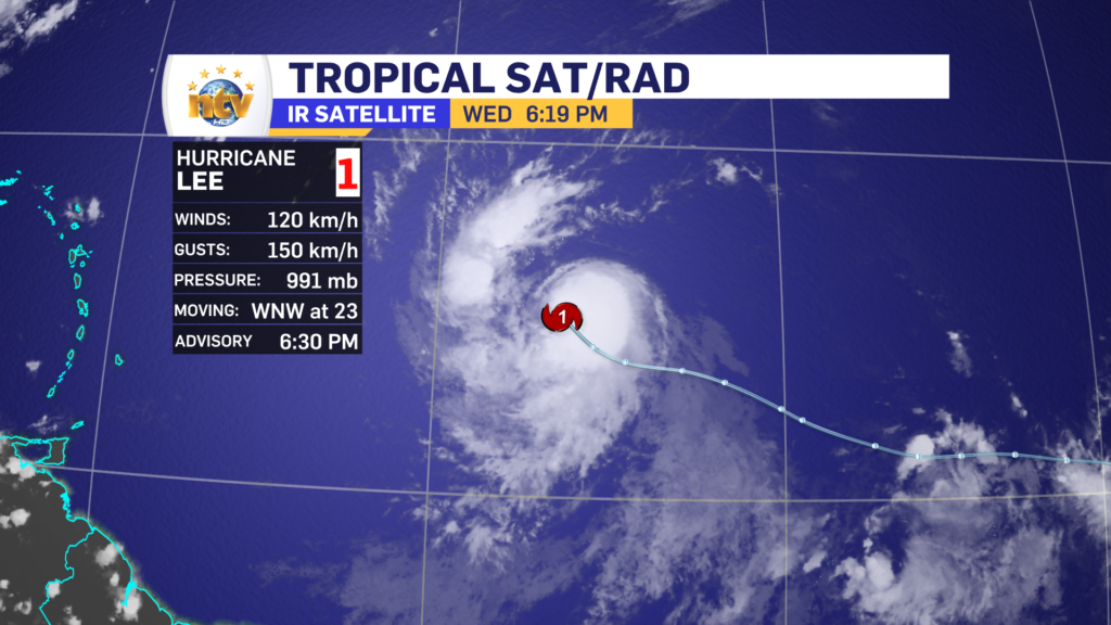
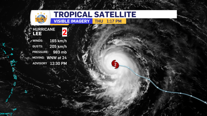
Hurricane Lee is rapidly strengthening this afternoon and is now a category 2 storm on the Safer-Simpson scale and packing maximum sustained winds of 165 km/h. The storm is heading west-northwest at 24 km/h and the central pressure is 983 mb and falling. The storm is located 1405 km east of the northern Leeward Islands.

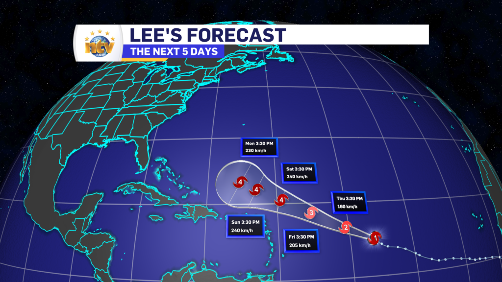
The 5-day forecast track for Lee continues to show the storm maintaining a west-northwest track, north of the Caribbean Islands. The storm will also become a large and extremely dangerous hurricane during that time frame. And will likely be the first category 5 storm in the Atlantic Basin this year.

Hurricane Lee's forecast track. The storm will be a major storm and will track north of the Caribbean Islands over the next 5 days.
Hurricane Lee’s forecast track

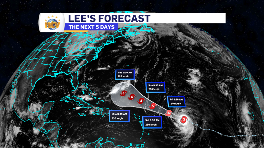
Beyond the 5-day forecast, there is relatively good agreement Lee will make a turn toward the north and eventually the northeast and will start to lose its punch as it leaves the warmer waters.

The ensemble plots for Hurricane Lee show a wide envelope of possible outcomes from the Grand Banks to New England
Canadian Model Ensemble tracks for Lee

At this point it is too soon to say if the storm will impact Atlantic Canada late next week, however, it is something we need to monitor closely. The image above currently shows a wide range of options from the Grand Banks to New England.

Stay tuned for further updates.

Thursday morning update; another muggy day for the Island, not so much in Labrador

Before we speak about Thursday, let’s delve into Wednesday a bit. Wednesday is warm hot and humid across the entirety of the Province. Multiple areas had highs in the upper 20s to lower 30s as temperatures ran more than 10º above normal in some areas!

On top of that, over the last couple of days, we’ve set some all-time September record highs in a few spots across Newfoundland and Labrador.

Now for today… that warm party is over in Labrador as a much colder air mass moved in overnight. Temperatures fell sharply and much of the Big Land is waking up to reading in the lower teens this morning. Check out the loop of temperatures over the last 24 hours.

Thursday across the Province will see rain over much of the Big Land and cooler temperatures. While on the Island we see areas of showers and thunderstorms, along with another warm and humid day. Highs should be in the lower to mid-20s, but if we get more sun than I think we are going to, mid to upper 20s are possible once again. Futurecast (below) should show this well.

There is a chance of thunderstorms today across much of the Island, particularly for areas west of Grand Falls-Windsor to near Corner Brook.

I’ll have a more detailed weather update this afternoon!

Have a great day!
Eddie

Eddie’s forecast; Rain and cooler temperatures for Labrador, while thunderstorms are in the forecast for the Island. Also, Lee is now a Hurricane

Newfoundland Overview

Showers become more widespread across the Island overnight as we see an increase in moisture from the remnants of Gert spinning to the east of Nova Scotia and south of Newfoundland. Low dip into the upper teens to near 20 overnight. Expect areas of fog along southern shorelines.

Thursday will see widespread showers across the Island, with highs in the lower to middle 20s. Humdex values will again be in the upper 20s to low 30s. The exception will be on the GNP, where some cooler air moves in, and highs will be into the upper teens.

There will also be the risk of thunderstorms across the Island on Thursday, with the best chance being between Grand Falls-Windsor and Corner Brook. Any storms will produce locally heavy rainfall and potentially gusty winds.

Labrador Overview

A cold front pushes through Labrador overnight and that will bring rain to the north and west, and much cooler temperatures across the board. Lows by tomorrow morning reach the 7 to 10 range. A far cry from today’s upper 20s to lower 30s!

Tomorrow will see rain pushing into the southeast, while the rain ends in the morning in the north and west. There may be some break of sun in the north and west. Highs will be near 10°. That’s right… about 20° cooler than today!

LEE UPDATE

As of this writing, Less is a category 1 Hurricane in the tropical Atlantic. The storm is packing winds of 120 km/h and is heading toward the west-northwest at 23 km/h.

Lee is going to become a large and dangerous category 4, or higher, hurricane by the weekend. And the 5-day track shows the storm will maintain this west-northwest trajectory.

Beyond that, the forecast is quite uncertain. However, some guidance does indicate the storm could be near our region, in a weaker state, between 8 and 10 days from now. While it’s far too early to get into any specifics, it’s a good idea to keep an eye on this storm for the time being.

The muggies make a return for Wednesday, as do the showers

Good Wednesday morning! And for parents and kids, welcome to the 2023/24 School Year!

As what’s left of Gert, spinning east of Nova Scotia this morning drifts a little more to the west, the wind direction across the Island will turn more southerly over the Island, compared to eastern and northeasterly on Tuesday. This will cause a few things to happen;

  • We will see the showers and fog shift from the east coast to the South Coast of the Island
  • The air will turn significantly more muggy as we are getting into an airmass that has Florida origins.

Humidex values over a large part of Central and eastern Newfoundland will cruise into the upper 20s to lower 30s today.

Even though the calendar says September, it’s still going to feel like the Dog Days of Summer.

Labrador will see very warm temperatures today as well, with highs across the region soaring into the middle and upper 20s.

The air over the Big Land will be unseasonably warm with highs running over 10ºC above normal in some areas!

This will not last, however, as a cool down is on the way for later tonight and tomorrow as a cold front sinks southward. I’ll have a further update on this, and Tropical Storm Lee for you later today.

Have a good one!

Eddie

Will be feelin’ like summer on the first day of school

The remnants of Tropical Storm Gert are spinning south of Newfoundland and east of Nova Scotia this evening. That is driving broad, easterly flow, across much of the region today. That setup has brought fog to eastern sections of the Island, while the West Coast, Southwest Coast, and much of Labrador have seen sunshine and highs in the middle to upper 20s, to near 30°!

For tonight we will see scattered showers around this low on the eastern and southern side of the Island. Otherwise, we can expect almost clear skies across the Province. Lows will be into the middle teens on the Island and lower to middle teens in Labrador.

Wednesday, the first day of school in the 2023 school year, will see morning showers in eastern Newfoundland shift toward the south and southwest coast in the afternoon as the wind direction turns from easterly to southerly. Expect highs on the island int he 20 to 26 range, with the coolest readings being found south. It will also be muggy, with humidex values approaching the upper 20s to lower 30s in some areas. Labrador will see highs in the middle to upper 20s, however, clouds will be on the increase in the north and west during the afternoon as a cold front begins to approach the area.

Thursday will see more showers on the Island, along with some sunny breaks and the odd thunderstorm possibility as well. Highs reach the lower 20s. Labrador will see a cooler day, with periods of rain throughout. Highs in the lower teens.

Friday will see showers over parts of the Island, with cooler highs in the middle teens to lower 20s, as the wind turns northerly. Again expect more clouds than sun. Periods of rain will be found in Labrador West.

The weekend, at this point, looks like much of the same.

What are Fallstreak clouds and how do they form?

Yesterday my social media was inundated with pictures of a fallstreak cloud, or hole punch cloud, seen over western parts of the Avalon Peninsula. Along with that, I was asked the question, how do these form? Well… let’s get into it!

Hayley Cram | Green’s Harbour, Trinity Bay

The formation of high-altitude fallstreak clouds is a product of intricate atmospheric processes. Let’s delve into the step-by-step journey of how these captivating cloud formations come to life:

  • Supercooled Water Droplets: Fallstreak clouds typically form in layers of altocumulus or cirrocumulus clouds that contain supercooled water droplets. Supercooled water remains in a liquid state even when its temperature drops below freezing, a critical factor in the formation of fallstreak clouds.
  • Ice Nucleation: Under specific atmospheric conditions, supercooled water droplets can spontaneously freeze. This process is known as ice nucleation, and it marks the starting point for the creation of fallstreak clouds. Tiny ice crystals begin to form within the supercooled cloud layer. This can often happen after an airplane passes through the area. Supercooled water is extremely unstable and any agitation may lead to nucleation.
  • Growth of Ice Crystals: Once ice crystals emerge, they rapidly grow and multiply. This growth process happens at the expense of the surrounding supercooled water droplets. As more water molecules freeze onto the ice crystals, they become larger and heavier.
  • Formation of Fallstreak: As ice crystals continue to grow, they reach a point where they are too heavy for the surrounding air to support. Consequently, they start to fall from the cloud layer, creating a distinct hole or gap in the cloud deck. This is the defining feature of a fallstreak cloud.
  • Virga: As the ice crystals descend, they often evaporate before reaching the Earth’s surface, giving rise to another phenomenon known as virga. Virga appears as wispy, streaky tails extending downward from the base of the fallstreak cloud toward the ground.
Twitter / @Ricia17 | Bellevue Beach

Fallstreak clouds, with their hole-punched appearance and radiant skies, serve as a testament to the complexity and beauty of our atmosphere. While they may not grace our skies every day, they remind us of the endless wonders of nature and the intricate processes governing meteorology. So, the next time you gaze up at the sky and spot a fallstreak cloud, take a moment to appreciate the remarkable science and artistry that come together to create these fleeting masterpieces in the heavens.

Gert’s remnants make for a soggy day in parts of the Province

Good Tuesday morning! The remnants of Hurricane/Tropical Storm/Tropical Depression Idalia are spinning to our south this morning. It’s not currently being monitored by either the National Hurricane Centre in Florida or the Canadian Hurricane Centre in Halifax. This means, at this point, both organizations are looking at it like it is a standard low-pressure centre, which it is at this point.

You can see the circulation spinning, clearly, in the waters south of Newfoundland and Labrador, and it’s backing into the Maritime Provinces. This setup will primarily drive easterly flow across much of the region today. Which will result in cloudy skies and cool temperatures for most of the Island, east of the west coast and south of the GNP. Those 2 areas should see sunshine today, along with much of Labrador.

High today will be into the teens to 20, even with the easterly flow into the region. The HRDPS model does a good job of showing that.

Something else of note is that there will be high waves along and near southern shorelines of the ISland for the next couple of days. Waves just offshore are predicted to be 2 to 3 meters. This may result in higher than normal tides and locally high water for some communities.

The high waves will last through Wednesday before subsiding on Thursday.

Have a great day!

/Eddie

Monday’s forecast; More of the same to close out the holiday weekend

Our Monday will see more of the same, as we close out the new work week. Expect mainly sunny skies across the Province, with highs in the upper teens to mid 20s. The image below does a good job of illustrating the expected high temperatures.

Beyond that, the remnants of Tropical Storm/Hurricane Idalia will move into the region beginning Tuesday. What is left of it will generally work into the Maritime Provinces. It’ll be a weak system and dissipating as it works towards Nova Scotia.

For Newfoundland, the only thing this will do is generate easterly flow as it moves into the waters south of the Island. This means that cooler temperatures, clouds, and showers can be expected for a good bit of the Island beginning on Tuesday and last through Wednesday. Expect highs in the teens.

Labour Day weekend weather looks great!

There are very few forecasts I get to write up for Newfoundland and Labrador that require very little explanation, however, the forecast for the next 3 days is just that!

Expect mainly sunny skies and temperatures into the upper teens to lower 20s on the Island through Monday, and even beyond. While in Labrador temperatures will also be in the teens to lower 20s, but showers will pop up at various times over the next few days. Outside of the showers, expect partly cloudy skies.

Have a great weekend!

/Eddie

Frost Advisory in effect tonight for parts of Central and Eastern Newfoundland

The Environment and Climate Change Canada Weather Office in Gander has issued a FROST ADVISORY for the following areas:

  • The Avalon Peninsula North
  • The Avalon Peninsula Southeast
  • The Avalon Peninsula Southwest
  • St. John’s & vicinity
  • Buchans and the interior
  • Grand Falls-Windsor & vicinity

The Frost Advisory is in effect for tonight and will expire Saturday morning as temperatures rise from their overnight minimums.

Time span: early Saturday morning.

Remarks: Patchy frost is expected to form as clear skies and light winds coincide with cool temperatures, especially in low lying areas.

Cover up plants, especially those in frost-prone areas. Take preventative measures to protect frost-sensitive plants and trees.

Frost advisories are issued when temperatures are expected to reach the freezing mark during the growing season, leading to potential damage and destruction to plants and crops.

Scroll to top