Weather

Friday’s forecast; Sunny for most areas… eventually. The long weekend looks great!

Good Friday morning!

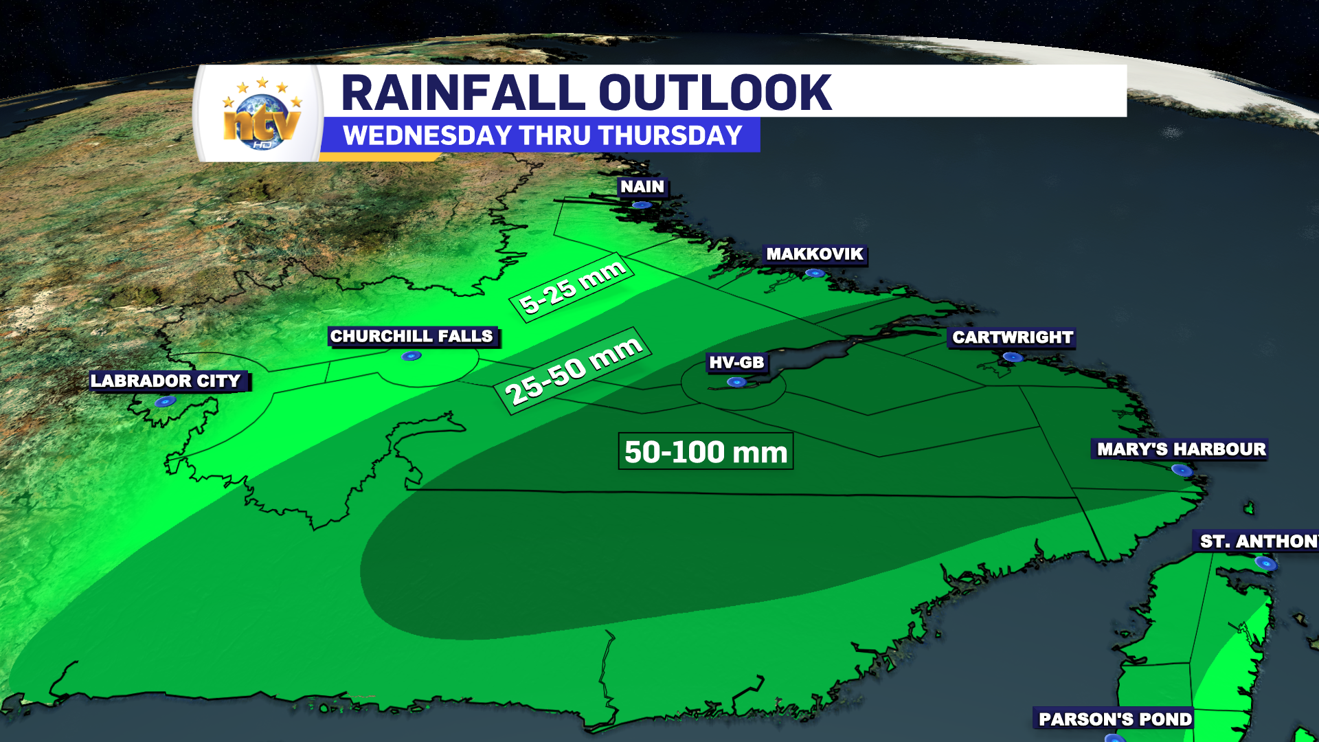
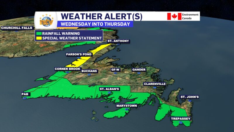
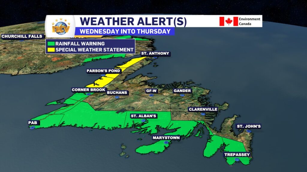
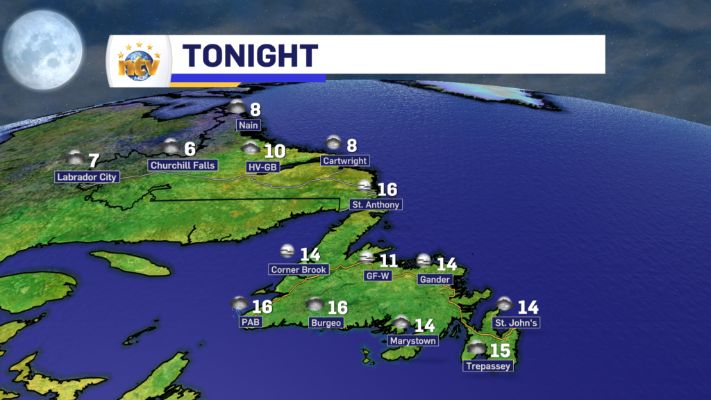
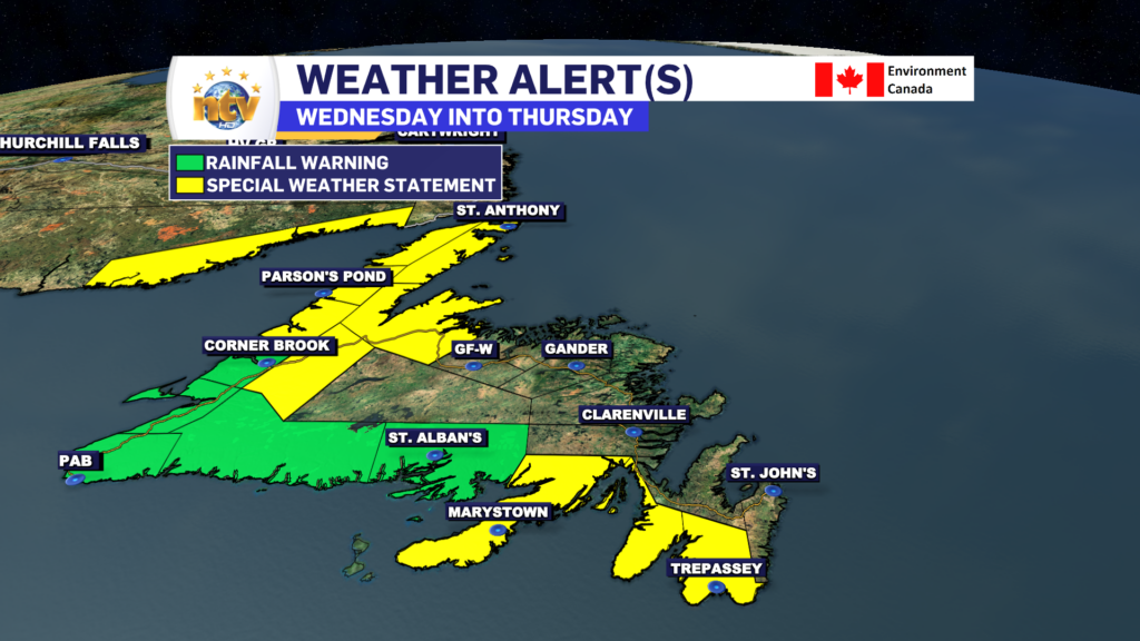
The weather across the Province will be a lot less active today. And for many areas of the Island, it will be significantly cooler.

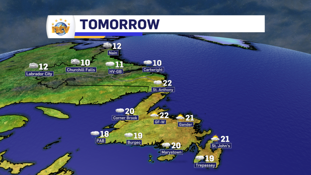
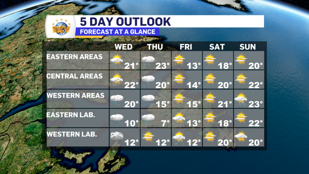
Expect mostly sunny skies and highs in the lower to middle teens across the region today. The exception will be on the Avalon Peninsula, the whole thing, where clouds are going to hang tough until 2 or 3 PM. After that point, we will join the sunny confederation of the Province.

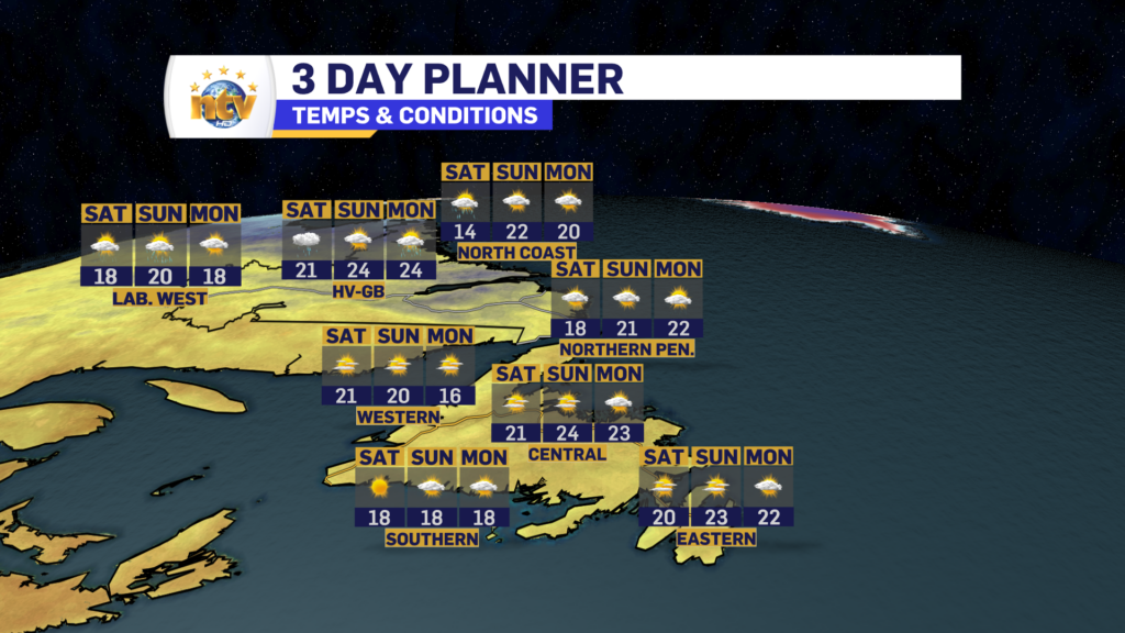
The Labour Day Long Weekend is looking great across the Province. Expect highs in the teens and 20s and lows in the teens. There will be some scattered showers in parts of Labrador, but that’s about it. So far as long weekend forecasts go, this is as easy as it gets.

A Fall-like Friday will give way to summer-like long weekend

After a rainy and windy Thursday for much of the Province, a fall-like airmass will take hold overnight and close out the work week. A cold front will sweep east of the Avalon during the overnight, shoving the tropical airmass, and the associated moisture from Hurricane Franklin, offshore.

There’s not much to say about the next 3 to 4 days as an area of high pressure builds in. We can expect a cool Friday, followed by a warmer Saturday, Sunday, and Monday across the Province. Sunshine will be plentiful and showers will pop up in the afternoons over western parts of the Big Land. Otherwise, it is about as quiet as forecast as it gets this time of year, after what was a very busy week.

Eddie’s Afternoon Update; Rain continues on the Avalon

The rain will continue to fall on the Avalon Peninsula and southeast Labrador through the afternoon before finally ending this evening or into the overnight. I break it down in this afternoon’s video update.

Heavy rain arrives this evening and continues through Thursday

An area of low pressure working through the Gulf of St. Lawrence this evening is pushing rain across the Island and a large part of southeastern Labrador. The rain will continue to work in as the night progresses and will become heavy at times for many areas as that happens. Rainfall Warnings are in effect for much of southern Newfoundland and parts of southeastern Labrador.

The rain will continue through tonight and much of Thursday in southeast Labrador. On the Island, the rain will end from west to east as the day goes on, however, showers and light will persist on the West Coast. Meanwhile, the Avalon and Burin Peninsulas will see extremely heavy rainfall rates Thursday morning, before that eases, and eventually ends, in the afternoon.

Rainfall amounts will be highest over southern parts of the Island and southeast Labrador, where a widespread 50-100 mm is in the forecast. Generally, amounts will be under 50 mm as one moves away from those locations.

This amount of rain will certainly lead to some localized flooding, but I’m not expecting to see widespread flooding and washouts unless the amounts are significantly higher than forecast. Which is certainly possible in some areas, given the setup.

The reason the rainfall rates are going to be high is because the area of low pressure moving through the Gulf is going to pick up some tropical moisture from Hurricane Franklin. And while Franklin is going to remain well to our south, its moisture will not.

The image below shows atmospheric moisture, and notice that fetch of brighter colours directed right into the Province. That’s the moisture feed from Franklin getting pulled into the area. This will slowly move east on Thursday, and be replaced by a crisp, fall-like airmass for Friday.

In addition to the rainfall, we are going to see some fairly high early-season wind gusts over parts of the West Coast and Southern Labrador tomorrow. Gusts in some areas will be near, or just higher than, 100 km/h for a period of hours on Thursday. The map below shows the highest expected wind speeds over the next 24 hours, and again, most of that will happen during the day tomorrow.

Note the two high spots, which are from near Cartwright to Battle Harbour in Labrador (on the coast) and north of Bonne Bay on the Island. These are the areas that may see gusts nearing 100 km/h on Thursday. Outside of that, expect the more standard gusts to 50 to 70 km/h later tonight and Thursday.

These winds are not to do with Franklin, but with the separate system bringing the rainfall.

Lows tonight dip to near 20 on the Island and highs tomorrow will sit near 20. In Labrador lows tonight will be in the 5 to 7 range, with highs near 11 tomorrow.

Wednesday morning update; Warnings expanded and rain is on the way

The Rainfall Warnings have been expanded by the Environment and Climate Change Canada Weather in Gander. The warning(s) now include the southern parts of the Island from the Avalon Peninsula Southeast to Bay St. George. Expect between 50 and 100 mm of rain in these areas by Thursday evening. Locally higher amounts are possible.

A Rainfall Warning was also issued for Eagle River and Cartwright to Black Tickle in southeastern Labrador. Up to 90 mm of rain will fall in this area by Thursday evening, with locally higher amounts possible.

The rain will overspread the region later today and will continue, heavy at times, for most areas through Thursday afternoon or evening. Future Radar does an excellent job of showing this.

Stay tuned for further updates throughout the day

Wednesday & Thursday looking rainy for much of the Province, in part due to Hurricane Franklin

Generally quiet conditions will be found across the Province overnight, ahead of our next weather maker. The exception will be Labrador West and North, where showers will be found as a cold front sinks south. That cold front will move through much of the Big Land come Wednesday morning, and temperatures will fall into the 6° to 10° range. On the Island, expect mostly clear skies and lows in the middle teens.

Wednesday will see rain arrive in Labrador throughout the day and onto the Island in the afternoon. Rainfall rates will be intense over southern sections of Newfoundland during the late afternoon and evening. Highs reach the upper teens to lower 20s on the Island and lower teens in Labrador.

Wednesday night and Thursday will see the rain continue across much of the Province as we get an influx of moisture from Hurricane Franklin.

While Franklin will not directly impact the area, the moisture from it will help to drive intense rainfall, at times, over the Island through Thursday. Rainfall Warnings and Special Weather Statements are in effect.

Rainfall amounts will be heaviest over southern Newfoundland and southeast Labrador, where 50-100 mm will fall. Amounts will be lesser as one moves farther north on the Island and away from the southeast corner of Labrador.

This moisture will clear out for Friday and will set the stage for a lovely weekend across much of the Province.

Tuesday’s Forecast; sunny and warm for most of N.L.

Good Tuesday morning!

The weather across the Province today is going to be on the sunny side for most of the Province. The exception will be Labrador West, where showers will move in this afternoon.

Temperatures today peak in the upper teens to lower 20s for most areas. However, in northern Labrador highs will be closer to the lower teens.

Have a great day!

Eddie

Eddie’s forecast; Tuesday looks large, Wednesday and Thursday… not so much

Tonight and Tomorrow

The weather across the Province is looking fairly quiet across the Province overnight and Tuesday. On a large scale, we can expect mostly clear skies tonight and generally sunny skies tomorrow (Tuesday). There will be some late-day showers that push into Labrador West.

Lows tonight will dip into the teens across the region

Tuesday will see highs into the teens and 20s. The warmest readings will be found in the southeast corner of Labrador!

The Extended

Heavy rainfall moves across the Island between Wednesday and Thursday. This rain will, initially, not be associated with Hurricane Franklin.

However, some moisture from the storm may get drawn into the system bringing rainfall as Franklin passes east of the Avalon alter this week, which will increase rainfall rates over the course of the 2 days.

At this point, the rainfall rates are hard to ascertain, but the Special Weather Statement issued by ECCC NL states 60-90 mm for a large part of the Island. I think those amounts will be attained and possibly exceeded over the course of the two days.

While the forecast is still a bit fuzzy, there are some things you can do to get prepped for the rain

  • Clear gutters and downspouts
  • Clear storm drains around your property
  • Ensure sump pumps are working

I’ll have your next update tomorrow!

Environment Canada issues Special Weather Statement for heavy rainfall Wednesday into Thursday

A Special Weather Statement has been issued by the ECCC NL Weather Office in Gander for the following areas:

  • Avalon Peninsula Southeast
  • Avalon Peninsula Southwest
  • Burin Peninsula
  • Connaigre
  • Burge – Ramea
  • Channel-Port aux Basques and vicinity
  • Corner Brook and vicinity
  • Deer Lake – Humber Valley
  • Gros Morne
  • Bay St. George
  • Green Bay – White Bay
  • Northern Penisula East
  • Parson’s Pond – Hawke’s Bay
  • Port Sauders and the Straits

Current details: Rain at times heavy is expected.

Total rainfall: 60 to 90 mm, with higher amounts possible.

Locations: the south and west coasts of Newfoundland, the Great Northern Peninsula, Deer Lake – Humber Valley, and Green Bay – White Bay.

Time span: Wednesday morning until Thursday evening.

Similar storms in the past have caused road shoulder erosion and washouts as well as elevated river levels.

Remarks: There remains some uncertainty with regard to how this disturbance, which is unrelated to Hurricane Franklin, will interact with the hurricane. As this information becomes clearer, the timing and locations of the heaviest rain as well as expected rainfall amounts may change.

Be sure storm drains and gutters are cleared of debris. Heavy downpours can cause flash flooding and pooling of water. Localized flooding in low-lying areas is possible.

Eddie’s update; Showers start our Monday, and Sunshine finishes it.

Areas of showers across a good bit of the Province have started our Monday off on a bit of a soggy note. The showers will generally move offshore over the next few hours and the clouds will follow suit. It may be hard to imagine now, but by early afternoon, much of N.L. will be in the sunshine. Highs today will be in the teens to near 20º.

The map below shows us how the day will play out, on a Provincial scale.

Scroll to top