weather alert

Tuesday’s forecast; the sunshine returns!

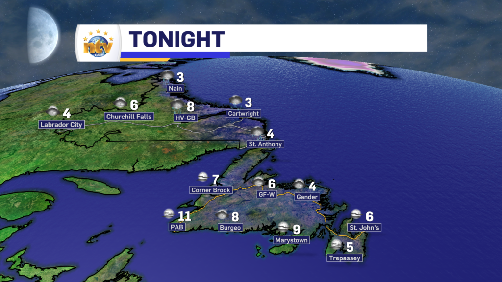
Our Tuesday morning is certainly starting on the chilly side of things, with readings into the single digits above and below freezing on the Island, and generally below in Labrador. Eastern and northeast areas of the Island generally see cloudy skies to start the day, and in many areas, it’s probably damp. Meanwhile, areas to the west, south, and northeast and into Labrador are generally dry.

Today, we will see a fair bit of sunshine on the Island. Areas that start cloudy, like in the east, will see increasing sunshine throughout the day. Highs reach the middle to upper single digits on the Island and across the Big Land. Labrador will also see partly to mostly cloudy skies today, with some showers or flurries pushing into the west this afternoon and evening.

After today, temperatures will generally be on the upswing for the remainder of the week. Highs on the Island will creep back into the teens and Labrador will work back into the upper single digits to lower teens. The next chance of rain will be from late Wednesday through early Thursday on the Island. Beyond that the next chance of rain on the Island will be Saturday, while Labrador will see a chance of rain and snow.

I’ll have your next forecast later today.

Have a great one!

Eddie

Rainfall Warning(s) in effect for various areas of Newfoundland this weekend

A Rainfall Warning remains in effect for much of central, western and northern Newfoundland for Sunday

Special Weather Statement issued for Monday; Significant storm expected

THESE ALERTS HAVE BEEN ENDED

The Environment and Climate Change Canada Weather Office in Gander has issued a SPECIAL WEATHER STATEMENT for Monday for the following locations:

  • The Avalon Peninsula North
  • The Avalon Peninsula Southeast
  • St. John’s & vicinity
  • The Avalon Peninsula Southwest
  • The Burin Peninsula
  • Bonavista North
  • The Bonavista Peninsula
  • Clarenville & vicinity
  • Terra Nova

Significant rainfall and strong winds are expected Monday.

Locations: eastern Newfoundland.

Total rainfall: 30 to 50 mm with locally higher amounts possible.

Maximum wind gusts: 60 to 80 km/h from the northeast.

Time span: Monday morning to Tuesday morning. Remarks: rainfall rates may reach 5 to 10 mm per hour over some areas. Similar storms in the past have caused minor flooding and power outages.

Rainfall Warnings issued for parts of the South Coast and Burin Peninsula

The Environment and Climate Change Canada Weather office in Gander has issued a RAINFALL WARNING from Friday night through Saturday for the following areas:

  • Connaigre
  • The Burin Peninsula

Current details: Rain, at times heavy, is expected.

Total rainfall: 50 to 70 mm, locally higher amounts possible.

Locations: Burin and Connaigre Peninsulas.

Time span: Friday night and Saturday.

Remarks: Rainfall rates of 5 to 10 mm per hour are possible in the heaviest downpours.

Heavy downpours can cause flash floods and water pooling on roads. Localized flooding in low-lying areas is possible.

Rainfall warnings are issued when significant rainfall is expected.

Wildfire smoke from NWT fires prompts Air Quality Alert from Environment Canada

Smoke from distant forest fires may cause a reduction in air quality.

Current details: Smoke is causing or expected to cause poor air quality and reduced visibility.

Locations: most of Newfoundland and Labrador

Time span: through Thursday or longer.

Remarks for Newfoundland: Smoke plumes from distant forest fires can be expected over Newfoundland at various times over the next couple of days or more. The smoke will be more persistent in some areas than others, especially central, western and northern Newfoundland as suggested by latest dispersion models. Some of the smoke will remain aloft while some will descend closer to ground level causing reduced air quality at times. Associated haze will likely give the sun a reddish appearance.

Remarks for Labrador: Smoke plumes from distant forest fires can be expected over Labrador at various times over the next couple of days or more. The smoke will be more persistent in some areas than others as suggested by latest dispersion models. Some of the smoke will remain aloft while some will descend closer to ground level causing reduced air quality at times. Associated haze will likely give the sun a reddish appearance.

Wildfire smoke can be harmful to everyone’s health even at low concentrations. Everyone can take action to reduce their exposure to wildfire smoke.

People with lung disease (such as asthma) or heart disease, older adults, children, pregnant people, and people who work outdoors are at higher risk of experiencing health effects caused by wildfire smoke. Speak with your health care provider about developing a management plan for wildfire smoke events and maintaining a supply of necessary medications at home and always carrying these medications with you during wildfire season.

Stop or reduce your activity level if breathing becomes uncomfortable or you or someone in your care feel unwell. Contact your healthcare provider or local health authority if you develop severe symptoms or need advice.

Check the Air Quality Health Index (AQHI) and monitor your symptoms. People respond differently to smoke. Mild irritation and discomfort are common and usually disappear when the smoke clears. Drinking lots of water can help your body cope with the smoke.

If you have an HVAC system in your home, use the highest-rated MERV filter for your system (ideally rated 13 or higher) and set the fan to recirculate air constantly. You can also use a portable High Efficiency Particulate Air (HEPA) air cleaner. Keep your doors and windows closed if the temperature in your home is comfortable.

Take a break from the smoke at a location in your community where you can find clean, cool air.

If you must spend time outdoors, a well-fitted respirator-type mask (such as a NIOSH-certified N95 or equivalent respirator) that does not allow air to pass through small openings between the mask and face, can help reduce your exposure to the fine particles in smoke. These fine particles generally pose the greatest risk to health. However, respirators do not reduce exposure to the gases in wildfire smoke. It is important to listen to your body and reduce or stop activities if you are experiencing symptoms.

Be sure to check on people in your care and those around you who may be more susceptible to smoke.

Reduce sources of indoor air pollution. If you can, avoid smoking or vaping indoors, burning incense and candles, frying foods, using wood stoves, and vacuuming. Dust on indoor surfaces can be removed by wiping and wet mopping during a pollution episode.

If you experience any feelings of stress, anxiety, or depression, contact your mental health care provider for advice or visit https://www.wellnesstogether.ca/en-CA.

Visit http://www.airhealth.ca for information on how to reduce your health risk and your personal contribution to pollution levels, as well as for current and forecast AQHI values.

Saturday starts nice, but rain and showers arrive later today and this evening

Saturday’s Outlook

The day will start off sunny for much of the Island, but showers will pop over the West Coast early in the day, and then over central and eastern areas in the afternoon. Highs will be warmer, into the middle and upper teens. It will also be a bit breezy, with westerlies as high as 60 km/h.

Rain will move into eastern and southeastern areas Saturday evening and will linger into very early Sunday morning.

Futuirecast times out the showers quite well, as you can see in the video below.

Labrador will have a few showers here and there throughout the day, with highs of 8 to 14.


Sunday’s Outlook

A few showers over central and western Newfoundland, and in Labrfaodr West. Otherwise it is partly to mostly cloudy with highs in the upper single digits in Labrador to middle teens on the Island.

The Long Range

Quiet weather takes hold for next week as an area of high pressure builds in. Highs will be in the teens and lows in the single digits, pretty well across the board.

After a chilly Friday night, Saturday will see a nice turnaround… for some!

Tonight’s Outlook

The weather across the Island looks fairly calm overnight, except on the GNP where showers will be on the go. Otherwise, we can expect lows of 6 to 10 for most. That being said, some areas will get colder, especially eastern and central, and FROST ADVISORY is in effect for tonight for those areas. Skies are partly cloudy to mostly clear.

Labrador will see showers on the coast, while inland areas are partly cloudy. Lows of 3 to 8, which will be warmer than last night for most!

Saturday’s Outlook

The day will start off sunny for much of the Island, but showers will pop over the West Coast early in the day, and then over central and eastern areas in the afternoon. Highs will be warmer, into the middle and upper teens. It will also be a bit breezy, with westerlies as high as 60 km/h.

Rain will move into eastern and southeastern areas Saturday evening and will linger into very early Sunday morning.

Labrador will have a few showers here and there throughout the day, with of 8 to 14.


Sunday’s Outlook

A few showers over central and western Newfoundland, and in Labrfaodr West. Othewise it is partly to mostly cloudy with highs in the upper single digits in Labrador to middle teens on the Island.

The Long Range

Quiet weather takes hold for next week as an area of high pressure builds in. Highs will be in the teens and lows in the single digits, pretty well across the board.

Environment Canada issues Frost Advisory for Friday night for Eastern, Central Newfoundland

THIS ALERT HAS BEEN ENDED AS OF SEPTEMBER 23, 2023

The ECCC NL Weather Office in Gander has issued a Weather Alert. A Frost Advisory is in effect from late Friday night to early Saturday morning. The areas under the advisory are as follows:

  • The Avalon Peninsula North
  • The Avalon Peninsula Southeast
  • St. John’s & vicinity
  • The Avalon Peninsula Southwest
  • Grand Falls-Windsor and vicinity
  • Bay of Exploits
  • Bonavista North
  • Clarenville and vicinity
  • Gander and vicinity
  • Green Bay – White Bay
  • Terra Nova

Current details: Frost may damage some crops in frost-prone areas.

Minimum temperatures: +2 to +9 in northeastern Newfoundland, -1 to +5 elsewhere (coolest in low-lying areas).

Locations: Avalon peninsula, eastern and northeastern Newfoundland

Time span: early Saturday morning.

Remarks: Patchy frost is expected to form as clear skies and light winds coincide with cool temperatures, especially in low-lying areas.

Cover up plants, especially those in frost-prone areas.

Frost advisories are issued when temperatures are expected to reach the freezing mark during the growing season, leading to potential damage and destruction to plants and crops.

Scroll to top