Weather Alerts

Rainfall Warning, Wind Warning and Special Weather Statements in effect for the weekend

AS OF 6:55 AM ON OCTOBER 21, 2023, THESE ALERTS HAVE BEEN ENDED OR MODIFIED. PLEASE VISIT THE HOME PAGE FOR THE LATEST WEATHER ALERTS.

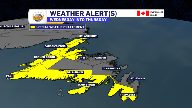
A strong area of low pressure will move through the region this weekend. This promises to bring a healthy dose of rain and wind to the Island starting Saturday and lasting into Sunday. The Environment and Climate Change Canada Weather Office in Gander has issued three weather alerts, so far, ahead of this system. They are as follows…


A Special Weather Statement is in effect from Saturday through Sunday for the following areas:

  • The Avalon Peninsula Southwest
  • The Avalon Peninsula Southeast
  • The Avalon Peninsula North
  • St. John’s & vicinity
  • The Burin Peninsula
  • Connaigre
  • Corner Brook & vicinity
  • Deer Lake – Humber Valley
  • Gros Morne
  • Bay St. George
  • Buchans and the interior
  • Grand Falls-Windsor & vicinity
  • Bay of Exploits
  • Green Bay – White Bay (Baie Verte Peninsula)
  • Northern Peninsula East
  • Parson’s Pond – Hawke’s Bay
  • Port Saunders and the Straits (Northern Peninsula West)

Current details: Significant rainfall expected this weekend.

Locations: southern, western, central, northern, and parts of northeastern Newfoundland.

Total rainfall: widespread 40 to 90 mm with locally 100 mm or more possible over parts of southern, central and western Newfoundland, while eastern areas will see as much 50 mm of rain. Locally higher amounts are likely.

Wind Speeds: Wind speeds will peak from the southeast as high as 80 km/h, with gusts to 100 km/h possible over exposed areas.

Remarks: Rain is forecast throughout the weekend but latest forecast guidance suggests the heaviest rainfall will come in two waves with the first being Saturday afternoon into Saturday evening and the second late Saturday night through most of Sunday.

Similar storms in the past have caused hazardous driving conditions, pooling of water on roadways, and localized flooding in low-lying areas.

Be sure storm drains and gutters are cleared of debris.


A RAINFALL WARNING is in effect for the following area from Saturday morning thru Sunday morning:

  • Burgeo – Ramea
  • Channel-Port aux Basques

Current details: Rain, at times heavy, is expected.

Total rainfall: 50 to 90 mm, with locally heavier amounts possible.

Locations: southwestern Newfoundland.

Time span: Saturday morning to Sunday morning.

Remarks: Rainfall rates of 5 to 10 mm per hour are possible in the heaviest downpours.

Heavy downpours can cause flash floods and water pooling on roads. Localized flooding in low-lying areas is possible.

Rainfall warnings are issued when significant rainfall is expected.


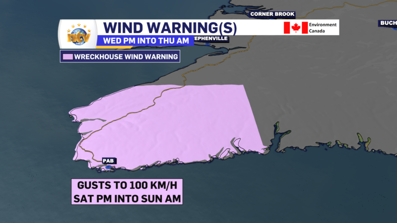
A Wreckhouse Wind Warning is in effect for Saturday afternoon for the following areas:

  • Channel – Port aux Basques

Current details: Strong winds are expected or occurring.

Time span: Saturday afternoon.

Maximum gusts: southeasterly up to 120 km/h in the Wreckhouse area.

Be prepared to adjust your driving with changing road conditions due to high winds.

Wreckhouse wind warnings are issued when there is a significant risk of damaging winds.


FOR YOUR LATEST FORECAST, BE SURE TO VISIT THE THE WEATHER CENTRE BY CLICKING HERE

A Frost Advisory is in effect Tuesday night for much of central, western, and southern Newfoundland

THIS WEATHER ALERT HAS BEEN ENDED

A Frost Advisory has been issued for Tuesday night into early Wednesday morning by the Environment and Climate Change Canada Weather Office in Gander. The Frost Advisory is in effect for the following areas:

  • Burin Peninsula
  • Connaigre
  • Burgeo – Ramea
  • Channel-Port aux Basques and vicinity
  • Corner Brook & vicinity
  • Deer Lake – Humber Valley
  • Gros Morne
  • Bay St. George
  • Buchans and the interior
  • Green Bay – White Bay
  • Parson’s Pond – Hawke’s Bay

Current details: Frost may damage some crops in frost-prone areas.

Minimum temperatures: -2 to +2 in low-lying areas.

Locations: western, central and southern Newfoundland

Time span: tonight into early Wednesday morning

Remarks: Patchy frost is expected to form as clear skies and light winds coincide with cool temperatures, especially in low-lying areas.

Cover up plants, especially those in frost-prone areas.

Frost advisories are issued when temperatures are expected to reach the freezing mark during the growing season, leading to potential damage and destruction to plants and crops.

Environment Canada issues Wreckhouse Wind Warning for the weekend

The ECCC NL Weather Office in Gander has issued a Wreckhouse Wind Warning from Saturday afternoon through Sunday morning for the following area:

  • Channel-Port aux Basques

The text from the alert reads as follows:

Current details: Strong winds are expected or occurring.

Time span: Saturday afternoon until Sunday morning.

Maximum gusts: southeasterly up to 100 km/h in the Wreckhouse area.

Be prepared to adjust your driving to changing road conditions due to high winds.

Wreckhouse wind warnings are issued when there is a significant risk of damaging winds.

Environment Canada issues Special Weather Statement for heavy rainfall Wednesday into Thursday

A Special Weather Statement has been issued by the ECCC NL Weather Office in Gander for the following areas:

  • Avalon Peninsula Southeast
  • Avalon Peninsula Southwest
  • Burin Peninsula
  • Connaigre
  • Burge – Ramea
  • Channel-Port aux Basques and vicinity
  • Corner Brook and vicinity
  • Deer Lake – Humber Valley
  • Gros Morne
  • Bay St. George
  • Green Bay – White Bay
  • Northern Penisula East
  • Parson’s Pond – Hawke’s Bay
  • Port Sauders and the Straits

Current details: Rain at times heavy is expected.

Total rainfall: 60 to 90 mm, with higher amounts possible.

Locations: the south and west coasts of Newfoundland, the Great Northern Peninsula, Deer Lake – Humber Valley, and Green Bay – White Bay.

Time span: Wednesday morning until Thursday evening.

Similar storms in the past have caused road shoulder erosion and washouts as well as elevated river levels.

Remarks: There remains some uncertainty with regard to how this disturbance, which is unrelated to Hurricane Franklin, will interact with the hurricane. As this information becomes clearer, the timing and locations of the heaviest rain as well as expected rainfall amounts may change.

Be sure storm drains and gutters are cleared of debris. Heavy downpours can cause flash flooding and pooling of water. Localized flooding in low-lying areas is possible.

Scroll to top