weather forecast

Eddie’s Saturday update: Weather improves through the day

Very few storms came through overnight… disappointedly for some. Like me.

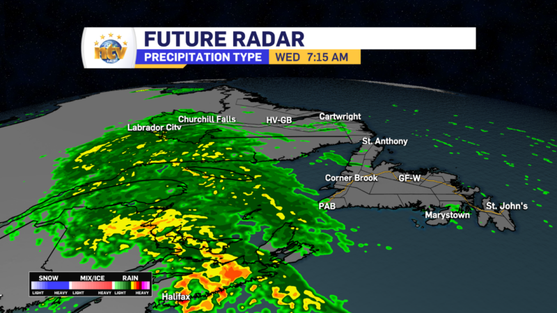
The radar shows we had rounds of heavy rain work across the Island over the last 12+ hours. However, the thunderstorms I thought would be found in the rain never transpired. Or if they did, they were much less widespread than it looked like they would be just yesterday.

18-hour satellite radar loop – August 11 to 12, 2023

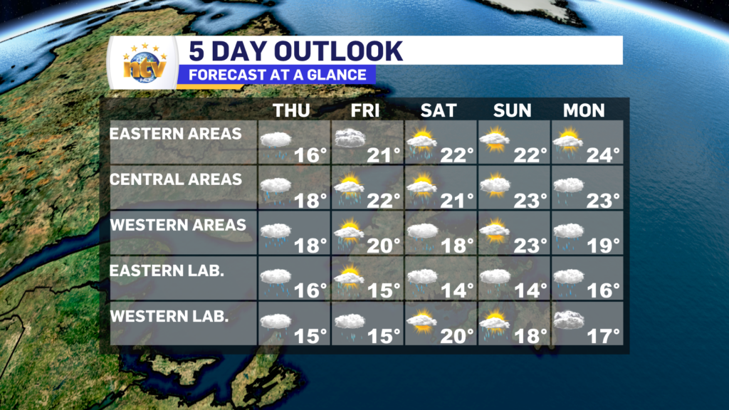
For the rest of today, the weather will generally improve on the Island, with sun and cloud becoming prevalent for most. The exception will be the West Coast and GNP, where showers and clouds will hang around through much of the day. Scattered showers will also be found this afternoon over central and eastern areas, with the chance of some isolated thunderstorms. Highs reach the upper teens to lower 20s.

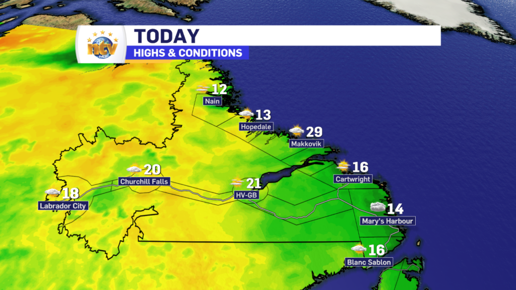
Southeast Labrador will see rain become widespread today and that will ease off tonight. Otherwise expect partly to mostly cloudy skies across the Big Land, with highs in the mid to upper teens.

Saturday’s forecast – August 12, 2023

Sunday will be a decent day across the Province, with highs in the upper teens and lower 20s for most.

Forecast for Sunday, August 12, 2023

Have a great Saturday!

Friday will be decent for most of N.L., before rain arrives this evening

Good Friday morning! We’ve made it to the end of another work week and it looks like Mother Nature is going to reward many of us with a decent day.

Expect a large part of the Province to see a mix of sun and cloud today, with highs reaching the middle teens to lower 20s this afternoon. The coolest readings will be found in northern Labrador and the warmest over parts of Central and eastern Newfoundland. Below is a map of the expected highs today

Friday’s forecast | August 11. 2023

There will be some exceptions to the sunshine, and those areas will be found over the West Coast, Great Northern Peninsula, and parts of southeast Labrador, where showers will linger throughout much of the day. I also cannot rule out the chance of passing showers over Central and Eastern areas, especially this morning. In fact, radar shows a few over the Avalon and another near Fogo Island. Track them yourself using the interactive radar on the NTV Weather Page!

The next area of low pressure will swirl in tonight, and this will bring some heavy rain to parts of the Island late tonight and early Saturday morning. The weather on the Island will improve Saturday, while parts of Labrador will see the rain linger into Saturday. There is even the risk of some thunderstorms over parts of Central and eastern Newfoundland late tonight and Saturday morning. The map below shows this threat, and all you need to know about is the brighter the color the more likely storms are to pop up.

RDPS CAPE (Convective Available Potential Energy) Index – August 12 at 9:30 AM NDT

The rain from this next low will hold off until later this evening or later. I’ll have a more detailed update on the timing of it all later today.

Also, Saturday evening looks like it may be your best chance to see the Perseids Meteor Shower. Here is a blog post I put up yesterday about the event!

Have a great day!

Eddie

A soggy Thursday is on tap for much of the Province

A slow-moving, sloth-like, area of low pressure is really making its presence known across parts of the Province this morning. Virtually all of Newfoundland and parts of western Labrador are waking up to either rain, showers, or drizzle. It’s also a bit windy, which makes being outside in any of this more unpleasant than it has to be. The radar loop from the last 6 hours, ending just before 7 AM this morning, shows us where the rain is. The brighter the color, the heavier the rain.

The area of low pressure will trudge across the Island today and the rain, showers and drizzle will continue across the Island because of it. The rain will generally become less widespread and more showery as the afternoon and evening progress. Except on the Baie Verte and Northern Peninsulas, where some heavier rain will arrive this evening. Also, southern Labrador will see the rain and showers increase later today as well, as the area of low pressure begins to make its way off the Island.

Along with the rain, we can see temperatures will also be on the cooler side today, with highs across the board in the teens. Today will certainly have a fall-like feel to it, even though we’re in the early stages of August.

There are some signs of warmer weather on the horizon, but we will have to wait until the weekend to see that. Speaking of the weekend, the next area of low pressure will swirl in Friday evening, and this will bring more rain, and wind, to the Province. Ferry crossings between NS and NL may be impacted, yet again.

I’ll have your next update later today.

Have a good one!

Eddie

Rain moves in tonight and continues through Thursday on the Island while showers linger in Labrador

The Overview

An area of low pressure will meander through the Gulf of St. Lawernece over the next 24 hours, before finally crossing over the Island late Thursday into early Friday. The presence of this low is driving rain across much of the region this afternoon, and the rain will only increase in coverage overnight and Thursday.

The rain will become moderate to heavy at times over much of the Island tonight, and that will linger through the day on Thursday. There is a slight risk of some embedded thunderstorms, but I don’t anticipate them to be widespread at this time. The rain will taper to showers Thursday afternoon from south to north. The showers will not fully end until early Friday morning.

The showers will increase in southern Labrador late tonight and that will turn into heavier rain Thursday afternoon. The rain in southern areas of the BIig Land will linger into late Friday.

Rainfall amounts by early Friday morning will be in the 15-30 mm range for a large part of the Island, with lower amounts in Labrador. The rainfall projection below highlights that well.

Lows tonight will generally be in the lower to mid-teens on the Island and lower teens to near 10° in Labrador. Thursday will see temperatures similar to the last couple of days, with highs in the mid-teens to near 20 across N.L. There will not be a lot of sunshine during the next 24 hours.

Wind speeds in the Wreckhouse area will continue to be a problem through early Thursday. A Wreckhouse Wind Warning remains in effect until that point, and gusts will be from the southeast as high as 110 km/h.

The Extended

Friday will start on the calm side but will feature scattered showers across much of the Island and parts of Labrador. Skies will be partly to mostly cloudy across the Province. Highs will be mid-teens through the Big Land to lower 20s over much of the Island.

Another area of low pressure will roll through Friday night into Saturday. This looks to bring another bout of heavy rain to the West Coast, and parts of southern Labrador in that time frame. Areas north and east of the low, look to largely miss out on the heaviest rain. This next low may impact ferry crossings to Nova Scotia during that time frame.

Sunday will see a nice recovery across much of the region, with sun and cloud and highs back to the 20s for much of the Island and near 20 for parts of Labrador.

FOR YOUR LATEST WEATHER, BE SURE TO CHECK OUT THE WEATHER PAGE

Wednesday morning update; Rain moves in this afternoon, while wind speeds pick up in the Wreckhouse area

Our next area of low pressure slowly swirls in from the southwest today, and this will help push clouds, showers, rain, and even some wind into the region as the day progresses. Morning radar shows showers and areas of rain are already approaching the southwest coast, which is a few hours ahead of schedule.

The rain will continue to spread across the region today, including in Labrador West. The timing of this is depicted quite well in the Future Radar product in the video below. This should help give you an idea of when the rain will arrive in your area.

There is also a Wreckhouse Wind Warning, which goes into effect this afternoon and will expire Thursday morning. Wind speeds in that time, in the area, will gust as high as 110 km/h. Make sure any loose items are secured and drivers going through the area, be sure to heed the signs!

Ferry crossings are going to be impacted today and tomorrow, and the morning crossings from Marine Atlantic have already been canceled due to high wind and waves. Be sure to check with them if you have plans in the next few days. Friday into Saturday may have some impacts as well.

Temperatures today peak in the mid to upper teens for much of the Province. I’ll have a further update for you this afternoon.

Have a great day!

Eddie

Tuesday update; clouds now, sunshine later!

Tuesday morning has started off on the cloudy, and even drizzly side, for many areas of the Province. The webcam images below from across Newfoundland and Labrador illustrate the point rather well.

As we move throughout the morning and into the afternoon, the general trend in the cloud cover should be a decreasing one. In fact, over the next several hours skies should turn partly cloudy to even mostly sunny across the bulk of the Province. That will happen first in western Labrador and southern Newfoundland and a bit later everywhere else. The loop of future cloud cover shows this rather well.

Temperatures this afternoon will be very similar to yesterday, where much of the Province peaks in the mid-teens to lower 20s. The warmest readings will be found in southwestern Newfoundland and interior and western parts of Labrador. While the coolest readings will be found along the coast of Labrador and near and along the north-facing shores of the Island.

Forecast for August 8, 2023

Beyond today, we see an area of low pressure arrive between Wednesday and Thursday. Initially, this will spread rain into Labrador West tomorrow, along with southern areas of the Island. But more of the rain moves in Wednesday night and sticks around through Thursday.

And you can bet with the increased rain chances, will come more cloud cover and not a big change in our temperatures. There are signs of a return to the warmth, but it is looking like that will take a few days. As of now it looks like later this week or by the weekend the 20s are back in play.

Have a great day and I’ll have your next update this afternoon!

-Eddie

Monday evening update: Sunshine returns Tuesday for much of the Province

Tonight’s Overview

The showers will continue across parts of eastern and central Newfoundland into the overnight while becoming much less numerous on the West and South Coasts. Skies will clear out over the southwest corner of the Island, while most other areas remain in the onshore, northerly flow which tends to bring in an abundance of low cloud. Lows of 9 to 12. The gusty winds from Notre Dame Bay to the East Coast of the Avlaon will remain up overnight, before slowly subsiding during the day on Tuesday.

Labrador will see partly cloudy skies, with lows in the 8 to 12 range. Pretty boring… I know!

Tuesday’s Overview

Generally a quiet day across the Province, with a mix of sun and cloud. Some showers will crop up over interior Labrador and drift toward Churchill Falls. That’s about it for precipitation. Highs of 16 to 22 across the region.

Wednesday will see a dry start, but showers move into Labrador West in the afternoon, along with southwestern and western Newfoundland. Highs will again be into the mid-teens to lower 20s for highs. Thursday looks like a rainy day across the board, as an area of low pressure swings in. The rain will taper for most areas by Friday morning. The rain will be significant for some locations.

For the latest forecast be sure to visit the new and improved NTV Weather Centre.

Scroll to top