weather forecast

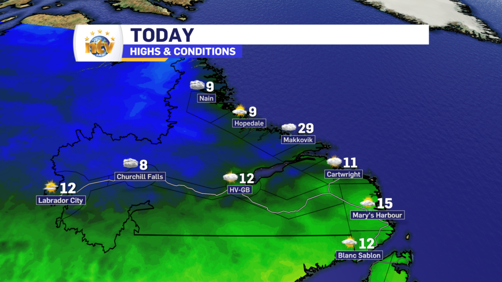
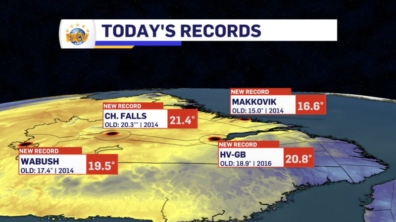
Record highs fell in Labrador Thursday as warmer air moved into the region

An unseasonably warm air mass moved into Labrador and allowed temperatures to soar into the teens and 20s across the Big Land. To put that into perspective, the average high today through much of Labrador is between 7° and 10°, so many areas were upward of 10° above normal! This air mass looks to stick around through the weekend, and I expect more record highs to be set in Labrador over the next few days. Some of the highest temperature anomalies, meaning how high temperatures will be above normal, will be over Labrador for the next 3 to 5 days. That’s what the big red, and almost white, area represents on the map below.

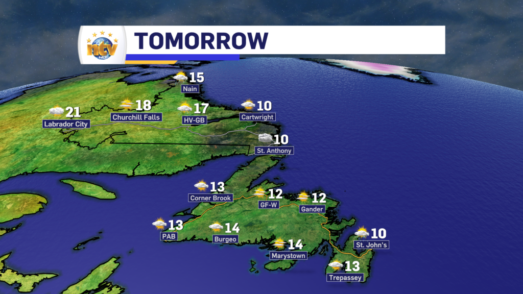
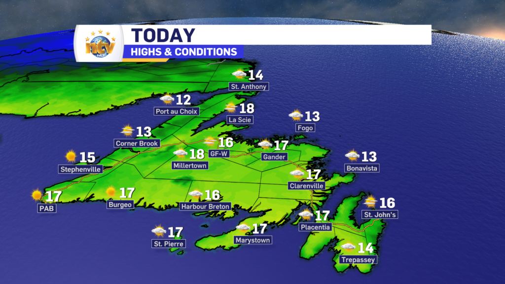
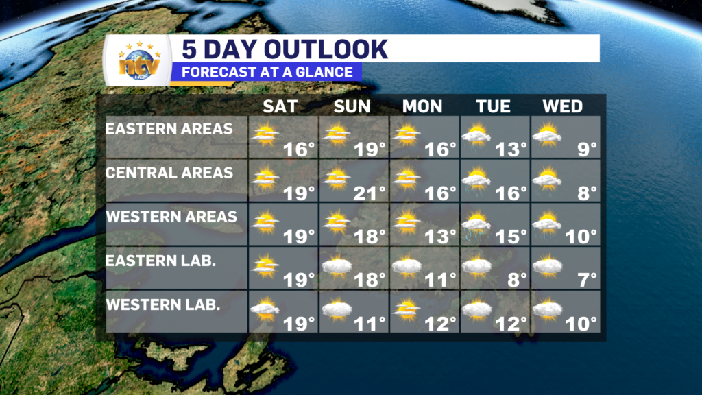
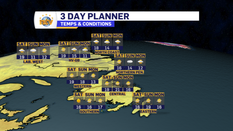
Weatherwise over the next few days things look fairly quiet across the Province. Other than scattered showers, we’re not really looking at a whole lot of weather on the go until later Sunday or Monday. At that point, the remnants from Tropical Storm Phillippe will bring some showers to the region. Temperatures remain in the teens to 20s through Tuesday, although hedge more teens, and not 20s. by the second half of the weekend and next week.

FOR YOUR FULL FORECAST, VISIT NTV.CA/WEATHER AND PLUG IN YOUR LOCATION!

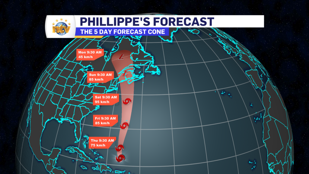
Speaking of Phillippe, the system is fairly disorganized and will head north over the next few days. At this time it looks to arrive in Nova Scotia late Saturday or early Sunday as a post or sub-tropical system and it will merge with a trough over the eastern parts of the US and Canada.

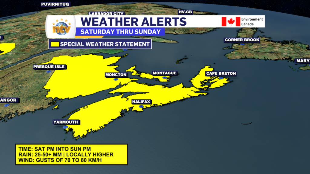
A Special Weather Statement has been issued by Environment Canada for NS, NB, and PEI for the Saturday afternoon through Sunday afternoon time frame. Some rain and wind are expected, but at this time this looks to resemble and strong fall storm and not a strong tropical system. Impacts should be less significant than what Lee brought a few weeks ago.

The warmup continues today across N.L.

Thursday will see a few early showers in eastern Labrador and on the Avalon, otherwise, it’s a mix of sun and cloud across most of the Province. Temperatures recover nicely after the chilly start for some locations on the Island and reach the mid-teens to lower 20s across the board. The warmest air will be found over the western parts of the Big Land.

Friday will see even warmer temps on the Island and Saturday will be similar. Widespread highs in the upper teens to lower 20s are likely and I suspect some records will be broken.

Sunday into Monday may see the remnants of Tropical Storm Phillippe working into the region. At this point, impacts to NL look to be mainly rain, while our Maritime neighbors will see more significant amounts of rain, wind, and high waves. This forecast will evolve and get clearer over the next couple of days.

The warmup starts tonight in Labrador, Thursday on the Island!

A warm front will push across Labrador overnight into early Thursday morning. This will send warmer air into the Big Land overnight, sending temperatures upwards in the West overnight. In fact, by Thursday morning it’ll be warmer than what is now for areas like Labrador City and Churchill Falls. Meanwhile, eastern Labrador and the Island will see a chilly night. With many areas on the island falling near, or below the freezing mark.

Thursday will see a few early showers in eastern Labrador and on the Avalon, otherwise, it’s a mix of sun and cloud across most of the Province. Temperatures recover nicely and reach the mid-teens to lower 20s. The warmest air will be found over the western parts of the Big Land.

Friday will see even warmer temps on the Island and Saturday will be similar. Widespread highs in the upper teens to lower 20s are likely and I suspect some records will be broken.

Sunday into Monday may see the remnants of Tropical Storm Phillippe working into the region. At this point, impacts to NL look to be mainly rain, while our Maritime neighbors will see more significant amounts of rain, wind, and high waves. This forecast will evolve and get clearer over the next couple of days.

Wednesday will feel very much like fall across the Province

Good Wednesday morning!

A cold front moved through the Province on Tuesday and behind it, we’ve got a very fall-like air mass working its way in. As of 6:30 AM NDT temperatures across the Province are generally in the lower to middle single digits. Northerly winds have taken over behind the front and an area of high pressure is located over western Labrador and eastern Quebec.

The weather across the Province today will generally be partly cloudy, a tad breezy and cool. Highs will only be in the mid-single digits to about 13º or 14º. While most areas will see the wind speeds coming down throughout the day, eastern areas may see it creep up a bit as the pressure gradient between an offshore low and the Quebec/Labrador high tightens a bit.

We will see a gradual return to warmer temperatures tomorrow and Friday. And then our attention will turn to Tropical Storm Philipe which looks like it may impact the weather across the Maritime Provinces later this weekend (Sunday). While it looks like impacts to NL will be limited, this still needs to be watched closely. Still a little early to get into impacts, but assuming the track is toward NS, the normal tropical influences will be felt; wind, rain, and high seas.

Showers return for Tuesday, ahead of a cold front

We are seeing some showers around this morning, particularly over interior, wester and northwestern Newfoundland along with parts of southern Labrador. The radars on the Island are doing a pretty good showing us where the showers are where they’re headed.

Generally the showers are moving from west to east this morning. Throughout the day they will primarily affect areas of wester, central and northwestern Newfoundland. However southern and eastern areas will see some scattered showers later today and this evening. Futurecast does a good job of playing that out.

Temperature wise today, we are looking at teens on most of the Island, except the GNP where single digits will be the rule. We are also looking at single digits in most of Labrador today as well. Expect a mix of sun and cloud in the Big Land and mostly cloudy skies on the Island.

Have a great day!

/Eddie

Monday looks nice, with just a few showers later in Labrador West

Good Monday morning!

Today will be another quiet day on the Island with abundant sunshine… eventually. There may be some clouds around this morning, but generally, we should see a decrease in whatever is out there by late morning. Highs will reach the middle teens, and wind speeds will generally be light to moderate from the west. It’ll be a bit higher on the Great Northern Peninsula.

Newfoundland’s forecast for today – October 2, 2023

Labrador will have a day where there is a bit more cloud cover, it’s a little more breezy and it will also be considerably cooler than the Island portion of the Province. Highs throughout the Big Land today will range in the 5º to 10º range, except in the southeast. In the southeast highs will reach the lower teens, before cooler air arrives later today.

Labrador’s forecast for today – October 2, 2023

There is a bit of a cool down on the way for the middle and later part of the week as a fall-like air mass moves across the region, however, it does look like we get a return to warmer temperatures by late week and next weekend.

I’m not going to be on the NTV this evening. I’ll be back tomorrow!

See you then!

October starts on a high note, weather-wise!

Sunday’s Forecast

Sunny again on the Island, with highs in the upper teens to near 20°. Labrador will see clouds on the increase throughout the day. Hazy skies will be over some areas, which is the smoke from the wildfires burning out west.

Extended Forecast

Monday starts off like the weekend ended, generally sunny and quiet across NL. Temperatures will be a bit cooler in Labrdoar West as some cooler air begins to work in from the northwest. Highs reach the mid to upper teens for most, except lower teens in Labrador West.

We see a bit more of an active weather pattern next week, with some showers rolling in Tuesday and Wednesday over the Island. And with that will come cooler highs, in the upper single digits to lower teens.

The weekend forecast is as easy as it gets!

Saturday’s Forecast

Mostly sunny Province-wide, with highs in the middle to upper teens. Some areas may get near 20°! Winds will be from the south or southwest at 15-25 km/h. There may be some hazy skies over some locations, due to the wildfire smoke that has advected to the region from western Canada.

Sunday’s Forecast

Sunny again on the Island, with highs in the upper teens to near 20°. Labrador will see clouds on the increase throughout the day. Hazy skies will be over some areas, which is the smoke from the wildfires burning out west.

Extended Forecast

Monday starts off like the weekend ended, generally sunny and quiet across NL. Temperatures will be a bit cooler in Labrdoar West as some cooler air begins to work in from the northwest. Highs reach the mid to upper teens for most, except lower teens in Labrador West.

We see a bit more of an active weather pattern next week, with some showers rolling in Tuesday and Wednesday over the Island. And with that will come cooler highs, in the upper single digits to lower teens.

The weekend forecast is as easy as it gets!

Friday Night’s Forecast

Generally clear across the Province. Expect lows of 5 to 10 on the Island, with patchy frost in Central. Labrador will see lows near 5°, except in Labrador West, where it will be nearer to 1°.

A Frost Advisory is in effect for Grand Falls-Windsor and vicinity

Saturday’s Forecast

Mostly sunny Province-wide, with highs in the middle to upper teens. Some areas may get near 20°! Winds will be from the south or southwest at 15-25 km/h. There may be some hazy skies over some locations, due to the wildfire smoke that has advected to the region from western Canada.

Sunday’s Forecast

Sunny again on the Island, with highs in the upper teens to near 20°. Labrador will see clouds on the increase throughout the day. Hazy skies will be over some areas, which is the smoke from the wildfires burning out west.

Extended Forecast

Monday starts off like the weekend ended, generally sunny and quiet across NL. Temperatures will be a bit cooler in Labrdoar West as some cooler air begins to work in from the northwest. Highs reach the mid to upper teens for most, except lower teens in Labrador West.

We see a bit more of an active weather pattern next week, with some showers rolling in Tuesday and Wednesday over the Island. And with that will come cooler highs, in the upper single digits to lower teens.

A beauty Friday is on tap for most of the Province!

Friday will see sunshine across much of the Province, with the exception being the coast of Labrador. I’m not expecting dense clouds and fog in the area, but some mostly cloudy to overcast skies are certainly a possibility. Highs will be in the middle teens to near 20°.

The reason for the quiet and calm weather we’ve been having is a ridge of high pressure. The pattern set up shop earlier this week and looks to remain in place for the next couple of days. This pattern will break down a bit next week, allowing for a slightly more active weather pattern to take hold. I’m going to enjoy it this weekend!

The weekend is looking quite nice, across the province as the area of high pressure continues to dominate the weather picture. The sunshine, mild days, and cool nights will continue. There will be some showers running through the Big Land Saturday night and Sunday and possibly over Western Newfoundland Sunday as well.

Scroll to top