weather forecast

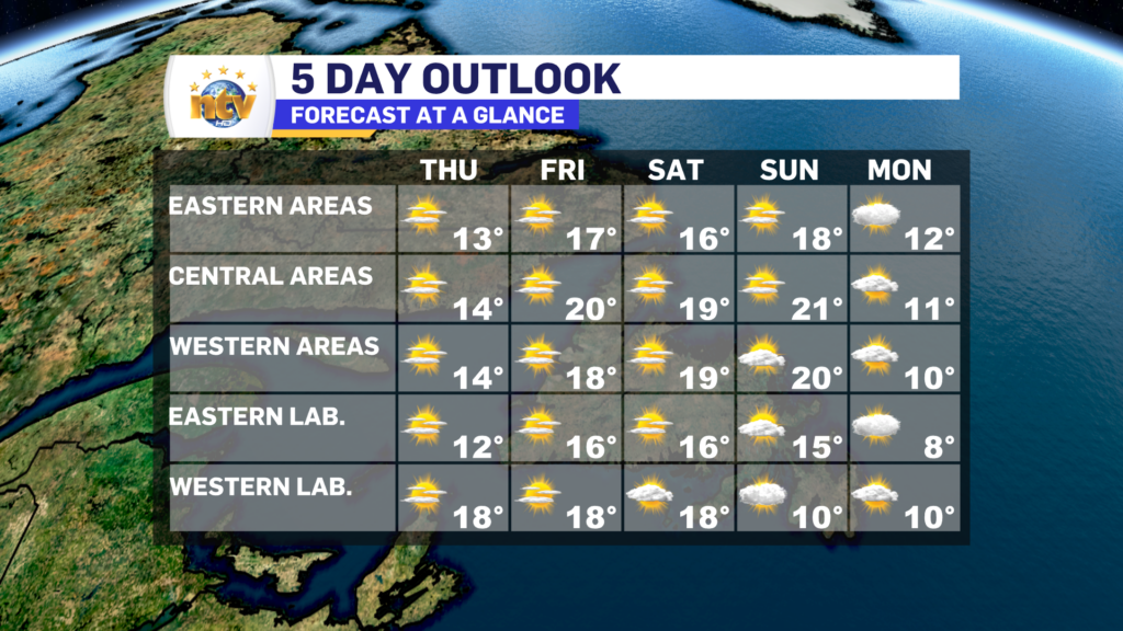
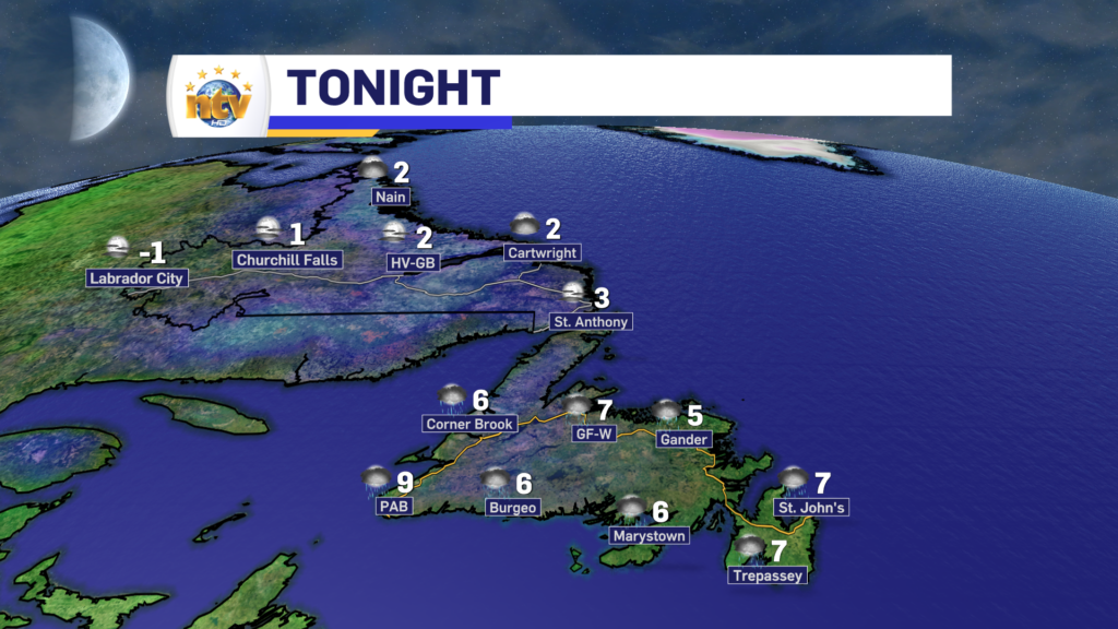
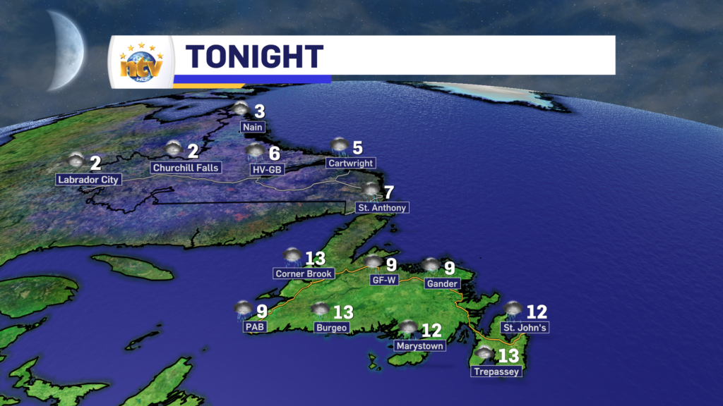
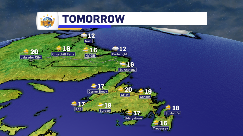
Friday looks gorgeous, but we have a chilly Thursday night to get through first!

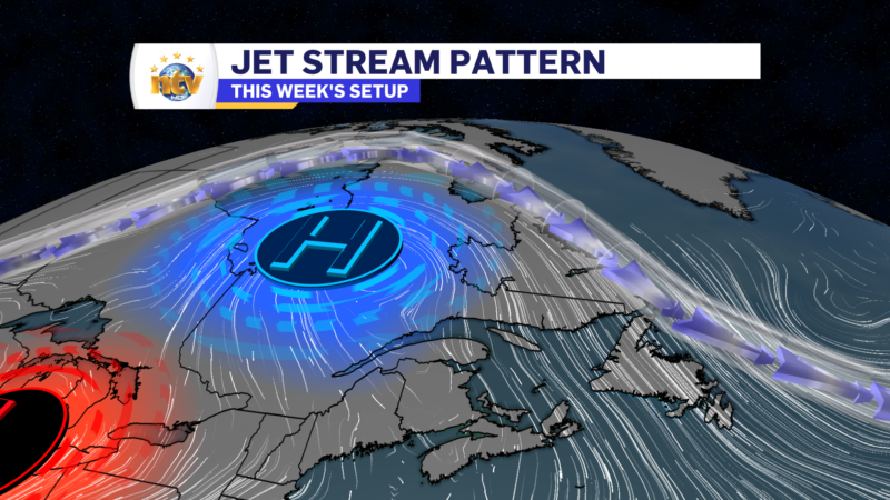
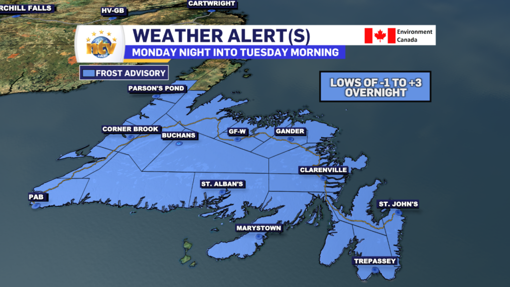
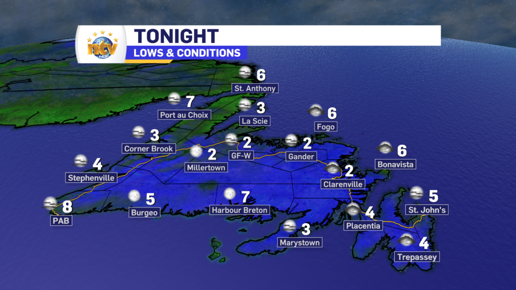
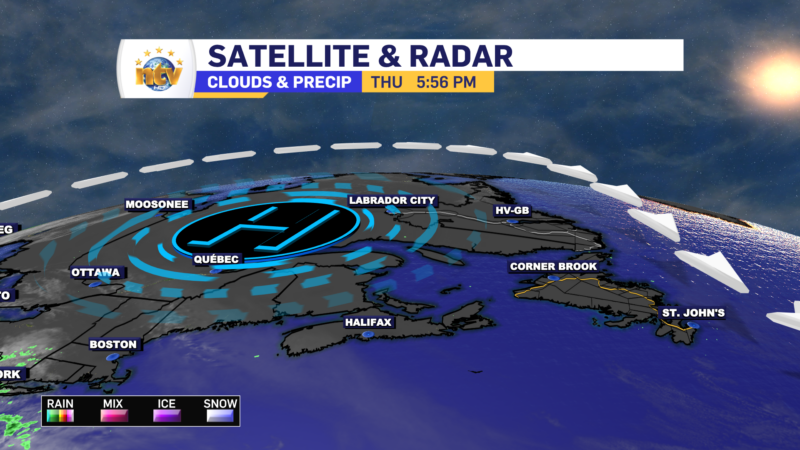
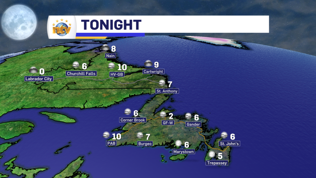
An area of high pressure is keeping the weather very quiet across Newfoundland and Labrador and will do so for the next few days. The high will keep the days sunny and mild and the nights chilly and clear. This is the perfect combination to get some frosty night, and we may see just that tonight. In fact, a Frost Advisory is in effect for much of Newfoundland for tonight!

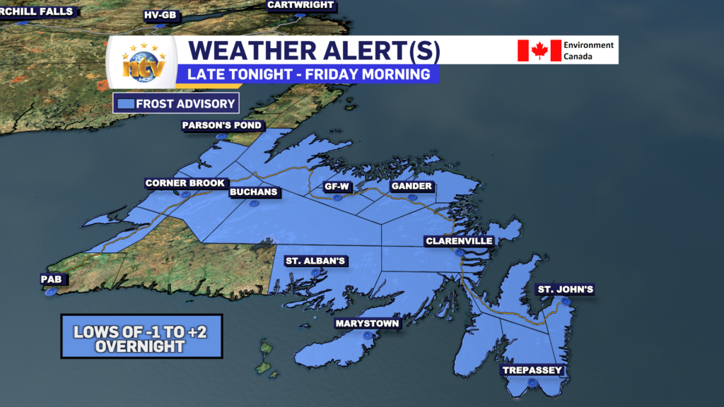
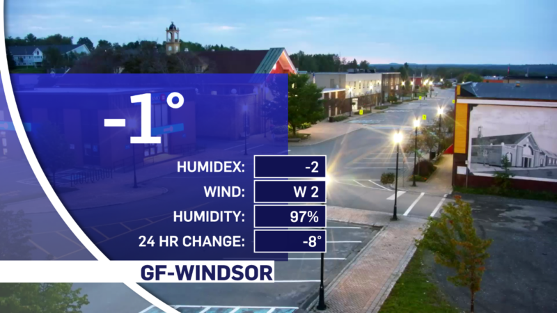
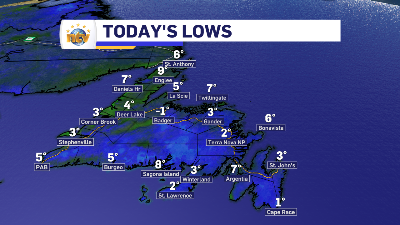
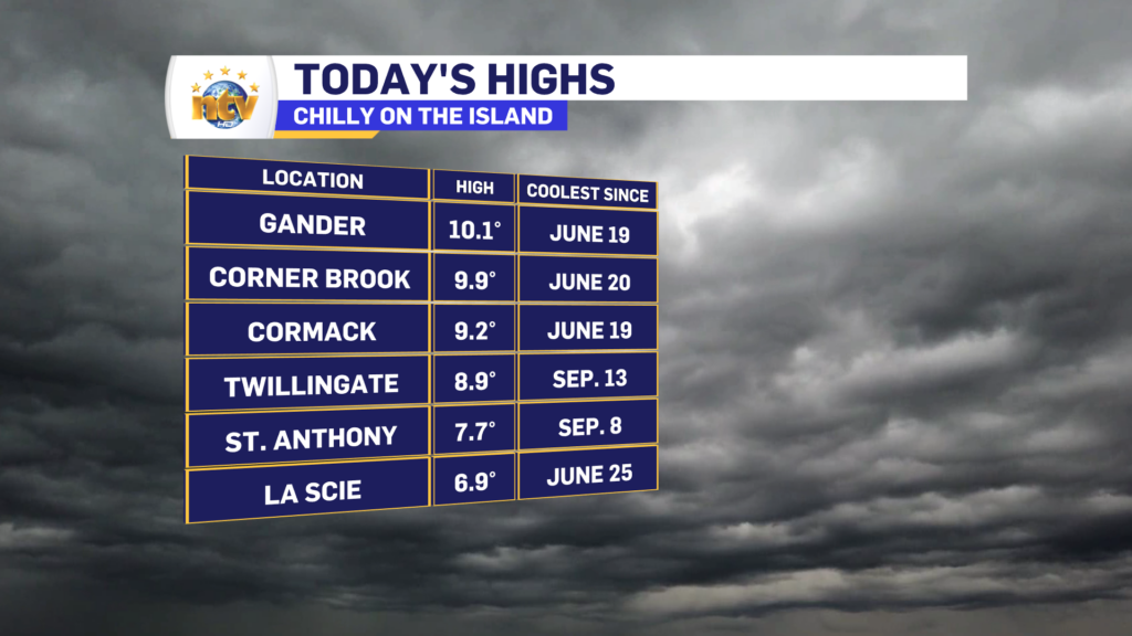
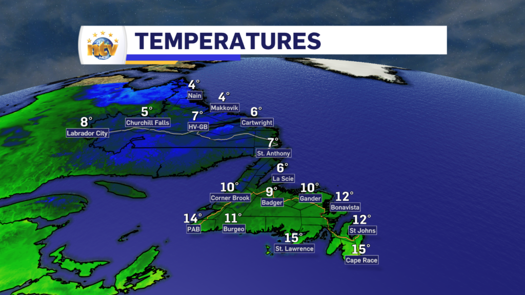
While I don’t expect the frost to be widespread, it is the low-lying interior locations that are at the greatest risk of seeing the mercury drop below freezing tonight. Badger is a location that comes to mind, where we’ve already seen sub-freezing temperatures at least twice this early fall season.

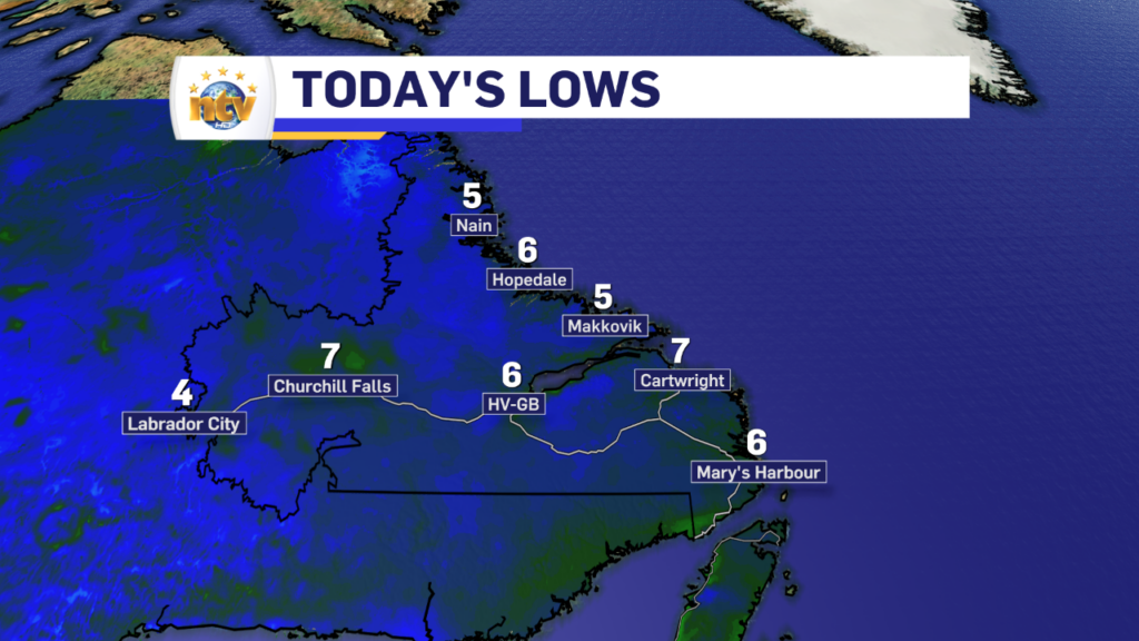
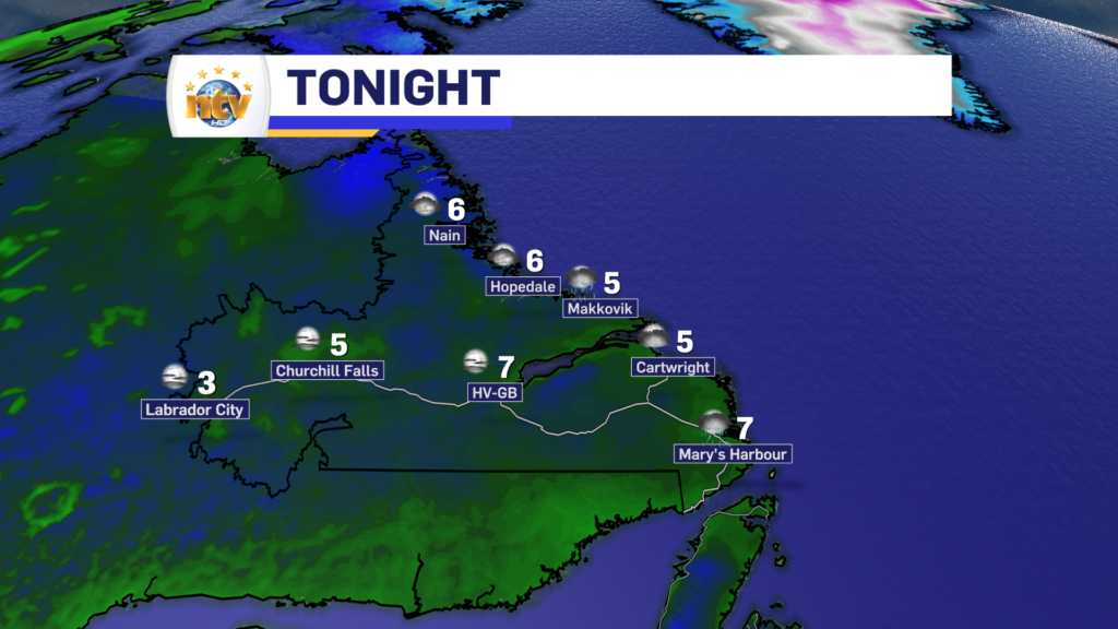
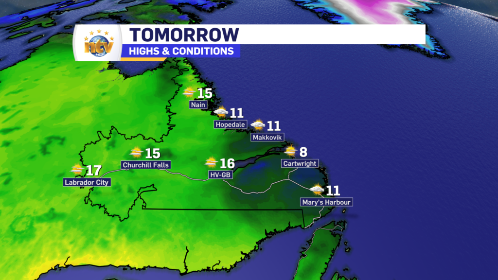
Labrador will generally see lows around 5 to 10 overnight, however in the West readings may dip near freezing come early Friday morning.

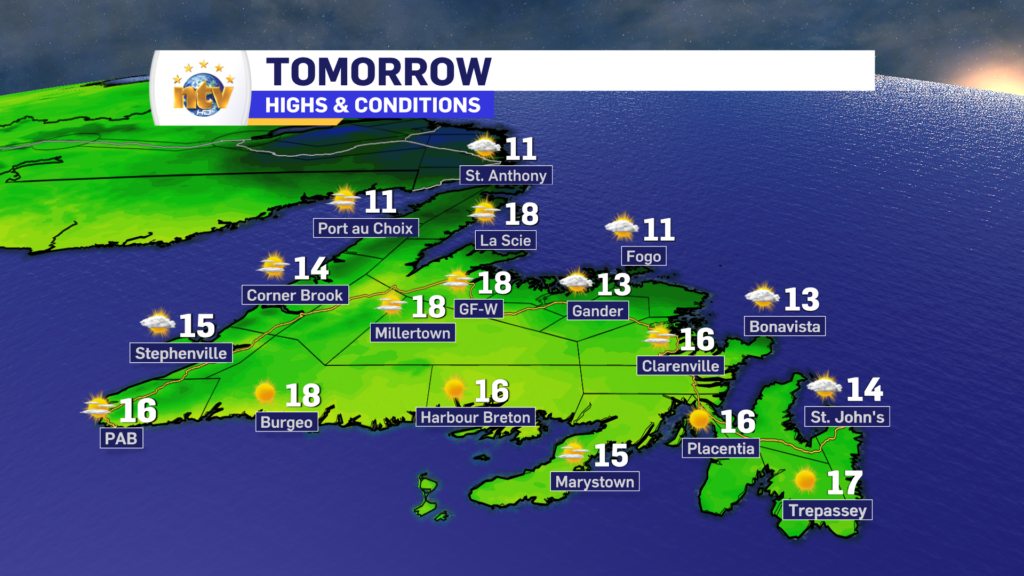
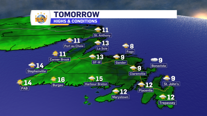
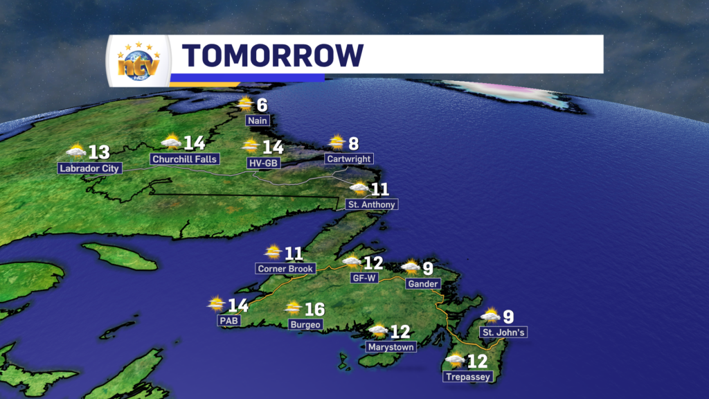
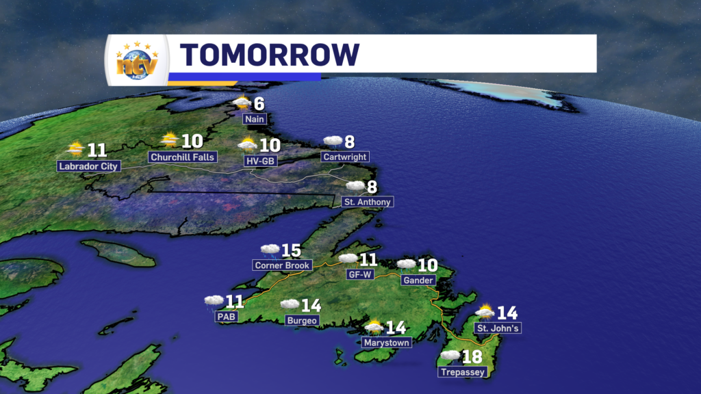
Friday will see sunshine across much of the Province, with the exception being the coast of Labrador. I’m not expecting dense clouds and fog in the area, but some mostly cloudy to overcast skies are certainly a possibility. Highs will be in the middle teens to near 20°.

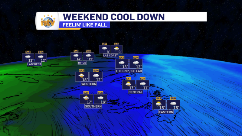
The weekend is looking quite nice, across the province as the area of high pressure continues to dominate the weather picture. The sunshine, mild days, and cool nights will continue. There will be some showers running through the Big Land Saturday night and Sunday and possibly over Western Newfoundland Sunday as well.

Hazy/smokey skies will obscure what would otherwise be a very sunny Thursday

AIR QUALITY ALERT IN EFFECT

Thursday will see mostly sunny skies, with highs in the middle to upper teens across the board. However, there will be wildfire smoke around (which originated in Alta., NWT, and BC) and this may obscure the sunshine somewhat. The result will be white/milkly-looking skies, similar to what we saw Wednesday. The sun will also appear red at sunrise and sunset due to the smoke being overhead.

Friday, Saturday, and Sunday generally look similar across the Province as an area of high pressure remains in control. There will be some showers in Labrador Saturday night and Sunday, and some showers over western Newfoundland Sunday.

The smokey skies should get less intense over the weekend as our weather pattern changes somewhat and should push the smoke from west to east over the region and not north to south. On top of that, the sinking air we are getting downstream of the high-pressure centre over Quebec will become less pronounced.

A hazy, yet mild, Wednesday is on tap for the Province

Good morning! We are certainly off to a bit of a chilly start out there this morning for portions of the interior, central, and western sections of the Island.

Temperatures as of 5:30 AM NDT | September 27, 2023

Some of the lower valleys of interior and western Newfoundland may be seeing some fog this morning as well. That should burn off as the sun comes up and we see the temperatures starting to increase.

Wednesday will generally be sunny to mostly sunny skies across the entire Province. Highs will be in the middle to upper teens, with some areas getting close to 20°. Although skies will be clear, smoke from distant burning wildfires will be in the area and may obscure the sun. The sky will almost look milky white and the sun may appear very red due to the smoke overhead.

The Government of NL, and Environment Canada, have issued an Air Quality Alert through at least Thursday. While much of the smoke will remain aloft, some will make it down to the ground may degrade local air quality. Please follow this link for details on the alert and what that means for your health.

Air Quality Alert is in effect from today thru at least Thursday

The reason for the air quality alert is smoke. Smoke burning from wildfires in Alberta, BC and the Northwest Territories has drifted across the country and due to our current weather pattern, is being directed at Atlantic Canada. The image below shows where our air originated from about 5 days ago, and this clearly shows why the smoke is here.

This image shows where our air came from 5 days ago

Due to the way air moves, especially around a high-pressure centre, which we have overheard, some of this smoke will sink through the atmosphere and reach the ground. While it is not anticipated this will cause widespread poor air quality, locally it may. Which is why the alert (link above) is in effect.

If you’re someone who has a sensitive respiratory system, please take the time to read through that alert and follow your best course of action. Reaching out to your doctor may not be a bad idea as they’ll provide you with proper medical advice on how to deal with the potential smoke.

Tuesday starts chilly, but this afternoon should be lovely!

Good Tuesday morning!

We are off to a chilly start for much of the Island with temperatures in the lower half of the single digits for many areas. I suspect there is definitely some patchy frost, even though Badger was the only ‘official’ weather station to dip below freezing, and as of 5:30 AM NDT is reporting a temperature of -1º.

Morning lows the day of September 26, 2023
Today’s low temperatures | September 26, 2023

A good bit of Labrador is also waking up some chilly temps this morning, with areas in the west also holding between 0º and 5º to begin the day.

This is a map of today's morning low temperatures across Labrador, for September 26, 2023.

The rest of today will generally be quiet and sunny across most of the Province as a ridge of high pressure builds in. Some clouds will push into central, northeastern, and eastern Newfoundland coastal areas during the afternoon and evening, including the St. John’s area. And since the winds are northerly, there *could be* some drizzle in there. I’ll be watching the satellite and radar all day and will have updates as needed. It also looks like the southern coast of Labrador, north of the Straits, from Mary’s Harbour to Cartwright, will also see the clouds stubbornly hanging around today.

The forecast for Tuesday, September 26, 2023. Expect sunshine over much of NL with some clouds moving in later east and central
Today’s forecast | September 26, 2023

Tonight will again be on the chilly side as clear skies and light winds are expected across much of the Island. A Frost Advisory will again be in effect, but this time it’s for southern central and western parts of the Island and lows will be in the -2º to +2º range in low-lying areas.

Frost Advisory for the night of September 26-27, 2023

A quiet week ahead as a large high-pressure centre settles across the region

Tonight’s weather across Newfoundland will be mostly clear with lows ranging from 2 to 6 degrees Celsius. Some areas might experience slightly cooler temperatures with a chance of patchy frost. A Frost Advisory is in effect for much of the Island for tonight.

Frost Advisory for the night of September 25-26, 2023.

Tomorrow, expect sunny skies and mild temperatures in the middle teens, perfect for outdoor activities. However, the eastern and central parts of the island will see some high clouds increasing in the afternoon.

Labrador is in for a cooler night, with temperatures dropping to lows of 3 to 7 degrees Celsius. The western parts of the region will likely see the chilliest conditions. As we head into Tuesday, the Big Land’s weather brings a mix of temperatures, with highs ranging from 8 to 16 degrees Celsius. Coastal areas will be on the cooler side.

The rest of this week looks fairly tranquil as an area of high-pressure sets up shop. Expect highs in the teens and lows in the single digits across the board. Sunshine will be plentiful and overnight will be clear and crisp, with some pockets of fog.

We can thank this tranquil weather to a ridge in the jet stream that is going to be stuck west of the region for the next few days.

Monday starts soggy for some, but it’ll turn around this afternoon!

FROST ADVISORY IN EFFECT FOR TONIGHT

A weak area of low pressure moved over the Island Sunday night and brought yet another round of light rain, after what was an otherwise beautiful Sunday for many. That low will depart today, albeit a bit slower than I’d like to see. This will do a couple of things, it will keep the showers on the go for areas of eastern and northeastern Newfoundland this morning and it will also bring a fairly cloudy morning to the Island. At the same time, much of Labrador will wake up to sunny skies or a mix of sun and cloud.

Throughout the day, the the clouds will eventually clear off for most of the Province, as an area of high pressure builds in from Quebec. This process will yield more and more sunshine as the day wears on. The animation below times out the departure of the clouds.

Temerature-wise today, we are looking fairly seasonble, with highs reaching the upper single digits to lower teens afternoon across the region. Wind speeds will generally decrease as the day wears on and evening approaches.

Friday will be the coolest day in the St. John’s area since late June!

A trough axis is moving through overnight and this will do two things. It will drive rain and showers across the Island overnight into early Friday and push the coolest air of the season as far east as the Avalon as we close out the work week. While the rain we see tonight will not be overly heavy, it will be a little bit of a nuisance. Future radar paints this picture very well. Notice by 7 or 8 AM Friday morning it’s done with.

Highs across the Island tomorrow will struggle to get out of the upper single digits to lower teens. While today was the coolest day since June for many areas of central and western Newfoundland, tomorrow will be the coolest day since that time frame in the east.

Any showers we see in the east will be done with early Friday, while the remainder of the Province will see a very nice day. There will be some showers in Labrador West by the afternoon. Speaking of Labrador West, it will be a cold one tonight. Expect a low near -1 and patchy frost!

Beyond Friday we are in for a decent start to the weekend on the Island, with highs rebounding nicely in the upper teens for Saturday. However, Sunday will be a tad cooler and rain will be widespread in eastern Newfoundland. Labrador West will also see some rain on Saturday.

Eddie’s mid-day update; rain becomes widespread across the Island this afternoon and evening

A trough axis is going to pivot across the Island this afternoon and night and the result is going to be rain becoming more widespread as the day and evening progress. The rain will eventually move off the eastern side of the Island later tonight and early Friday. Future radar, below, shows this very well.

On top of that, while temperatures are quite comfortable today, some areas are currently sitting in the mid-teens on the Island, and cooler air moves in tomorrow.

Temperatures as of 12:30 PM NDT on September 21, 2023

In fact, it’s going to be the coolest day of the month for many. Highs on the Island will only peak in the upper single digits to lower teens, similar to what Labrador is seeing today.

Forecast for Friday, September 22, 2023

Your next forecast update will be this evening!

/Eddie

Eddie’s forecast; will be feelin’ like fall as the weekend nears

Tonight’s Outlook

Expect areas of showers across southeastern Labrador and much of western and northwestern Newfoundland as a trough begins to work its way through. Farther north and west in Labraodr and east and south on the Island, the weather will be calmer and drier. Lows will be near 10 on the Island and range between 2 and 6 in the Big Land, with the coolest readings happening in the west.

Thursday’s Outlook

Rain will become widespread over the Island as a trough swings through. The exception will be in the east and south, where there may be some morning sunshine. However, rain and showers will move in during the afternoon and evening. Highs will be in the lower to middle teens.

Labrador will see the showers wind down in the east, while the north sees sun and clouds and the west sees mostly sunny skies. HIghs range from 6 in the north to nearly 10 elsewhere.

Friday will see a cooler day on the Island with highs of 8 to 10, while Labrador will have highs of 7 to 13. There will be some showers over the Avalon at times on Friday.

The weekend looks unsettled and fall-like across the Province, with chances for showers under sun and cloud. The next chance of heavier rain looks to be over eastern Newfoundland on Sunday.

A summer-like Wednesday is on tap for much of the Island, but not so much in Labrador

The advertised heavy rain band that worked across eastern Newfoundland overnight is in the process of moving offshore. Radar imagery from Holyrood indicates this rather well. And speaking of radar, don’t forget we have a live, interactive radar on our weather page!

Rainfall totals across a large part of southern and eastern Newfoundland, going back to last night, are generally between 15 and 30 mm, with lesser amounts through Central and parts of the West Coast.

Behind the rain, we will get a brief surge of warm air to move across most of the Island, along with breaks in the cloud cover. The exception will be on the Northern Peninsula, where rain lingers through much of the day, and on the West Coast, where showers will be numerous this afternoon. Highs reach the upper teens to lower 20s for a large contingent of the Island south of the GNP.

Much of southeastern Labrador will see the rain continuing throughout the day. Highs reach the upper single digits for most areas. And there may even be some snow in the higher elevations!

I’ll have your updated long-range forecast later today!

Scroll to top