weather forecast

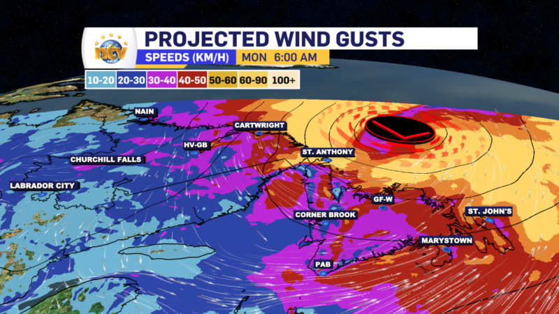
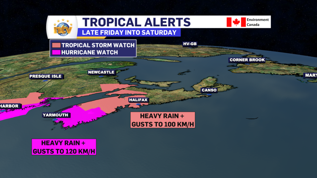
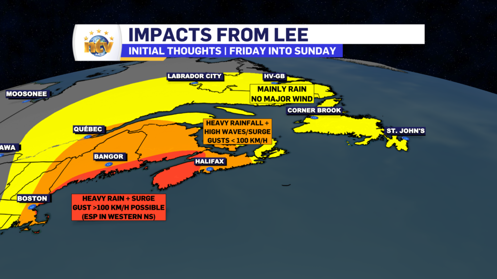
Eddie’s Forecast: A rainy Tuesday night will be followed by a summer-like Wednesday on the Island

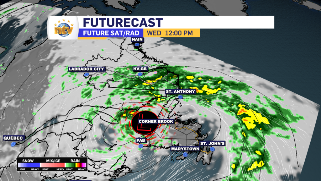
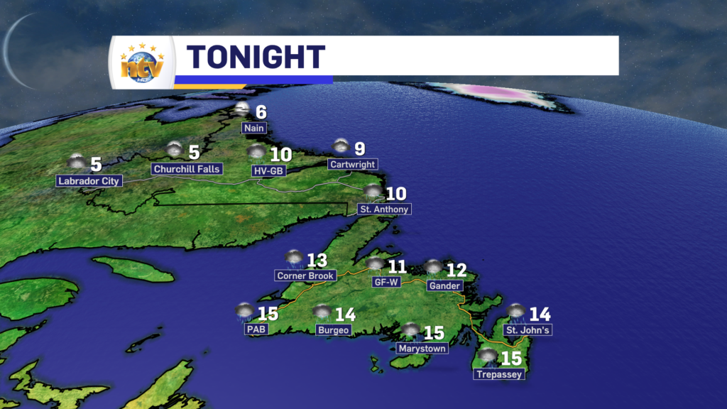
An area of low pressure will swing through the region overnight into Wednesday. This will drive rain across the Island and into southeastern Labrador during the time frame. In Labrador, the rain will move in overnight and continue into Wednesday. There may even be some snow in the higher terrain of the Mealy Mountains, as temperatures will only be in the upper single digits in the lowlands.

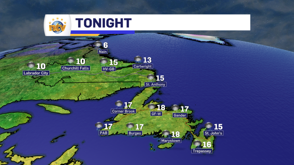
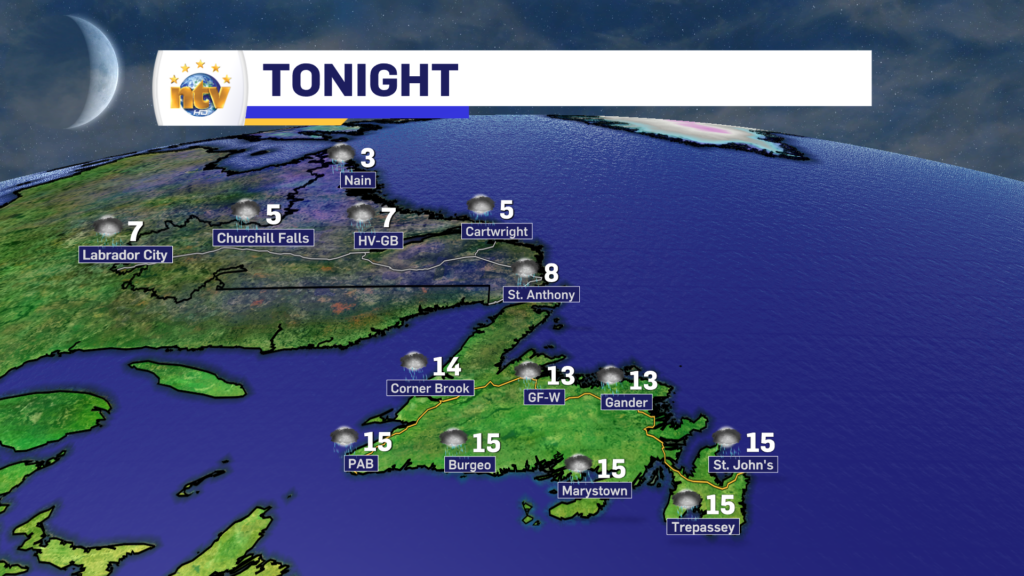
On the Island, we are seeing rain this evening in many areas. The rain will get heavier over eastern Newfoundland tonight, while central, western, and southern areas see it taper off after midnight. The GNP will also see the rain become heavier overnight. On the Avalon, we can expect a band of very heavy showers to move through early Wednesday morning, in the 4 to 7 AM range. This may very well wake you up and there is even the chance for some thunderstorms. Lows on the Island will be in the lower to middle teens.

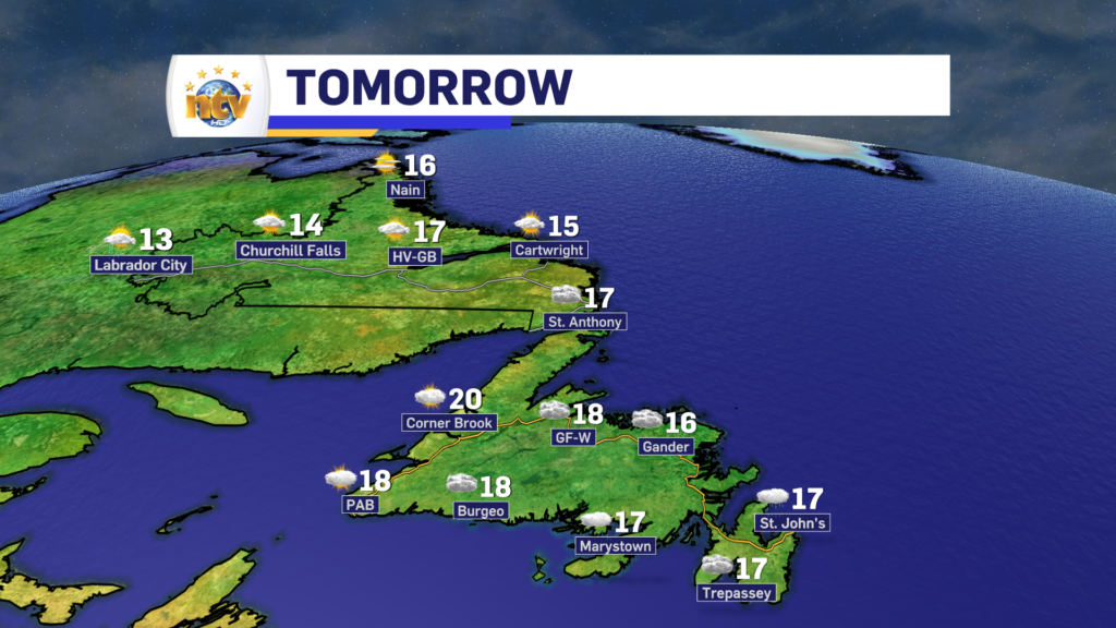
The area of low pressure will swing across the Island during the day Wednesday. This will keep the rain ongoing for the GNP and southeastern Labrador, while much of the Island will get into the warm sector, or right-hand side, of the low.

This means partly to mostly cloudy skies will be the rule, with highs in the upper teen lower 20s. There also will be some scattered showers, particularly over central and western areas during the afternoon. Meanwhile, on the colder side of the low, highs in Labrador and the GNP will be in the lower teens.

Thursday will start dry on the Island, however, a trough will swing through during the afternoon and overnight. This will drive an area of light rain to develop on the West Coast and work eastward Thursday afternoon and overnight into Friday morning. Many of us will see at least some rain during that time frame.

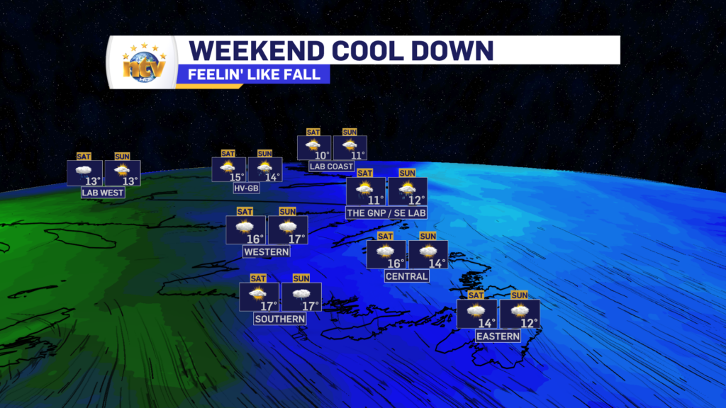
The rain is on the leading edge of some fall-like air which will settle in for the weekend. Highs for much of NL will only reach the lower to middle teens from Friday through Sunday. At the moment the weekend looks cool and dry, but there is a chance of rain on Sunday and possibly Monday. But I’ll update you on that later in the week.

Tuesday morning update; rain arrives later today

Tuesday’s Outlook

An area of low pressure will move from the northeastern United States into the Maritimes on Tuesday, which will push rain onto the Island during the second half of the day. The rain will arrive in the early afternoon on the South Coast and by 6 PM, or later, almost everywhere else. Winds will also be out of the east, so fog is a good bet for eastern coastal areas. Highs will be in the middle teens.

Labrador will see clouds on the increase and scattered showers. However, that’s about it. Expect highs of nearly 7° in the north to lower teens elsewhere.

Forecast for Tuesday, September 19, 2023

Tuesday night will see the rain spread across the Island and it will become heavy at times over the eastern two-thirds of it. This will be especially true over the Avalon, Burin, and Bonavista Peninsulas where the heaviest rain looks to fall during that time frame. Rain will also push into the southeast part of the Big Land from Goose Bay to Cartwright, points south.

The rain will ease off Wednesday morning as a warm front lifts north. That will push a short-lived shot of warm and humid air back over the Island, and highs will rise into the upper teens to lower 20s for many of us. And there will likely be some afternoon sunshine.

Meanwhile, rain will continue on the southeast corner of Labraodr and that will not fully taper off until Wednesday night. Highs in Labrador on Wednesday will be in the 8 to 12 range.

Futurecast for 12 PM Wednesday – September 20, 2023

Beyond Wednesday the weather looks to remain a bit unsettled for the remainder of the week, and more fall-like and cooler air takes hold. Expect another chance of rain and/or showers on Thursday over the Island, with a dry day on tap for Friday and more showers for the weekend. Highs will dip into the lower teens to close out the week, which means fall-like attire can be broken out!

The northern lights may make an appearance tonight before the rain arrives on the Island on Tuesday

Tonight’s Outlook + The Northern Lights

The weather across the Province will be relatively calm overnight, ahead of an area of low pressure which will start to swing in Tuesday. Lows will be in the 4 to 8 range in Labrador and 9 to 16 range on the Island. The warmest readings will be in the east and south.

NL Forecast for tonight – night of September 18-19, 2023

Clouds will be more hit than miss overnight, which is unfortunate because the northern lights may make an appearance over much of the Province. A geomagnetic storm is underway and Kp values may be as high as 6 tonight. While that may not seem like anything important, Kp values of 6 mean that areas as far south in the Province as the Avalon and almost the South Coast, have a chance of seeing the lights IF skies are clear. And tonight that’s a big if.

Kp values for tonight may be as high as 6 – Overnight between September 18 and 19, 2023

The best way to see the northern lights is to find a dark sky with a clear view of the northern horizon. With respect to tonight, I don’t have an idea of what time may be best yet. I may have a better idea after sunset and the auroral activity starts to swing our way.

Tuesday’s Outlook

An area of low pressure will move from the northeastern United States into the Maritimes on Tuesday, which will push rain onto the Island during the second half of the day. The rain will arrive in the early afternoon on the South Coast and by 6 PM, or a tad later, almost everywhere else. Winds will also be out of the east, so fog is a good bet for eastern coastal areas. Highs will be in the middle teens.

Labrador will see clouds on the increase and scattered showers. However, that’s about it. Expect highs of nearly 7° in the north to lower teens elsewhere.

Forecast for Tuesday, September 19, 2023

Tuesday night will see the rain spread across the Island and it will become heavy at times over the eastern two-thirds of it. This will be especially true over the Avalon, Burin, and Bonavista Peninsulas where the heaviest rain looks to fall during that time frame. Rain will also push into the southeast part of the Big Land from Goose Bay to Cartwright, points south.

The rain will ease off Wednesday morning as a warm front lifts north. That will push a short-lived shot of warm and humid air back over the Island, and highs will rise into the upper teens to lower 20s for many of us. And there will likely be some afternoon sunshine.

Meanwhile, rain will continue on the southeast corner of Labraodr and that will not fully taper off until Wednesday night. Highs in Labrador on Wednesday will be in the 8 to 12 range.

Futurecast for 12 PM Wednesday – September 20, 2023

Beyond Wednesday the weather looks to remain a bit unsettled for the remainder of the week, and more fall-like and cooler air takes hold. Expect another chance of rain and/or showers on Thursday over the Island, with a dry day on tap for Friday and more showers for the weekend. Highs will dip into the lower teens to close out the week, which means fall-like attire can be broken out!

What’s left of Lee swirls away, leaving improving weather in its wake for our Monday

What’s left of Post Tropical Storm Lee is swirling in the North Atlantic this morning north of Newfoundland and east of Labrador. The broad circulation around the low is driving some gusty winds across parts of coastal Labrador, along with some areas of the Island from the Great Northern Peninsula to the Avalon.

Wind gusts across NL as of 630 AM this morning.
Wind gusts as of 6:30 AM NDT / 6 AM ADT

As the remnant low of Lee departs throughout the day, the wind speeds will drastically come down across the Province, leaving a much calmer late morning and afternoon for you to enjoy!

Today's forecast for NL. This is for Monday, September 18, 2023
Monday’s NL Forecast | September 18, 2023

Our Monday will see a mix of sun and cloud over much of the Island, with highs ranging from near 10º in the north to nearly 20º, or a bit better, in the south and southeast. The difference today will be the air mass will not be as humid, so even though temperatures will be similar to the last few days, it will not be nearly as muggy. There may be a few scattered showers this afternoon.

Labrador will see highs near 10º today, with areas of scattered showers… and dare I say, high-elevation flurries. It may seem early for many… but that’s probably not unusual for the Big Land this time of year, especially on the back side of a Post Tropical Storm, which often pulls down some cooler air.

The Next One

The next area of low pressure in the pipeline arrives tomorrow. This will spread rain across the Island during the second half of the day. This low will bring rain into Wednesday for parts of central, east and northwestern Newfoundland and eventually southeast Labrador as well. Long story short… Tuesday and Wednesday don’t look great at this point.

RDPS model shows rain working across the Island Tuesday afternoon and evening.
RDPS MSLP and Precipitation Forecast for 9:30 PM Tuesday, September 19, 2023

Your next update will be this afternoon!

/Eddie

Saturday’s weather brief: Lee brings severe weather to the Maritimes, while NL waits for remnants to arrive Sunday

The weather across NL today will be quite calm in comparison to our Maritime neighbors. We can expect cloudy skies on the Island, with areas of dense fog for some eastern and northeastern areas where winds are onshore and easterly to begin the day. As the day goes on, the wind direction should shift to more a southerly or southeasterly one, which should dissipate some of the fog for eastern areas but will cause it to become more widespread in the south. Showers arrive on the West Coast and the Southeast Coast, in association with Lee later today. Highhs on the Island reach the upper teens to lower 20s.

Meanwhile, in Labrador today expect increasing cloud and highs in the single digits in the north to teens inland and in the southeast.

Today’s forecast for NL – September 16, 2023

While most of the Island will not see severe wind speeds, the Wreckhouse is the exception. A Wreckhouse Wind Warning is in effect from this afternoon into Sunday morning for gusts of 100 km/h.

POST TROPICAL STORM LEE UPDATE

As of the 6:30 AM NDT advisory, the National Hurricane Centre based in the United States has classified Lee as a Post-Topical Storm. While the naming convention makes it seem like it may be a less powerful storm, that’s not the case. It will still bring severe impacts to Nova Scotia, New Brunswick, PEI and parts of Quebec as the day goes on.

Lee’s currents as of 6:30 AM NDT on Saturday, September 16, 2023


Lee will make landfall later this morning or early this afternoon somewhere in western Nova Scotia. However, ultimately, it will not matter as the storm is so large impacts are going to be felt well away from the centre.

Lee’s forecast rack thru Sunday

Tropical Storm, to Hurricane force wind gusts will be felt along the coast of Nova Scotia today. Gusts may peak as high as 120 km/h in some areas east of Lee’s center. That does include the Halifax area. High waves and storm surge are also a concern along the coast with today’s high tide. Heavy rain will also fall north and west of Lee’s centre, where over 100 mm will fall in some locations. The weather in the Maritimes will dramatically improve later today and tonight as Lee departs.

In NL, the impacts we see from Lee will be decidedly less severe. However much of western Newfoundland and parts of southeast Labrador will see heavy rainfall later tonight and Sunday. Parts of Labrador will see over 50 mm of rain. Some areas along the West Coast, GNP and southeast Labrador will see wind gusts to 60 or 80 km/h, however, that’s nothing unusual with most lows that swing through.

As with any system that has a large circulation, especially tropical ones, storm surge and high water levels is a concern. Areas along the South Coast of Newfoundland from near Burgeo to Cape Race should keep an eye out for higher than normal water levels with Sunday night and Monday morning’s high tide. I do not expect major coastal flooding, but minor water issues are possible in some areas.

Stay tuned for more updates!

A mild and showery Friday will close out the workweek as Hurricane Lee nears the region

An area of low pressure will move across Labrador overnight and that will drive some rain across the Big Land and into western sections of the Island along a cold front. There may even be some isolated thunderstorms as well. Areas of central and eastern Newfoundland will see showers arrive late, but that will be about it. Lows will be in the middle teens for most of the Province, except in northern Labrador, where it will be closer to 6°.

NL Forecast for tonight, September 14, 2023

Friday will see morning rain and/or showers over the West Coast of the Island and even into Central and much of the South Coast. Those will end as the rain moves east and the skies will clear in the afternoon. Areas of eastern and northeastern Newfoundland will remain mainly cloudy, with scattered showers for the last day of the work week. Coastal Labrador will be the same, however sun and cloud return to the west.

Highs on the Island will be in the upper teens to middle 20s and it may be a little humid too. Labrador will see highs ranging from 10° in the north to 18° in Goose Bay and southeast coast and closer to the lower teens in the west.

NL forecast for tomorrow, September 15, 2023

Rainfall amounts will be locally significant in parts of southeastern Labrador and along the South/West Coasts of the Island where heavy downpours move through overnight into early Friday morning. Beyond that, widespread significant rainfall isn’t expected.

Rainfall totals – tonight thru Friday at 7 PM – September 14-15, 2023

The weekend will see some showers on the Island Saturday, while clouds will be on the increase in Labrador during the afternoon. Rain and showers will move in Sunday, as what’s left of Hurricane Lee approaches the region. The remnant low of Lee will move past the Island on Monday. At this point, while heavy rain and breezy conditions will accompany the low, widespread severe impacts aren’t expected in NL.

Hurricane Lee’s 5-day Forecast – September 14, 2023

Our neighbors in the Maritime Provinces, particularly in parts of western Nova Scotia and New Brunswick will not be so lucky. Hurricane and tropical storm force wind gusts (100 to 120 km/h) will be felt for a large area where Tropical Storm and Hurricane Watches are now in effect. 3

Tropical Weather Alerts as of 5 PM NDT on September 14, 2023

Along with that will come some very heavy rainfall Friday night into early Sunday, with some parts of western Nova Scotia and New Brunswick seeing as much as 150 mm of rain. There will also be some coastal flooding due to high waves and storm surges along the coast of Nova Scotia and into parts of the Bay of Fundy.

Potential Impacts from Hurricane Lee – Posted September 14, 2023

While I’m not currently expecting widespread storm surge in Newfoundland, I do expect some high waves to move past the southern shorelines Sunday night into early Monday. This may result is some tidal flooding at high tide Sunday night and early Monday morning. Particularly for low-lying areas from the Connagire Peninsula to the southeast Avalon (Cape Race).

Eddie’s Thursday morning update; Island clouds and Labrador rain today

Good Thursday morning! We are off to another cloudy and gray start across a large part of the Island this morning. I wish I had better news for you, but this will be how it stays for most of us today. The exception will be parts of the West and southwest coast, where there should be some sun throughout the day. Parts of the GNP, particularly the western side, should be the same.

The reason for this, as has been all week, is the area of high pressure to our east. This will move a bit more today away from us and allow the wind to turn a bit more southerly. This should ease the fog and drizzle for eastern shores and shift it more to the south-facing coastlines.

Meanwhile, in Labrador today, a slow-moving area of low pressure will work its way in. This will drive rain across the region throughout the day, and it will work from west to east. There may be some breaks this afternoon, but more is on the way for tonight and parts of Friday. The Island will also see rain from later tonight into Friday as well.

Temperatures today will peak into the teens to near 20 across N.L. Futurecast (below) does a good job of showing how this will play out.

Futurecast for today, September 14, 2023

If you’re looking for an update on Hurricane Lee, here is an article I put up last night. Not much has changed and I’ll have another update for you later today.

Wednesday morning’s forecast; more of the same

An area of high pressure north of the Island is going to keep the onshore, easterly flow, on the go for the next couple of days. While this will not result in significant weather rolling into the Island, it will keep the skies cloudy, drizzle frequent, and fog possible along and near east-facing shorelines.

Today will be similar to today across the Island. We can expect more showers, clouds, drizzle, and fog thanks to the onshore flow. Highs will be in the middle to upper teens. There may be some sunny breaks on the West Coast and southwest coast, and the western side of the GNP.

Labrador will see a decent day, with highs in the middle teens under sun and cloud. There will be some showers in the west late in the day.

NL Forecast for today, September 13, 2023

Looking into Thursday and Friday, the weather generally doesn’t change a whole lot on the Island as the wind direction remains the same. There will be some rain in Labrador on Thursday and potentially again in the west on Friday. Highs remain in the teens and may creep toward the 20s in some areas to close out the work week.

Eddie’s forecast: More clouds than sun will be the rule for Wednesday + an update on Hurricane Lee

An area of high pressure north of the Island is going to keep the onshore, easterly flow, on the go for the next couple of days. While this will not result in significant weather rolling into the Island, it will keep the skies cloudy, drizzle frequent, and fog possible along and near east-facing shorelines.

Lows will be in the lower to middle teens on the Island overnight, and areas of drizzle will be common for most areas, but it’ll be most prevalent along and near east-facing shores. Fog will also be around too.

Meanwhile, in Labrador, expect partly cloudy skies and lows of 6 to 10 tonight.

NL forecast for tonight, September 12, 2023

Wednesday will be similar to today across the Island. We can expect more showers, clouds, drizzle, and fog thanks to the onshore flow. Highs will be in the middle to upper teens. There may be some sunny breaks on the West Coast and southwest coast, and the western side of the GNP.

Labrador will see a decent day, with highs in the middle teens under sun and cloud. There will be some showers in the west late in the day.

NL Forecast for tomorrow, September 13, 2023

Looking into Thursday and Friday, the weather generally doesn’t change a whole lot on the Island as the wind direction remains the same. There will be some rain in Labrador on Thursday and potentially again in the west on Friday. Highs remain in the teens and may creep toward the 20s in some areas to close out the work week.

As we look ahead to the weekend, all eyes will shift to Hurricane Lee, which as of this writing, is still a category 3 hurricane about 900 km south of Bermuda.

Hurricane Lee Stats as of 3:30 PM NDT on September 12, 2023

Lee will turn north in the next 24 hours and begin to gain latitude, accelerate in speed, and lose strength as it leaves the warmer waters behind. Current indications are that Lee will track to the north and make landfall late Friday or early Saturday anywhere between Nova Scotia and Maine.

While there is agreement on where the storm is going to go, to a point, we still don’t know where it will go and thus where the highest winds, heaviest rain, and highest waves will be. All of that will determine where the greatest risk for flooding and power outages lies. That will get more clear in the next couple of days.

What I do know is that NL looks to be outside of the direct impacts from the system, for the time being. It does look like we may see some rain and gusty winds from Sunday into Monday and the remnants pass over the Province. However, and again at this time, this should be nothing out of the ordinary for the Province.

Stay tuned for more updates.

A soggy Tuesday is on tap for southeastern Newfoundland, and everywhere else… not so much

Our Tuesday morning is certainly starting off on the soggy side for the Avalon and Burin Peninsulas. The rain is falling heavily over the Avalon as of this writing (6:43 AM NDT) but is lighter farther west onto the Burin Peninsula. Rainfall amounts overnight were highest on the Boot. Winterland is reporting 13.3 mm since last night.

Radar imagery as of 6:46 AM NDT shows the heaviest rain over the northeast Avalon. The rain is heading east.
Radar snapshot as of 6:46 AM NDT on September 12, 2023

The rest of the day will generally see the rain persisting over the Avalon and Burin Peninsulas, although it should be a bit lighter than it is this morning. The Connaigre Peninsula and parts of the South Coast will also see the rain today.

Meanwhile, the rest of the Island will see predominately cloudy skies today, except on the GNP, where some sunshine will be found. Highs will be in the teens.

Labrador will also see a mix of sun and clouds through most of the day, however, some showers roll into western areas this afternoon and may arrive in Goose Bay by evening.

Scroll to top