weather forecast

Eddie’s Monday evening forecast; rain continues into Tuesday in the southeast + an update on Hurricane Lee

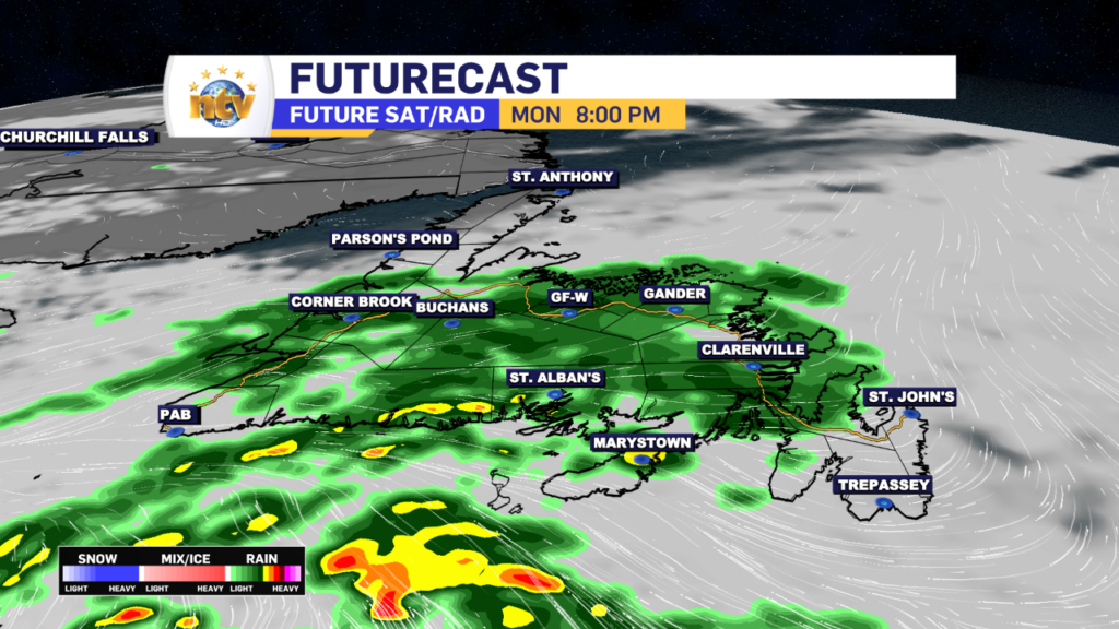
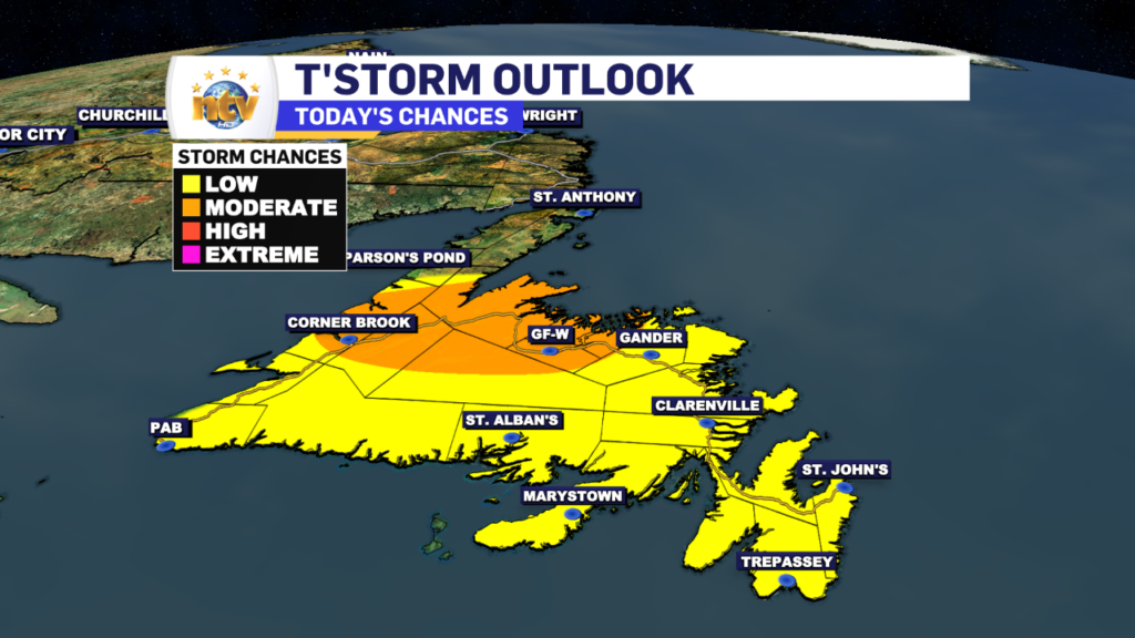
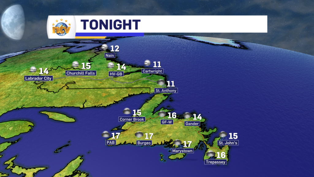
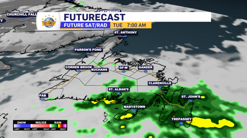
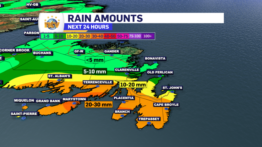
A frontal boundary is going to get situated over southeastern Newfoundland tonight and linger in the area through Tuesday. Ahead of this boundary, rain is falling this evening over much of the Island south of the Great Northern Peninsula. The rain will over western and central areas overnight but will continue in the east and southeast. In fact, in those areas, the rain will continue until Tuesday before ending. Rainfall amounts from the Connaigre Peninsula to the Avlaon will total 20-30 mm in some areas, by late Tuesday.

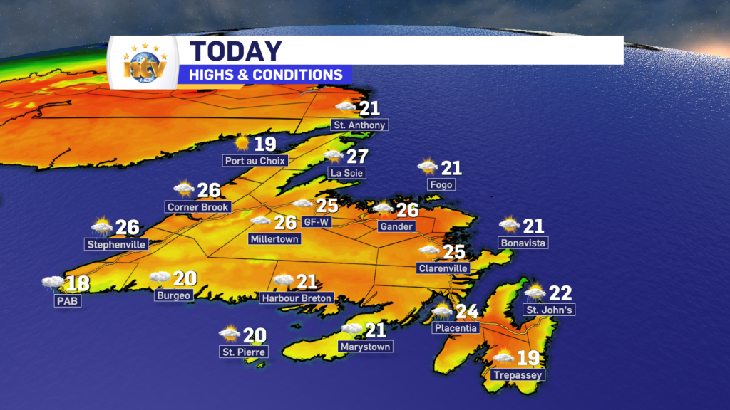
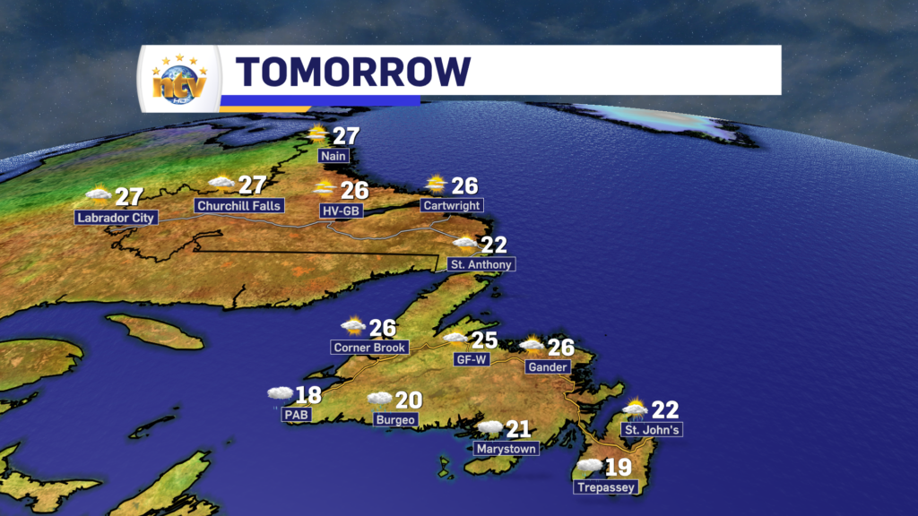
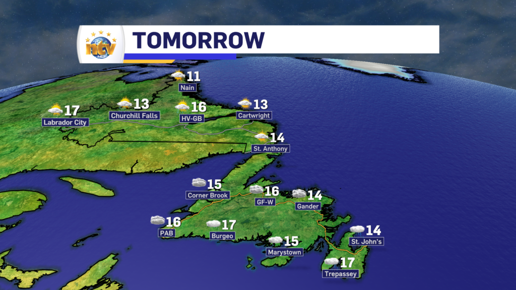
While eastern Newfoundland will see the rain continue for Tuesday, the rest of the Island will generally see cloudy skies. Except on the GNP, there it will be partly to mostly cloudy. Labrador will also see a mix of sun and cloud for Tuesday, with some showers working their way into the west during the afternoon.

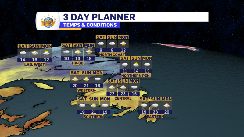
High temperatures across the Province will be in the teens for the second day of the work week.

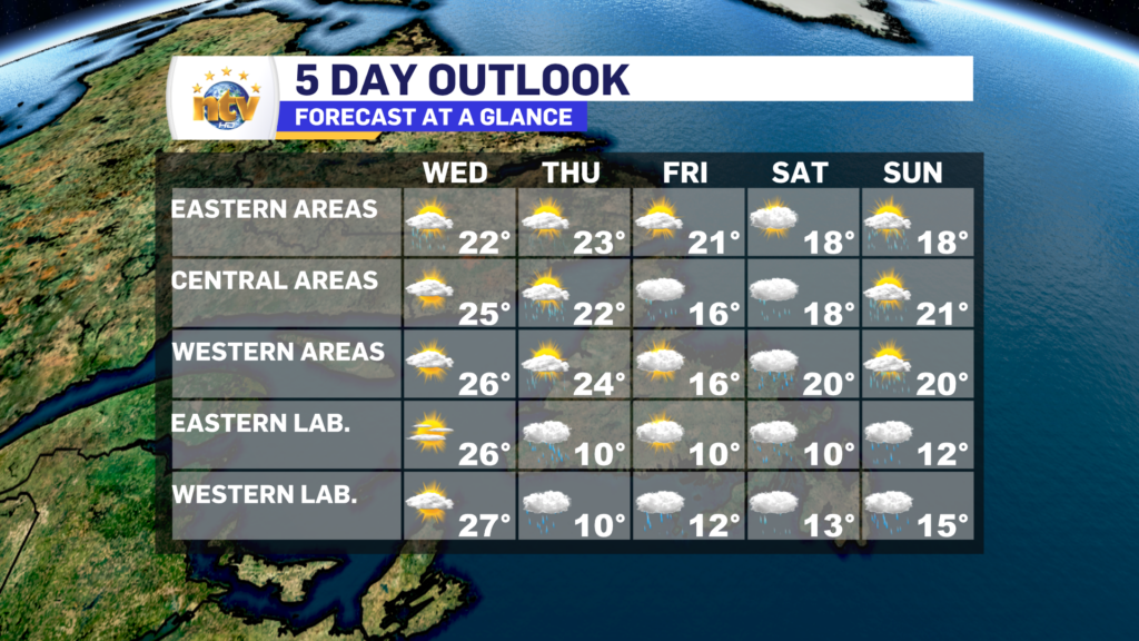
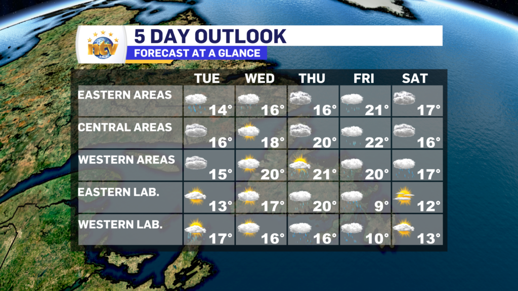
Beyond tomorrow, the weather this week across much of the Province looks to be cloudy and unsettled, with chances for rain and showers through Saturday. Temperatures remain in the teens to lower 20s and the primary wind direction remains from the east nor northeast.

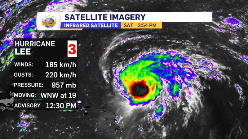
Hurricane Lee Update

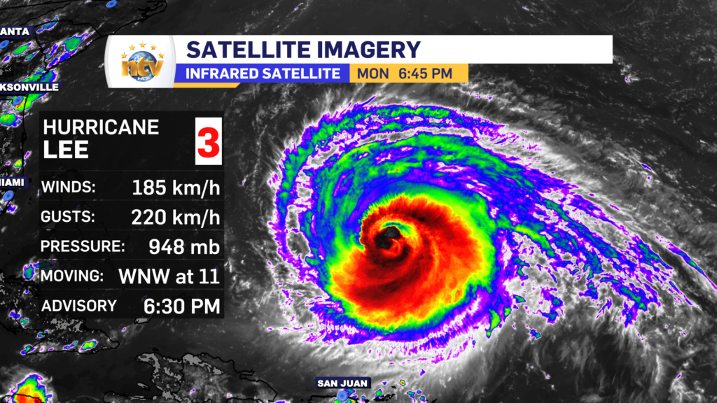
As of 6:30 PM NDT, Hurricane Lee is a category 3 hurricane on the Saffir-Simpson scale, with sustained wind speeds of 185 km/h. The storm is heading west-northwest at 11 km/h and will generally maintain that course through Tuesday before making a turn to the north.

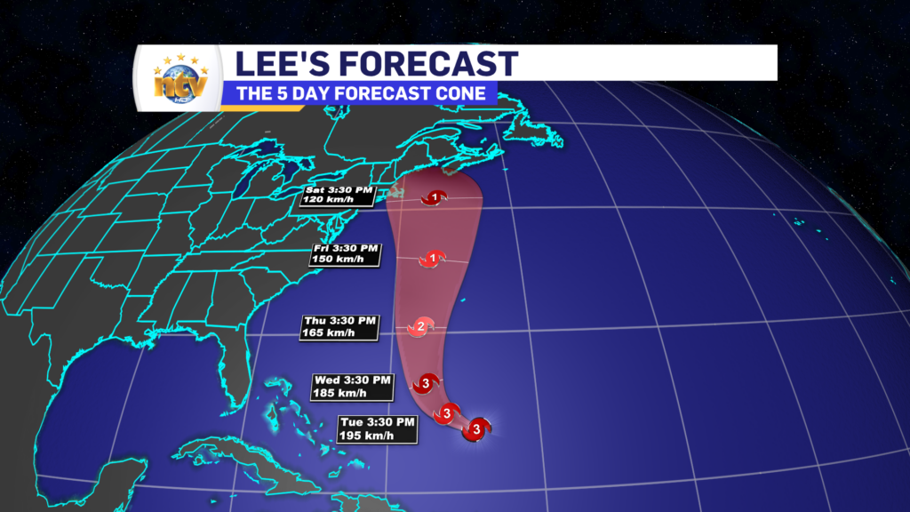
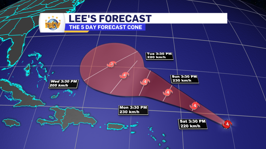
At this point, the forecasts are keeping Lee on a northerly track through Saturday, and current projections have the centre of the storm anywhere from Cape Cod to western Nova Scotia by Saturday afternoon. Keep in mind, the width of the cone above indicates where the centre of the storm will be, not the size of it.

At this time it it is still too early to talk about potential impacts, but you can expect high waves, rain, and wind to be approaching the region next weekend. Where each will be set up is still unknown but that will get clearer over the coming days. Stay tuned!

Monday’s forecast; Cloudy and drizzly on the Island, while Labrador sees a pretty nice day

The morning is starting off cloudy and a bit foggy for the Island, as northerly and onshore winds have taken hold. Throughout the day, that will not change much… in fact, rain will spread across the Island from southwest to northeast later today and this evening. This is due to a weak frontal boundary lifting north, over the Island.

Meanwhile, in Labrador, expect a mix of sun and cloud today, with highs in the teens. Pretty straightforward forecast for the Big Land!

I’ll have your next update later today!

/Eddie

Eddie is monitoring Hurricane Lee closely, however, it is still not known if the storm will impact the region

Hurricane Lee is still swirling north of the Caribbean Island this afternoon but is a bit of a weaker storm. The latest analysis from the National Hurricane Centre in the US shows winds of speeds of 185 km/h, making the storm a category 3 on the Saffir-Simpson scale. The storm is still heading toward the west-northwest at 19 km/h and will generally remain on that trajectory for the next few days. Some fluctuations in strength are likely to occur as the environment for the storm isn’t ideal.

After Tuesday, Lee will start to get pushed north as the atmospheric steering currents begin to force it that way. Once it makes the shift, the storm will likely hold, or start losing intensity, as the forward speed increases during the mid part of next week.

Beyond 5 days, no matter what you’re seeing today, it’s still too soon to get into specifics on where Lee will go. As of this writing (4:02 PM NDT) a wide variety of solutions are still on the table that could take the center of the storm anywhere from New England (Northeast USA) to Newfoundland or even the Grand Banks and anywhere between.

Once the storm starts to make the turn, and we can see how it will interact with another weathermaker swinging out of the eastern United States, I will have a better idea of where it’s going to go. Keep in mind that’s still 5 days from now, and any impact to our region, if it happens, will be about a week from now.

Please continue to monitor forecasts and updates on the storm.

The weekend forecast; we’ve had better.

The weather across the Province be half not-so-good on Saturday and half-decent for some areas on Sunday. Our Saturday will see areas of rain pushing through Labrador, and even some snow in the higher elevations of the North Coast. While on the Island, predominantly cloudy skies will be the rule, with areas of showers on the West Coast, GNP, and into parts of Central. Highs range from the lower teens in Labraodr to middle teens to nearly 20 on the Island. The warmest readings on the Island will be in southeastern areas.

Sunday will see a decidedly quieter day across the region, with cloudy skies remaining more of the rule than the exception. Although we should see some sunny breaks in spots for the second half of the weekend. Highs range from the teens in Labrador to the upper teens to nearly 20 on the Island.

Next week looks fairly normal, weather-wise with some chances for rain, again, on Tuesday. Beyond that, it looks decent enough.

Hurricane Lee's 5 day forecast cone. The storm will remain strong and track north of the Caribbean Islands before slowing

All eyes are on Hurricane Lee, but it’s too early to get into any specifics on the right now. We just need to watch and the forecast will get a bit more clear early next week. If it does end up coming our way, the timing looks like late next week or next weekend. if I need to start talking about hazards and impacts that would happen during the second half of next week.

Have a great weekend.

Eddie

Some areas of the Island turn cooler for Friday, as clouds, showers, and rain hang around the N.L.

What’s left of Idalia will swing across the Island overnight into early Friday, before moving offshore. This will drive more showers on the Island into the overnight period, along with the risk of isolated thunderstorms. The showers become a little less widespread for Friday as winds turn northerly for the western 2/3 of the Island. That will also signal a cool down, with highs reaching the middle to upper teens. However, in the east and south, we will not be as lucky. Another day of warm and humid weather is on tap, with mostly cloudy to cloudy skies.

Labrador will see the rain stick around overnight and Friday, with temps holding in the upper single digits to lower teens.

The weather pattern remains active through the weekend and I break your forecast down in the video at the top of the post.

Have a great night!

Eddie

Thursday morning update; another muggy day for the Island, not so much in Labrador

Before we speak about Thursday, let’s delve into Wednesday a bit. Wednesday is warm hot and humid across the entirety of the Province. Multiple areas had highs in the upper 20s to lower 30s as temperatures ran more than 10º above normal in some areas!

On top of that, over the last couple of days, we’ve set some all-time September record highs in a few spots across Newfoundland and Labrador.

Now for today… that warm party is over in Labrador as a much colder air mass moved in overnight. Temperatures fell sharply and much of the Big Land is waking up to reading in the lower teens this morning. Check out the loop of temperatures over the last 24 hours.

Thursday across the Province will see rain over much of the Big Land and cooler temperatures. While on the Island we see areas of showers and thunderstorms, along with another warm and humid day. Highs should be in the lower to mid-20s, but if we get more sun than I think we are going to, mid to upper 20s are possible once again. Futurecast (below) should show this well.

There is a chance of thunderstorms today across much of the Island, particularly for areas west of Grand Falls-Windsor to near Corner Brook.

I’ll have a more detailed weather update this afternoon!

Have a great day!
Eddie

The muggies make a return for Wednesday, as do the showers

Good Wednesday morning! And for parents and kids, welcome to the 2023/24 School Year!

As what’s left of Gert, spinning east of Nova Scotia this morning drifts a little more to the west, the wind direction across the Island will turn more southerly over the Island, compared to eastern and northeasterly on Tuesday. This will cause a few things to happen;

  • We will see the showers and fog shift from the east coast to the South Coast of the Island
  • The air will turn significantly more muggy as we are getting into an airmass that has Florida origins.

Humidex values over a large part of Central and eastern Newfoundland will cruise into the upper 20s to lower 30s today.

Even though the calendar says September, it’s still going to feel like the Dog Days of Summer.

Labrador will see very warm temperatures today as well, with highs across the region soaring into the middle and upper 20s.

The air over the Big Land will be unseasonably warm with highs running over 10ºC above normal in some areas!

This will not last, however, as a cool down is on the way for later tonight and tomorrow as a cold front sinks southward. I’ll have a further update on this, and Tropical Storm Lee for you later today.

Have a good one!

Eddie

Will be feelin’ like summer on the first day of school

The remnants of Tropical Storm Gert are spinning south of Newfoundland and east of Nova Scotia this evening. That is driving broad, easterly flow, across much of the region today. That setup has brought fog to eastern sections of the Island, while the West Coast, Southwest Coast, and much of Labrador have seen sunshine and highs in the middle to upper 20s, to near 30°!

For tonight we will see scattered showers around this low on the eastern and southern side of the Island. Otherwise, we can expect almost clear skies across the Province. Lows will be into the middle teens on the Island and lower to middle teens in Labrador.

Wednesday, the first day of school in the 2023 school year, will see morning showers in eastern Newfoundland shift toward the south and southwest coast in the afternoon as the wind direction turns from easterly to southerly. Expect highs on the island int he 20 to 26 range, with the coolest readings being found south. It will also be muggy, with humidex values approaching the upper 20s to lower 30s in some areas. Labrador will see highs in the middle to upper 20s, however, clouds will be on the increase in the north and west during the afternoon as a cold front begins to approach the area.

Thursday will see more showers on the Island, along with some sunny breaks and the odd thunderstorm possibility as well. Highs reach the lower 20s. Labrador will see a cooler day, with periods of rain throughout. Highs in the lower teens.

Friday will see showers over parts of the Island, with cooler highs in the middle teens to lower 20s, as the wind turns northerly. Again expect more clouds than sun. Periods of rain will be found in Labrador West.

The weekend, at this point, looks like much of the same.

Gert’s remnants make for a soggy day in parts of the Province

Good Tuesday morning! The remnants of Hurricane/Tropical Storm/Tropical Depression Idalia are spinning to our south this morning. It’s not currently being monitored by either the National Hurricane Centre in Florida or the Canadian Hurricane Centre in Halifax. This means, at this point, both organizations are looking at it like it is a standard low-pressure centre, which it is at this point.

You can see the circulation spinning, clearly, in the waters south of Newfoundland and Labrador, and it’s backing into the Maritime Provinces. This setup will primarily drive easterly flow across much of the region today. Which will result in cloudy skies and cool temperatures for most of the Island, east of the west coast and south of the GNP. Those 2 areas should see sunshine today, along with much of Labrador.

High today will be into the teens to 20, even with the easterly flow into the region. The HRDPS model does a good job of showing that.

Something else of note is that there will be high waves along and near southern shorelines of the ISland for the next couple of days. Waves just offshore are predicted to be 2 to 3 meters. This may result in higher than normal tides and locally high water for some communities.

The high waves will last through Wednesday before subsiding on Thursday.

Have a great day!

/Eddie

Monday’s forecast; More of the same to close out the holiday weekend

Our Monday will see more of the same, as we close out the new work week. Expect mainly sunny skies across the Province, with highs in the upper teens to mid 20s. The image below does a good job of illustrating the expected high temperatures.

Beyond that, the remnants of Tropical Storm/Hurricane Idalia will move into the region beginning Tuesday. What is left of it will generally work into the Maritime Provinces. It’ll be a weak system and dissipating as it works towards Nova Scotia.

For Newfoundland, the only thing this will do is generate easterly flow as it moves into the waters south of the Island. This means that cooler temperatures, clouds, and showers can be expected for a good bit of the Island beginning on Tuesday and last through Wednesday. Expect highs in the teens.

Scroll to top