weather forecast

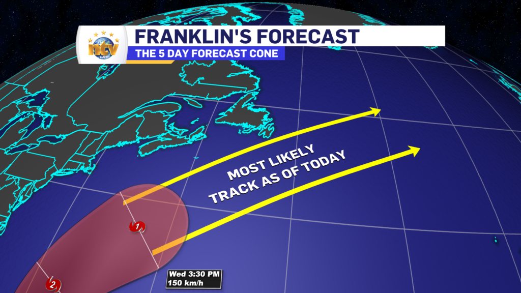
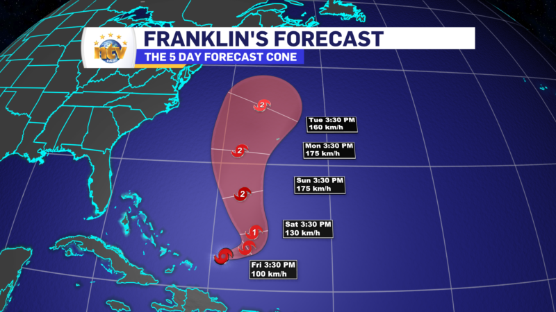
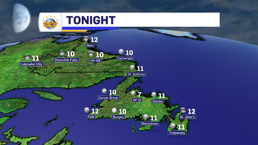
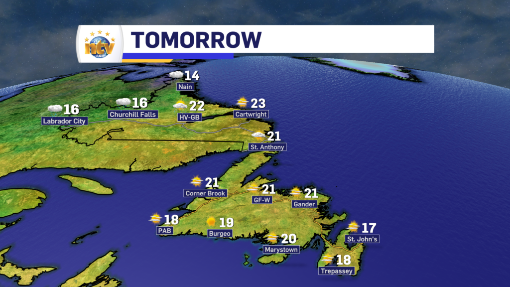
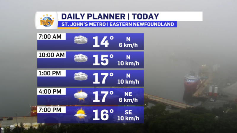
Eddie’s update; Showers start our Monday, and Sunshine finishes it.

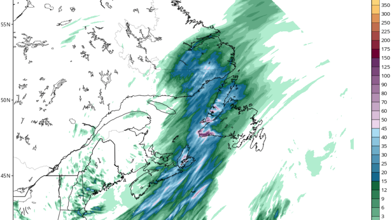
Areas of showers across a good bit of the Province have started our Monday off on a bit of a soggy note. The showers will generally move offshore over the next few hours and the clouds will follow suit. It may be hard to imagine now, but by early afternoon, much of N.L. will be in the sunshine. Highs today will be in the teens to near 20º.

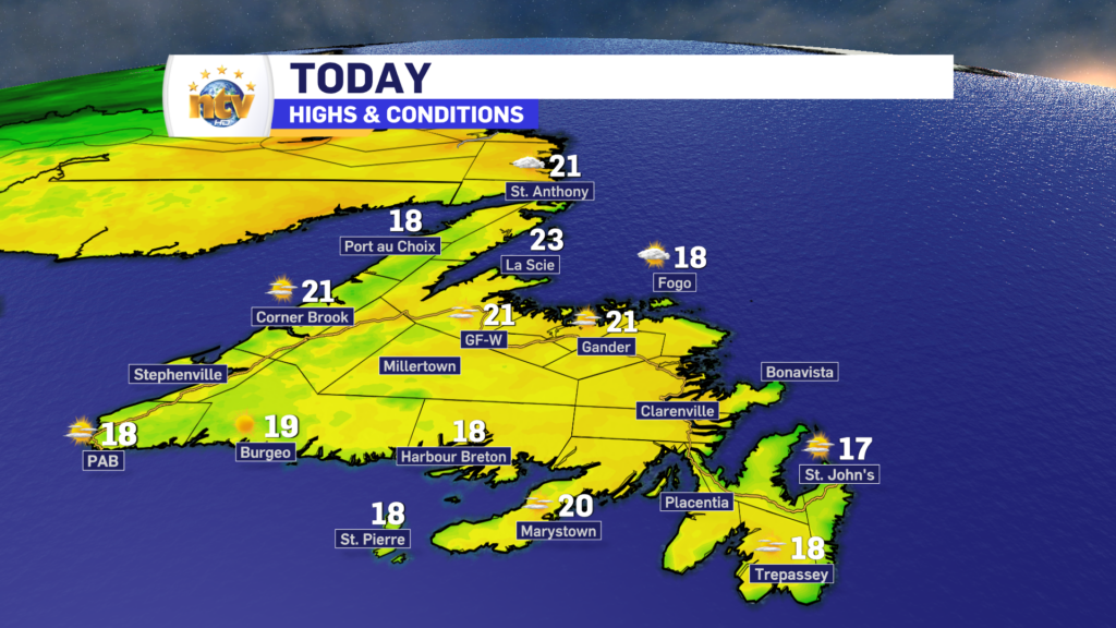
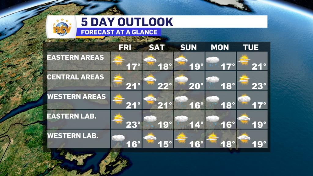
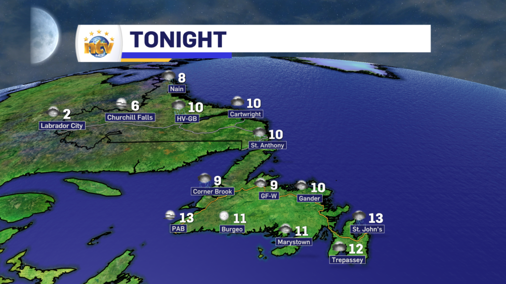
The map below shows us how the day will play out, on a Provincial scale.

Sunday’s Forecast; Rain arrives on the West Coast and southeast Labrador

Update as of 9:34 AM NDT — The showers have moved into Central much earlier than forecast. And will be on and off for the rest of the day.

A slow-moving area of low pressure in the Gulf of St. Lawrence will into the Lower North Shore of Quebec and southeast Labrador and this will drive rain into the western third of Newfoundland and into southeast Labrador.

The heaviest rain today will be over western Newfoundland, while the rain in the southeast corner of Labrador will be significantly lighter. Showers and periods of rain will also be found in Central today.

Meanwhile, in northern and western Labrador and the eastern 2/3 of the Island, we can expect a decent Sunday, with highs in the teens to near 20º. Expect partly to mostly cloudy skies for the majority of the Province outside of the rain.

The rain over western areas will work eastward overnight, and that will end up over the eastern 2/3 of the Island for Monday. Meanwhile, the rain will taper to showers on Monday for western Newfoundland and southeast Labrador. Highs will be into the teens.

Have a great Sunday!

Eddie

Sunshine and rain juxtapose the weather across N.L. this weekend + A Franklin Update

The weekend Overview

Saturday will see sunny skies across the Island portion of the Province, with highs in the upper teens to lower 20s. There will be some fog patches along some shorelines to start the day. Meanwhile, Labrador will see rain working from the west to the southeast throughout the day. Highs in the Big Land reach the 20s in the southeast, and teens pretty much everywhere else.

Sunday will see dry and partly sunny conditions over central and eastern Newfoundland, while rain becomes heavy at times for the West Coast and Great Northern Peninsula. Highs range from the mid-teens to about 20°. Southeast Labrador will also see rain on Sunday, and it will be heavy at times. In the north and west, the rain will end. Highs reach the middle to upper teens.

Rainfall will be highest in southern Labrador and southern and western Newfoundland between later Saturday and early Monday. Some areas of the southwest coast may see over 50 mm of rain. Rainfall Warnings may required from Environment Canada.

Tropical Storm Franklin is going to gain strength over the weekend and will begin to make its way toward the region.

As of now, the forecast has the storm passing near, or over, southeastern Newfoundland between Wednesday and Thursday of next week. At that point, it will be weakening from a Hurricane and accelerating in speed. Generally, when storms are nearing this area, the highest wind speeds are on the right-hand side, and the heaviest rain the left.

As of Friday evening, it is looking more likely than not, that the storm will pass southeast of the Island next week. If that is the case, the main hazard from the system will be heavy rain, with the highest winds remaining offshore. Where the heaviest rain will be and how many falls, it’s still too early to get into that. However, the forecasts will get clearer over the coming days.

Stay tuned.

Friday’s forecast: Sunny on the Island, not so much in Labrador. Also; TS Franklin Update

Good Friday morning!

The weather across the Island today should be nicer, and calmer, than yesterday. We can expect mostly sunny, to even sunny, skies throughout the day. However… on the Avalon, it looks like the clouds will not fully clear off until later this morning. The image below is a cloud cover forecast for St. John’s. Time is on the bottom and cloud cover is on the y-axis from 0-100%. As you can see, between 8 AM and 10 AM, or a bit later, we will start to see the skies clear off.

Cloud cover forecast for St. John’s

Temperatures across the Island will peak in the upper teens to about 20º today, and overall wind speeds will be light. It will be a lovely day to close out the work week.

Meanwhile, in Labrador, rain will spread into the west throughout the day. The rain will become heavy at times this afternoon. Farther east, clouds will spill in after a sunny start. Along with that, the rain will work its way up toward the North Coast by the afternoon. Highs in the Big Land will generally be into the teens today.

Franklin Update

As of this morning, Tropical Storm Franklin is still spinning in the Atlantic north of the Caribbean Islands. The storm’s strength hasn’t changed much since yesterday and isn’t forecast to change much over the next 48 hours.

Beyond that Franklin is forecast to strengthen as it begins to move north in the western Atlantic. At this point, it is still looking like Franklin will become a Hurricane, and possibly a major hurricane (category 3 or higher) in the next couple of days, before weakening as it begins to approach the North Atlantic and subsequently Atlantic Canada.

While it’s still early, it is looking like Franklin will be near the region, likely Newfoundland, during the Wednesday/Thursday time frame of next week. What impacts it brings are still a bit fuzzy, but depending on track and proximity, rain and wind are a good bet. Where the heaviest rain will be along with the highest wind speeds are not able to forecast with any accuracy. High waves and storm surge are also on the docket, but again where the storm tracks will be crucial, and at this point that kind of granularity is just not possible. It will become more clear in the next couple of days.

Eddie’s Thursday night forecast – August 24, 2023

Tonight’s Outlook

The showers across the Island will ease off and eventually end overnight. Lows will fall to near 10º for most locations, and by tomorrow morning skies will be mostly clear.

Much of Labrador will see a quiet night, initially but showers and areas of rain will push into the west late tonight and early Friday morning. Lows will be, on average, near 10º.

Tomorrow’s Outlook

The Island will see a large day, with sunshine and highs near 20º. Also, wind speeds will be light.

Labrador will see rain in the north and west, and sunshine in the east and south, Goose Bay will see rain moving in during the second half of the day. The rain will become more widespread Friday evening and night.

Extended Forecast

The weekend will be pretty decent on the Island, while rain will become more widespread in Labrador. The West will see rain Saturday and that will move to the coast and southeast on Sunday. Temperatures look to be seasonable.

Rain will work across the Island Sunday night and Monday and things will clear out for Tuesday. Again, highs will be near 20º.

Beyond Tuesday we will be watching what Tropical Storm, soon to be Hurricane, Franklin. Current projections indicate that the storm will be close to our region on Wednesday or Thursday. Impacts, at this point, cannot be determined but the storm will have wind and rain with it. Where the heaviest rain and highest wind speeds will be found will be determined by the track. However, as with most storms, as it reaches this latitude it will be weakening.

Eddie’s morning update | August 24, 2023

Good Thursday morning!

We are waking up to generally quiet conditions across much of the Province this morning, however we are seeing some showers over and near the West Coast and interior parts of Labrador. The radar loop from Marble Mountain shows showers, some heavy, approaching the West Coast at this hour (6:36 AM NDT) from Corner Brook to Daniel’s Harbour. They are heading toward the north, northeast.

The showers will be something we see over parts of western, northwest, and central Newfoundland at times today. I also cannot rule out the chance of isolated showers over eastern regions this afternoon. There will also be some scattered showers in Labrador today. Outside of that, we are looking at partly cloudy to mostly sunny skies for much of the Province.

The exception will be on the Avalon, where clouds will linger into the early afternoon before clearing out after 1 or 2 PM. This evening should be large for the easternmost Peninsula! The hourly forecast shows this rather well.

Tropical Storm Franklin Update

The overnight guidance for Tropical Storm Franklin’s future track shifted considerably overnight toward the northwest, according to nearly all the computer model guidance I’m looking at this morning.

So what does this mean? It means we need to continue to pay attention to the storm and subsequent forecasts. The timing of this is still during the middle part of next week (WED/THU ) for the region.

We also need to NOT get caught up in specific details on impacts at this time. Once the storm gets moving we will see how it’s going to interact with 2 other features to its north, and at that point, we can start to identify what areas may, or may not, get x, y, and z from the storm.

Remember, this is a marathon and not a sprint. Stay tuned for more updates.

Eddie’s Wednesday evening forecast; nicer days ahead… sort of!

Newfoundland Tonight

Areas of showers and/or drizzle will continue on the Avalon throughout the overnight. Areas to the west, which is pretty much the rest of the Island, will see partly cloudy to mostly clear skies. Showers will move onto the West Coast and parts of the GNP after midnight. Lows will be in the 9° to 13° range, with light wind speeds.

Labrador Tonight

Scattered showers become isolated and/or end. Partly to mostly cloudy with lows of 6° to 10°, except near Labrador City, where the low will be closer to 2°.

Newfoundland Tomorrow

On the Avalon, we will start cloudy, but skies will turn partly cloudy by the afternoon. The rest of the Island will see a mix of sun and cloud, with scattered showers. The showers will be most widespread over parts of the West Coast, GNP, and Central during the afternoon. Outside of there, any showers will be quite isolated. Highs of 17° to 20°.

Labrador Tomorrow

A mix of sun and cloud with scattered showers from Goose Bay to the southeast coast. Highs of 12° in the north, and 15° to 18° elsewhere.

The Extended

Friday will be a gorgeous day across the Island, with highs near 20° and mostly sunny skies. Meanwhile, Labrador West will see rain through much of the day, while the rest of the Big Land will see nicer weather. Highs of 14° to 22° in the Big Land, with the warmest readings along the coast.

The Island will see a nice Saturday, with highs in the upper teens to near 20. Northern and western Labrador will be dry, while rain falls in the southeast. Highs in the lower teens in the west to low 20s on the coast.

A decent Wednesday for much of N.L., except on the Avalon, where showers linger into the early afternoon… or later

Good Wednesday morning!

We are waking to rain falling over most of the Avalon Peninsula this morning. Rainfall totals since yesterday are highest around the Argentia area where roughly 29 mm has fallen since late Sunday night / early Monday morning.

Future radar shows the rain and showers will linger on the Avalon into the early afternoon before ending either this afternoon or evening. Some guidance keeps the showers on the go until much later in the day. Today will not be as rainy as yesterday, but it’s not exactly going to be sunny and dry either. In fact, once the rain ends on the easternmost Peninsula, expect skies to remain cloudy for the remainder of the day. Temperatures will hover in the middle teens.

The rest of the Island will see sunny skies (west) or skies turning sunny (south, central and northeast) as the day goes on. Labrador will see scattered showers throughout the day. Highs today range from the teens to about 20, with the warmest readings being found over southern and western Newfoundland.

The rest of this work week is fairly quiet across much of the Province with more in the way of sunshine and temperatures remaining seasonable. However, parts of the Big Land will see some rain on Friday. I’ll get more specific on that later today.

I’ll also have an update on the tropics, meaning Tropical Storm Franklin. At this point, it’s still too early to make any determination on what impacts Franklin may have in the region. All I can tell you is that computer guidance indicates the center may be near the area during the. the mid part of next week. Beyond that, we need to wait a few days to figure out where it will be and the subsequent impacts that may, or may not cause.

Tuesday morning update; Rain for the Avalon and Burin Peninsulas today

Tuesday’s Outlook

The Avalon, and some adjacent areas, will see periods of rain as the cold front slowly meanders eastward. The rest of the Island will generally see partly to mostly cloudy skies. Highs will be in the upper teens to near 20°.

Labrador will see a quiet day, with scattered showers in the afternoon. Highs range from near 20° on the South Coast, to 12° north. Goose Bay will be near 20°, while western areas will be near 12°.

The Extended

Wednesday

Rain will linger on the Avalon into Wednesday morning before ending mid-morning. Rainfall amounts will be in the 25-50 mm range for the Avalon, with locally higher amounts possible. The rest of the Island will see scattered showers on Wednesday. Highs will be in the mid to upper teens under partly to mostly cloudy skies. Labrador will see scattered showers and highs in the lower to middle teens.

Thursday: Scattered showers across the Province under sun and cloud. Highs in the mid to upper teens.

Friday: Partly cloudy to mostly sunny with highs in the mid-teens to near 20.

Saturday: Chance of rain across the Island and southeast Labrador. Highs in the mid-teens to near 20.

Eddie’s Monday evening update for August 21, 2023

Tonight’s Outlook

A cold front will sweep across most of the Island tonight, but it will get hung up on the Avalon. The front will act as a focus mechanism for rain, and rain will develop on the easternmost Peninsula later this evening and overnight. Areas to the west, and I mean just to the west, will hardly see any rainfall tonight.

There are also some showers on the go over western areas of the Island this afternoon, which will also come to an end this evening.

Rain on the eastern side of the Big Land will move offshore this evening, while scattered showers take hold in the west.

Lows range from 8 to 12 in Labrador and the lower to middle teens on the Island.

Tuesday’s Outlook

The Avalon, and some adjacent areas, will see periods of rain as the cold front slowly meanders eastward. The rest of the Island will generally see partly to mostly cloudy skies. Highs will be in the upper teens to near 20°.

Labrador will see a quiet day, with scattered showers in the afternoon. Highs range from near 20° on the South Coast, to 12° north. Goose Bay will be near 20°, while western areas will be near 12°.

The Extended

Wednesday

Rain will linger on the Avalon into Wednesday morning before ending mid-morning. Rainfall amounts will be in the 25-50 mm range for the Avalon, with locally higher amounts possible. The rest of the Island will see scattered showers on Wednesday. Highs will be in the mid to upper teens under partly to mostly cloudy skies. Labrador will see scattered showers and highs in the lower to middle teens.

Thursday: Scattered showers across the Province under sun and cloud. Highs in the mid to upper teens.

Friday: Partly cloudy to mstly sunny with highs in the mid-teens to near 20.

Saturday: Chance of rain across the Island and southeast Labrador. Highs in the mid-teens to near 20.

Scroll to top