weather forecast

Eddie’s forecast; blogging about today’s forecast and the tropics getting active

Good Monday morning!

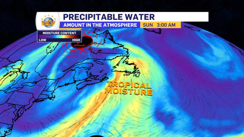
We are in the midst of a tropical moisture push that is helping to drive up humidity levels across a large part of the Province. On the plus side, it does look like the highest atmospheric moisture content has slid east of Newfoundland. On the loop below, the brighter the colour, the more moisture, and thus humidity, is in the air. Notice how the brightest is now east of the Avalon?

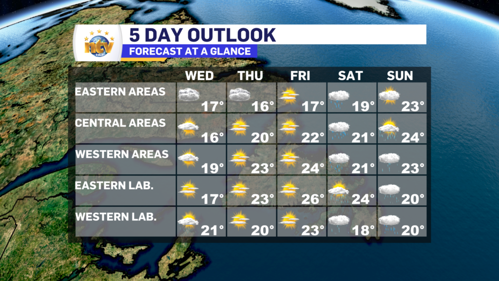
That being said, we aren’t exactly out of the woods yet, with respect to the humidity. Particularly in eastern Newfoundland, where it looks to remain humid through Tuesday, while it gets noticeably more comfortable to the west. It will dry out for the Avalon by Wednesday.

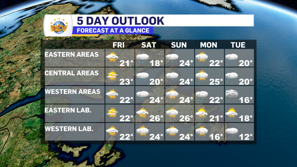
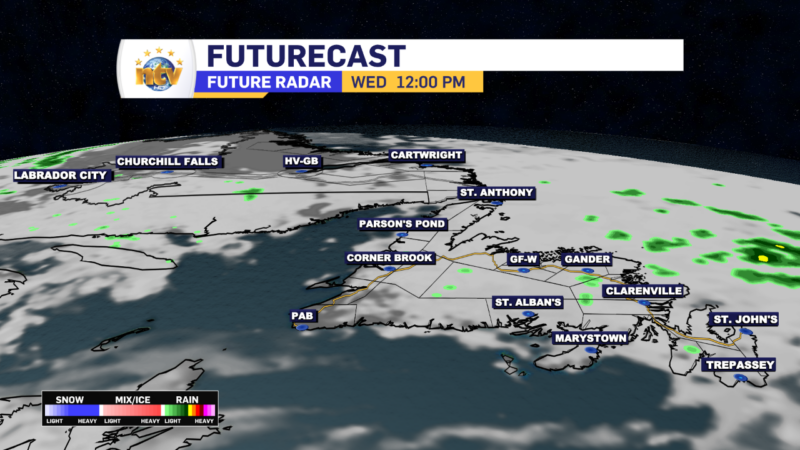
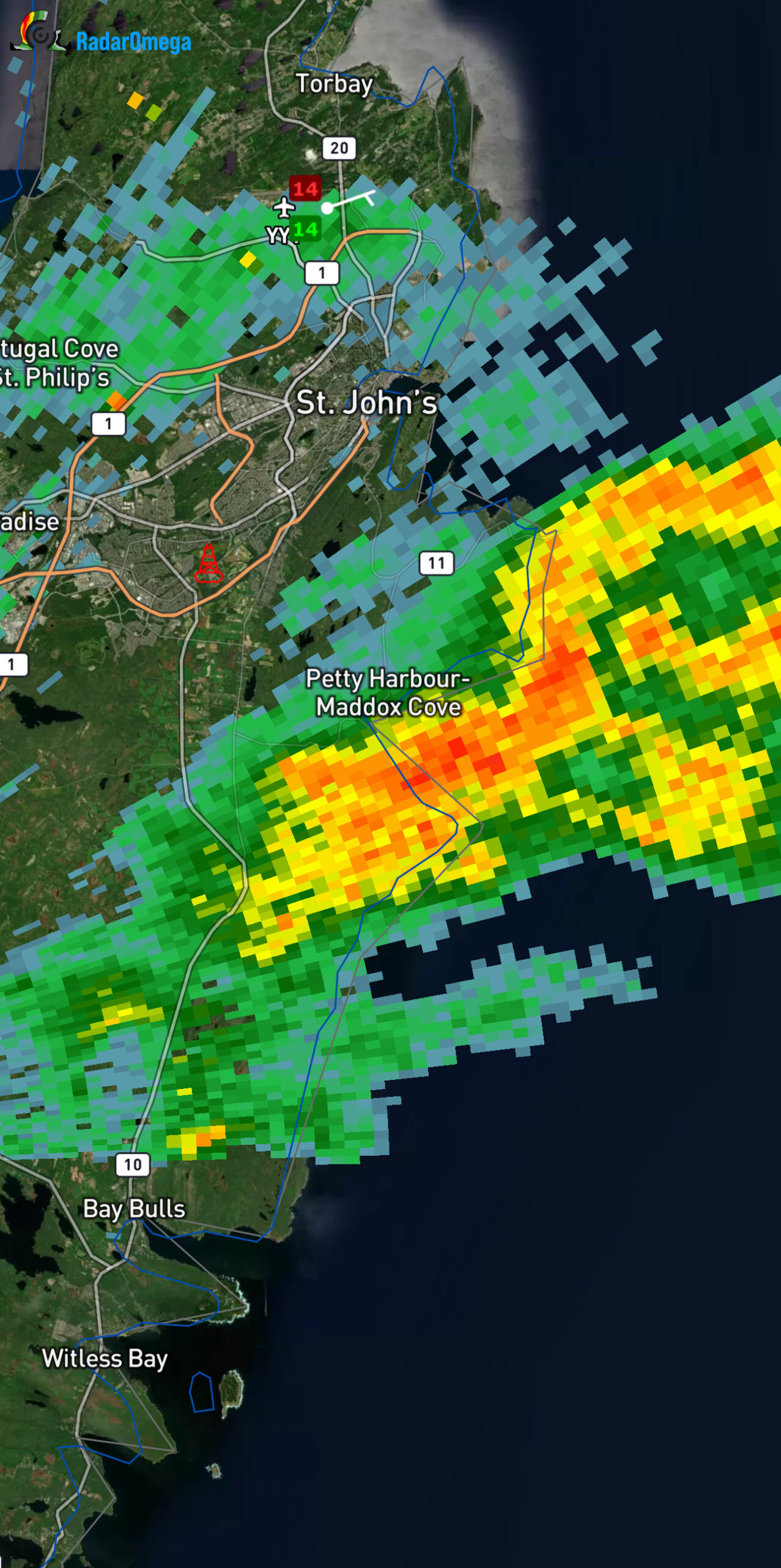
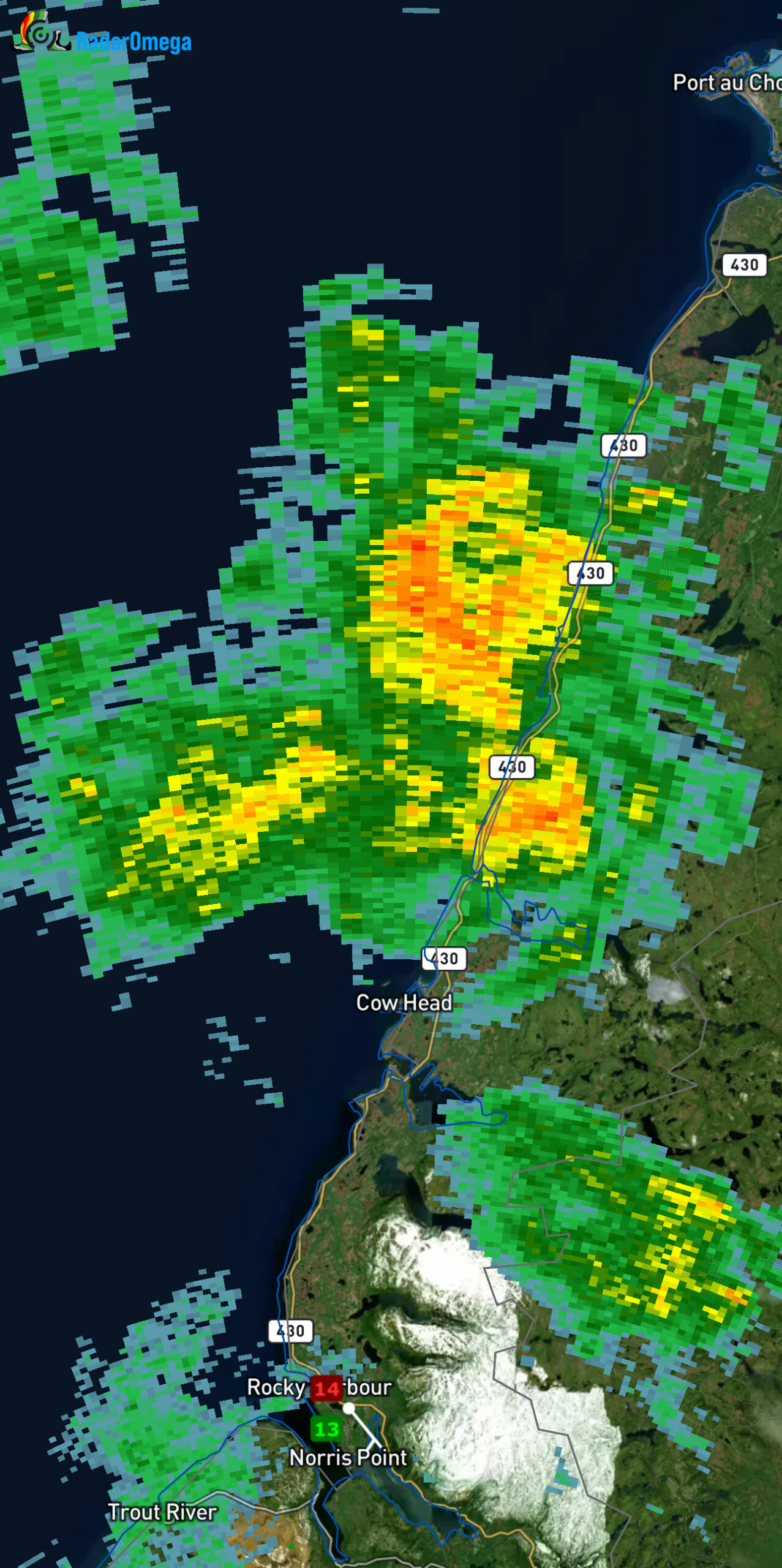
For the rest of today, we are looking at areas of rain and showers working through Labrador and western Newfoundland, and to a point in central Newfoundland. Some of the showers will be locally heavy and there will be some isolated thunderstorms.

Futurecast shows how this will pan out today.

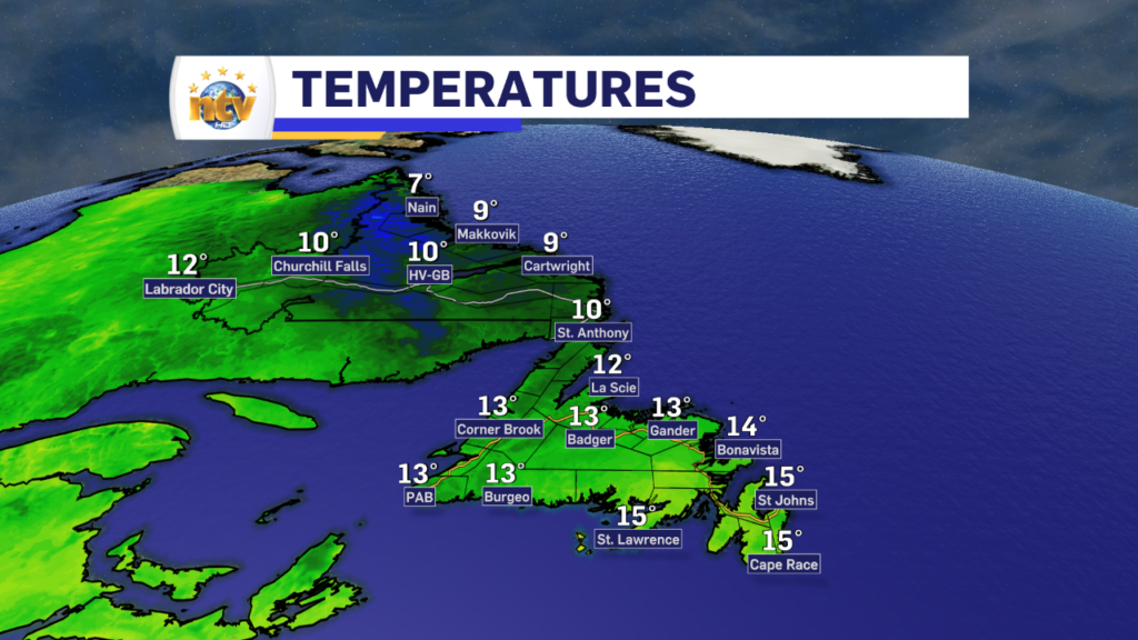
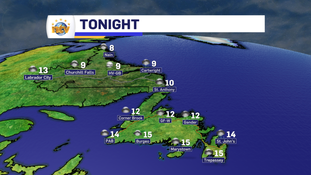
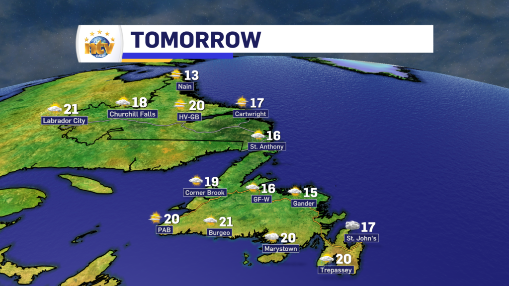
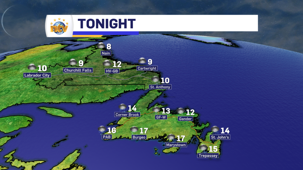
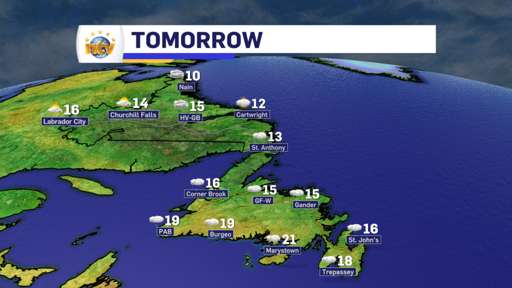
Temperatures today peak into the teens and 20s across the Province, with humidex values into the upper 20s over eastern sections of the Island. The muggies are here for some of us!

The tropics are also getting active, which shouldn’t come as a shock as last week I was talking about a few waves that were likely to develop into systems. This morning we have 3 named systems in the Basin, Emily, Gert, and Franklin. There is the potential for 2 more storms to develop as well in the next few days.

While we need to pay attention to many systems in the Atlantic this time of year, the one you need to remember here is Franklin. Some computer model guidance is suggesting this may impact Atlantic Canada in the next 7 to 10 days.

At this point, it’s still way too early to say what, if any, the impacts will be. Needless to say, I’ll be watching them all closely.

Have a great Monday!

Eddie

Sunday’s update; the muggies make a comeback

Sunday morning is starting off with widespread showers across much of the Island this morning. The showers have developed along and behind a warm front that is in the process of lifting through. Behind that warm front, you will notice a solid increase in the mugginess (if that’s a word) across most of Newfoundland.

Over the last few hours, this is a radar loop from MSC radar in Holyrood.

While it’s much calmer over central and western areas of the Island right now, there was a hefty showers that went through the Badger to Bishop’s corridor and moved off toward Birchy Bay and Back Harbour. There were even some lightning strikes recorded, so this was indeed a thunderstorm.

Here is a loop from the MSC radar on Marble Mountain.

Rest of Sunday

The rest of your Sunday will see an increase in the number of showers over the Island portion of the Province, along with an uptick in temperatures and humidity. Humidex values this afternoon will creep into the upper 20s to lower 30s for Central.

The amazing thing about that is temperatures will only be in the lower to middle 20s. This speaks to just how humid this air mass is. In fact, the air coming in has tropical origins as we can see from today’s precipitable water (PWAT) chart.

Here is a look at the expected high temperatures today across the Province.

Showers and rain become more widespread later today on the Island, let’s say after 1 PM NDT. And this area of rain will affect mainly central, northwest (GNP), and eastern areas into tonight and early Monday morning, while at the same time, another area of rain will move into Labrador West this evening and trudge northward for Monday morning.

More on that later. Have a great Sunday!

Eddie

This weekend looks to be on the soggy side for much of the Province

A slow-moving area of low pressure will help drive unsettled weather across much of the Province for the weekend. You will also notice an uptick in the humidity as tropical moisture gets swept northward on the backside of a Bermuda High.

Saturday’s Outlook

Periods of rain and showers across the Island, with highs in the upper teens to middle 20s. Humidex values into the mid-20s by afternoon as tropical moisture surges north. Risk of thunderstorms.

Showers also become more numerous in Labrador, with highs in the upper teens to middle 20s.

Sunday’s Outlook

Periods of rain and/or showers across the Island with highs in the mid-20s. Humidex values into the upper 20s to lower 30s as a surge of tropical moisture works though. The weather will improve a bit Sunday night as the rain moves out. However, showers may linger in some areas into Monday morning. Risk of thunderstorms over the southwest corner of the Island.

Labrador will see a few showers as well, along with highs in the upper teens to middle-20s.

For your full forecast, and our interactive radar visit our new weather page!

Friday looks nice, but the weekend… not so much

Friday looks like another decent day across the region. Expect highs in the upper teens to lower teens on the Island, with Labrador looking at the middle to upper 20s for high. The warmest readings look to be found between Norman Bay and Lodge Bay.

As our next low begins to make its presence known, rain showers begin to spread into the southwest late this afternoon or evening. The showers will spread north Friday night and will turn into steadier rain for much of the Island by Saturday.

Speaking of Saturday and Sunday, expect a fair bit of shower and rain activity across the Island. But with that, will come more humidity and warmer temperatures, particularly for Sunday. Skies clear out for Monday which will allow for a hot and humid day, followed by more rain on the way for Tuesday for parts of the Island.

Labrador will generally remain fairly quiet over the next 3 to 5 days.

CLICK HERE TO FIND YOUR 7-DAY FORECAST AND FOR OUR LIVE INTERACTIVE RADAR

Thursday looks nice across the Province!

Good Thursday morning!

Based on the webcams and satellite imagery, we are waking up to a mix of clear and cloudy skies across the Province this morning. The webcams and NTV SkyCams I have access to show that rather well, and here are some camera images from across the Province this morning.

The satellite imagery from this morning also shows we are seeing some areas of cloud around the region, and likely some scattered light showers and under that cloud, although the radar imagery I’m seeing doesn’t reflect that super well.

An area of high pressure will build in today, and this will set the stage for a generally sunny day across the Province.

Temperatures will peak into the teens to lower 20s for the Province today, and wind speeds look to be fairly light, although, for parts of Labrador, mainly north and west, it will be a little breezy. The reason for this is a strong low-pressure centre to our west will create a stronger pressure gradient over the area.

A pressure gradient is a fancy term for how much sea level pressure changes over a given distance. In this case, the gradient is tight, meaning there is a large change. And since air likes to flow from high to low, that will generally mean increased wind speeds. Wind speeds today in Labrador West will gust near 40 or 50 km/h.

Friday looks similar and rain comes in Saturday. Your next update will be posted this afternoon!

Wednesday morning forecast; slow improvements today as the showers depart

This morning we are waking up to more showers and clouds across a good chunk of the Island, specifically in central and eastern areas. There are even some foggy patches. Farther west we are looking at some breaks of clear sky.

Temperatures are into the mid-teens and wind speeds are light on the Island. Labrador is seeing readings in the lower teens and even some single digits to begin the day.

Temperatures as of 6:30 AM NDT / 6 AM ADT

Today will see clouds decrease across the Island from west to east. In the west, the skies will turn sunny this morning, in Central that will be this afternoon, and in the east, it may not be until this evening.

Temperatures this afternoon will creep into the mid-teens to lower 20s for most areas of the Province. There will be some pop-up showers in Labrador West later today. Most of which should be minor.

Today’s forecast – August 16, 2023

A peek at the extended

The rest of this week looks pretty good. Expect sunshine Thursday and Friday, with highs in the upper teens to lower 20s across the Province. The next chance of rain comes on Friday night and Saturday for Labrador West and the Island portion of the Province. I’ll further updates on this.

Have a great day!

Eddie

Eddie’s Tuesday evening forecast; rain showers tonight, less for Wednesday

Tonight’s Outlook

A weakening area of low pressure will swirl across the Island overnight. This will keep on-and-off showers on the go for areas of western, central, and eastern Newfoundland while the South Coast remains primarily dry. Lows in the lower to middle teens. Some coastal locations will see fog patches overnight. Wind speeds will be light.

Expect a few showers in Labrador in the southeast and the west overnight. Otherwise, it’s dry and partly to mostly cloudy. Lows near 10°.

Wednesday’s Outlook

A few showers will be found over eastern and central areas in the morning. The showers will end by early afternoon and skies will gradually turn partly to mostly cloudy. Areas of western Newfoundland, the GNP, and the South Coast will generally see sunshine. Highs range from the mid to upper teens east and central, to lower teens on the GNP, and near 20 for the West Coast and South Coast.

Labrador can expect mostly sunny skies, with highs in the teens to near 20. The cooler readings will be found on the north coast, while the mid to upper teens and near 20 will be found farther south and west.

Extended Outlook

Thursday looks quiet and sunny across the Province, with highs in the mid-teens in eastern Newfoundland to near 20, or higher, just about everywhere else in NL.

Friday will see be mostly sunny with highs in the upper teens to lower 20s.

Saturday will see periods of rain across much of the Province as an area of low-pressure swings through the region. Highs will be near 20°. Sunday will be a tad warmer, with highs in the lower to middle 20s. Showers may still be around.

Rain showers, drizzle, and fog will comprise Tuesday’s weather for the Island, while Labrador has a lovely day!

We are off to a bit of a foggy start this morning over parts of eastern and northeastern Newfoundland and cannot say that’s a surprise. The visibility at St. John’s airport this morning is being reported at 200 meters. This may have an impact on air travel from St. John’s Airport, so if you’re flying, be sure to check with your carrier.

St. John’s Int’l Airport webcam – 6:07 AM NDT on August 15, 2023

We are also seeing some rain showers across much of the Island to begin the day. The rain showers are numerous over both the eastern and western sections of the Island this morning. Some rain shower cells are quite heavy. The area between the Goulds, Petty Harbour, and Bay Bulls has been in and out of the heavy rain for the last hour or so. The showers are moving from west to east and should end up offshore in the next hour or less.

Areas of showers and/or light rain will continue to affect much of western, central, and eastern Newfoundland throughout the day. Fog will be an issue as well near east-facing shores thanks to onshore easterlies. The fog should get a little less dense for areas that see it, mainly the eastern parts of the Avalon, this evening as the wind turns from east to southeast. Skies remain cloudy today and highs peak in the mid to upper teens. Some spotty 20º readings may be found along the South Coast this afternoon.

And speaking of the South Coast, that’s the area that may see some sunny breaks on the Island today. And is probably the only area that will see that.

Max temperatures today, RDPS Model for August 15, 2023

Labrador will see a decent day, with highs in the teens to near 20. There will be some showers in the West later today, but overall the best weather today will be found in the Big Land.

The weather will improve… at least somewhat, for Wednesday. And I’ll have a more detailed update on that later today.

Have a good one!

Eddie

Eddie’s Evening Update; showers and rain return for Tuesday

A weak area of low pressure will swirl across the Island over the next 12 hours or so and will bring areas of rain, showers, and even the risk of some passing thunderstorms with it. The storm risk is overnight and anything that does develop should be rather isolated. This image from ECCC shows where the risk of minor storms is highest overnight.

Outside of the passing storms, showers will be widespread, along with areas of rain, tonight and Tuesday across much of the Province. It will also turn a bit cooler for most of us during the next 24 hours as winds turn onshore. Fog patches are possible too, mainly over eastern areas, through the time frame.

Lows tonight will be in the teens on the Island and teens to single digits in Labrador. Speaking of Labrador, expect quiet weather overnight and Tuesday. The only thing to look out for Tuesday will be some showers in the west during the afternoon.

The remainder of the week looks to remain on the cooler side across much of the Island as winds look to remain onshore. The reason for this will be a stubborn high setting up show north northeast of the Island. Chance for rain returns for southern and eastern sections of the Island on Thursday, and more widespread chances come in for Saturday.

Meanwhile, in Labrador, the weather looks to remain quiet for the next 4 or 5 days, with only scattered showers in the forecast. Temperatures rise to warmer-than-average levels by the middle and end of the work-week.

For your latest 7-day forecast and our live interactive radar, be sure to bookmark our weather page!

Eddie’s Update; Sunday’s forecast

Sunday will be a beautiful day across much of Newfoundland and Labrador. Expect partly cloudy to mostly sunny skies with highs into the upper teens to lower 20s. Humidex values will be in to the middle/upper 20s for some.

For your latest 7-day forecast and our live interactive radar, bookmark our weather page!

Scroll to top